File:Alam bawah laut Karimunjawa.jpg
Original file (3,000 × 1,685 pixels, file size: 9.78 MB, MIME type: image/jpeg)
Captions
Summary
[edit]DescriptionAlam bawah laut Karimunjawa.jpg |
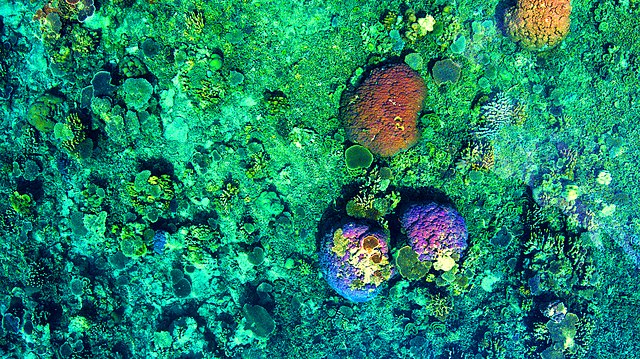
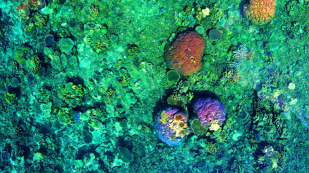
Bahasa Indonesia: Keindahan alam bawah laut di Kawasan Taman Nasional Karimunjawa yang setiap saat sangat mempesona.
Foto diambil di dekat Pulau Menjangan Kecil, Karimunjawa, Kabupaten Jepara, Jawa Tengah. |
Date | |
Source | Own work |
Author | Budi Wasisto |
Camera location | 5° 53′ 26.24″ S, 110° 24′ 10.12″ E | View this and other nearby images on: OpenStreetMap | -5.890623; 110.402811 |
---|
Licensing
[edit]- You are free:
- to share – to copy, distribute and transmit the work
- to remix – to adapt the work
- Under the following conditions:
- attribution – You must give appropriate credit, provide a link to the license, and indicate if changes were made. You may do so in any reasonable manner, but not in any way that suggests the licensor endorses you or your use.
- share alike – If you remix, transform, or build upon the material, you must distribute your contributions under the same or compatible license as the original.
This image was uploaded as part of Wiki Loves Earth 2020.
aragonés ∙ العربية ∙ asturianu ∙ azərbaycanca ∙ беларуская (тарашкевіца) ∙ български ∙ বাংলা ∙ brezhoneg ∙ català ∙ čeština ∙ Cymraeg ∙ Deutsch ∙ Ελληνικά ∙ English ∙ español ∙ eesti ∙ euskara ∙ فارسی ∙ français ∙ galego ∙ עברית ∙ hrvatski ∙ հայերեն ∙ Bahasa Indonesia ∙ italiano ∙ 日本語 ∙ ქართული ∙ 한국어 ∙ latviešu ∙ македонски ∙ മലയാളം ∙ मराठी ∙ Bahasa Melayu ∙ norsk bokmål ∙ नेपाली ∙ Nederlands ∙ norsk ∙ polski ∙ português ∙ português do Brasil ∙ română ∙ русский ∙ sicilianu ∙ shqip ∙ slovenščina ∙ српски / srpski ∙ svenska ∙ ไทย ∙ Türkçe ∙ українська ∙ اردو ∙ 简体中文 ∙ 繁體中文 ∙ +/− |
File history
Click on a date/time to view the file as it appeared at that time.
Date/Time | Thumbnail | Dimensions | User | Comment | |
---|---|---|---|---|---|
current | 09:53, 22 May 2020 | 3,000 × 1,685 (9.78 MB) | Budi Wasisto (talk | contribs) | Uploaded own work with UploadWizard |
You cannot overwrite this file.
File usage on Commons
There are no pages that use this file.
Metadata
This file contains additional information such as Exif metadata which may have been added by the digital camera, scanner, or software program used to create or digitize it. If the file has been modified from its original state, some details such as the timestamp may not fully reflect those of the original file. The timestamp is only as accurate as the clock in the camera, and it may be completely wrong.
Camera manufacturer | DJI |
---|---|
Camera model | FC330 |
Exposure time | 13/20,000 sec (0.00065) |
F-number | f/2.8 |
ISO speed rating | 100 |
Date and time of data generation | 14:26, 18 April 2017 |
Lens focal length | 3.61 mm |
Latitude | 5° 53′ 26.24″ S |
Longitude | 110° 24′ 10.12″ E |
Altitude | 45.406 meters above sea level |
Orientation | Normal |
Software used | ACDSee Pro 5 |
File change date and time | 18:16, 22 April 2017 |
Y and C positioning | Centered |
Exposure Program | 58655 |
Exif version | 2.3 |
Date and time of digitizing | 14:26, 18 April 2017 |
APEX aperture | 2.8 |
APEX exposure bias | −2.34375 |
Maximum land aperture | 2.97 APEX (f/2.8) |
Subject distance | 0 meters |
Metering mode | Center weighted average |
Light source | Unknown |
Flash | Flash did not fire, No flash function |
DateTime subseconds | 401 |
File source | Digital still camera |
Scene type | A directly photographed image |
Custom image processing | Normal process |
Exposure mode | Auto exposure |
White balance | Auto white balance |
Digital zoom ratio | 0 |
Focal length in 35 mm film | 20 mm |
Scene capture type | Standard |
Scene control | None |
Contrast | Normal |
Saturation | Normal |
Sharpness | Normal |
Subject distance range | Unknown |
GPS tag version | 0.0.3.2 |
Structured data
Items portrayed in this file
depicts
18 April 2017
5°53'26.243"S, 110°24'10.120"E
0.00065 second
2.8
3.61 millimetre
100
image/jpeg
a4e959e83f68551234ae258c29e26c4e633e09a8
10,255,614 byte
1,685 pixel
3,000 pixel
- Files with coordinates missing SDC location of creation
- CC-BY-SA-4.0
- Self-published work
- Images from Wiki Loves Earth 2020
- Images from Wiki Loves Earth 2020 in Indonesia
- Images from Wiki Loves Earth missing SDC depicts
- Images from Wiki Loves Earth missing SDC location of creation
- Uploaded via Campaign:wle-id