File:Al-Hamra stele at National Museum of Korea.jpg
Jump to navigation
Jump to search

Size of this preview: 450 × 600 pixels. Other resolutions: 180 × 240 pixels | 360 × 480 pixels | 576 × 768 pixels | 768 × 1,024 pixels | 1,536 × 2,048 pixels | 3,024 × 4,032 pixels.
Original file (3,024 × 4,032 pixels, file size: 2.51 MB, MIME type: image/jpeg)
Captions
Captions
Add a one-line explanation of what this file represents
Summary
[edit]
| Description |
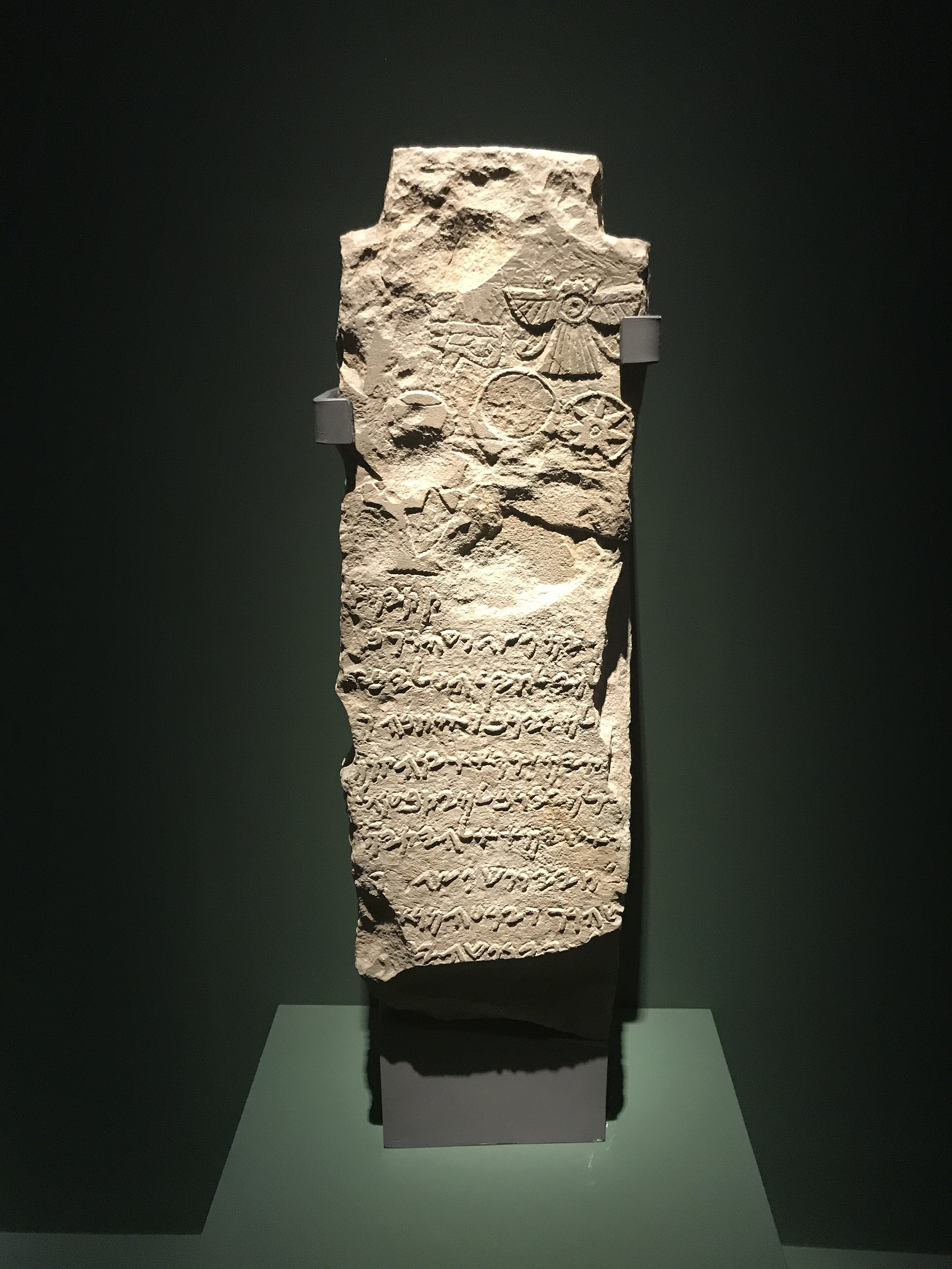
العربية: مسلة قصر الحمراء تعود إلى الفترة من القرن الخامس إلى الرابع قبل الميلاد. - المعطيات الأثرية كشفت أن تيماء في العصر البرونزي كانت مركزا حضاريا عالميا، وذات صلة وثيقة بحضارات داخل الجزيرة العربية، وأخرى خارجها، وكانت منارة للتبادل التجاري بين الشرق والغرب وشمال وجنوب الجزيرة العربية. رغم وجود بقايا استيطان بشري تعود إلى أواخر العصر الحجري الحديث (أواخر الألفية السابعة وأوائل الألفية السادسة قبل الميلاد)، إلا أن الزراعة في واحة تيماء تعود إلى 4300 قبل الميلاد فصاعدا، ومن محاصيلها الكروم والتين. حضارة تيماء ارتبطت بحضارات في الجزيرة العربية مثل (دادان والحجر) وحضارات أخرى خارج الجزيرة العربية مثل (بلاد الرافدين وبلاد الشام). هذا الوعاء من القطع المختارة لمعرض «روائع آثار المملكة عبر العصور» الذي زار أشهر المتاحف العالمية.
English: The Obelisk of the Alhambra dates back to the period from the fifth to the fourth century BC. - Archaeological data revealed that Tayma in the Bronze Age was a global cultural center, closely related to civilizations inside and outside the Arabian Peninsula, and was a beacon of trade exchange between East and West, North and South Arabia. Although there are remnants of human settlement dating back to the late Neolithic period (late seventh and early sixth millennium BC), agriculture in the oasis of Tayma dates back to 4300 BC onwards, and its crops include vines and figs. The Tayma civilization was associated with civilizations in the Arabian Peninsula, such as (Dadan and Al-Hajar) and other civilizations outside the Arabian Peninsula, such as (Mesopotamia and the Levant). This vessel is one of the selected pieces for the exhibition “Masterpieces of Antiquities of the Kingdom Through the Ages”, which visited the most famous international museums. |
| Date | Taken on 15 June 2017 11:05:45 |
| Source | Own work |
| Author | Explicit |
| Camera location | | View this and other nearby images on: OpenStreetMap |
|---|
This photograph was taken with an iPhone 7
Licensing
[edit]
I, the copyright holder of this work, hereby publish it under the following license:
This file is licensed under the Creative Commons Attribution-Share Alike 4.0 International license.
- You are free:
- to share – to copy, distribute and transmit the work
- to remix – to adapt the work
- Under the following conditions:
- attribution – You must give appropriate credit, provide a link to the license, and indicate if changes were made. You may do so in any reasonable manner, but not in any way that suggests the licensor endorses you or your use.
- share alike – If you remix, transform, or build upon the material, you must distribute your contributions under the same or compatible license as the original.
File history
Click on a date/time to view the file as it appeared at that time.
| Date/Time | Thumbnail | Dimensions | User | Comment | |
|---|---|---|---|---|---|
| current | 10:39, 23 May 2018 | | 3,024 × 4,032 (2.51 MB) | Explicit (talk | contribs) | User created page with UploadWizard |
You cannot overwrite this file.
File usage on Commons
The following page uses this file: