File:Alūksne Castle plan.jpeg
Jump to navigation
Jump to search

Size of this preview: 404 × 600 pixels. Other resolutions: 161 × 240 pixels | 323 × 480 pixels | 848 × 1,259 pixels.
Original file (848 × 1,259 pixels, file size: 264 KB, MIME type: image/jpeg)
Captions
Captions
Add a one-line explanation of what this file represents
Summary
[edit]
| Description |
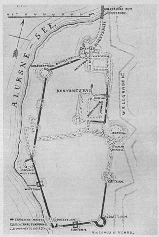
English: Ground plan of the Alūksne Castle according Karl von Lövis of Menar. Dark lines: visible walls; shaded lines: visible basements; dashed: basement under rubble.
Visibility of walls mostly corresponds to that of 2010. |
| Date | end of XIX century (?) |
| Source | Scanned from A. Tuulse "Die Burgen in Estland und Lettland", Dorpat 1942 |
| Author | Karl von Lövis of Menar |
Licensing
[edit]
|
This work is in the public domain in its country of origin and other countries and areas where the copyright term is the author's life plus 70 years or fewer. | |
| This file has been identified as being free of known restrictions under copyright law, including all related and neighboring rights. | |
File history
Click on a date/time to view the file as it appeared at that time.
| Date/Time | Thumbnail | Dimensions | User | Comment | |
|---|---|---|---|---|---|
| current | 05:27, 23 July 2010 | | 848 × 1,259 (264 KB) | Otoomet (talk | contribs) | {{Information |Description={{en|1=Ground plan of the Alūksne Castle according Karl von Lövis of Menar. Dark lines: visible walls; shaded lines: visible basements; dashed: basement under rubble. Visibility of walls mostly corresponds to that of 2010.}} |
You cannot overwrite this file.
File usage on Commons
There are no pages that use this file.
File usage on other wikis
The following other wikis use this file:
- Usage on be.wikipedia.org
- Usage on en.wikipedia.org
- Usage on et.wikipedia.org
- Usage on fr.wikipedia.org
- Usage on lv.wikipedia.org
- Usage on ru.wikipedia.org
- Usage on sv.wikipedia.org