File:Air Kiribati route map.PNG
Jump to navigation
Jump to search

Size of this preview: 788 × 600 pixels. Other resolutions: 316 × 240 pixels | 631 × 480 pixels | 1,010 × 768 pixels | 1,280 × 974 pixels | 2,371 × 1,804 pixels.
Original file (2,371 × 1,804 pixels, file size: 1.15 MB, MIME type: image/png)
Captions
Captions
Add a one-line explanation of what this file represents
Summary
[edit]
| Description |
Català: Mapa amb tots els camís qui vola Air Kiribati.
Deutsch: Karte mit allen Air Kiribati-Verbindungen.
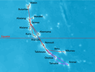
English: Map indicating all Air Kiribati routes.
Español: Mapa con todas las rutas que vuele Air Kiribati.
Français : Carte montrant toutes les routes entretenues par Air Kiribati.
Nederlands: Kaart met alle Air Kiribati-routes.
Shqip: Hartë me itinerarët e gjithë i Air Kiribati. |
| Date | |
| Source | Based on Image:GilbertIslandsPos.png |
| Author | Belgian man |
| Permission (Reusing this file) |
(see "Original source") |
Licensing
[edit]
| I, the copyright holder of this work, release this work into the public domain. This applies worldwide. In some countries this may not be legally possible; if so: I grant anyone the right to use this work for any purpose, without any conditions, unless such conditions are required by law. |
File history
Click on a date/time to view the file as it appeared at that time.
| Date/Time | Thumbnail | Dimensions | User | Comment | |
|---|---|---|---|---|---|
| current | 13:34, 9 June 2008 | | 2,371 × 1,804 (1.15 MB) | Gertjan R. (talk | contribs) | {{Information |Description={{en|1=Map indicating all Air Kiribati routes.}} {{fr|1=Carte montrant toutes les routes entretenues par Air Kiribati.}} {{es|1=Mapa con todas las rutas que vuele Air Kiribati.}} {{de|1=Karte mit alle Air Kiribati-Verbindungen.} |
You cannot overwrite this file.
File usage on Commons
There are no pages that use this file.
File usage on other wikis
The following other wikis use this file:
- Usage on de.wikipedia.org
- Usage on en.wikipedia.org
- Usage on fr.wikipedia.org
- Usage on gl.wikipedia.org
- Usage on ja.wikipedia.org
- Usage on ms.wikipedia.org
- Usage on nl.wikipedia.org
- Usage on pl.wikipedia.org