File:Aichholzhof UFK 1832 landesarchiv-bw.de.jpg
Jump to navigation
Jump to search

Size of this preview: 597 × 600 pixels. Other resolutions: 239 × 240 pixels | 478 × 480 pixels | 764 × 768 pixels | 1,019 × 1,024 pixels | 2,189 × 2,200 pixels.
Original file (2,189 × 2,200 pixels, file size: 971 KB, MIME type: image/jpeg)
Captions
Captions
Add a one-line explanation of what this file represents
| Description |
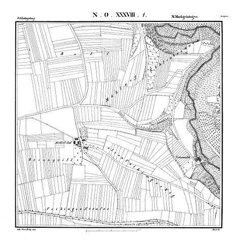
Deutsch: Aichholzhof auf der Markgröninger Urflurkarte von 1832
Kartenblatt NO XXXVIII 1, Stand 1832, Bild 1. Zu sehen ist der Aichholzhof, die Papiermühle, Talhausen, die Untere Mühle, alles auf Markgröninger Gemarkung. Zusätzlich sind die Gewanne Brunnquill (Bronnquill), Eichholzer Feld, Lehle, Mühlberg, Mühlweg, Roll, Alte Vaihinger Weg und Vaihinger Straße und Kühlenbronnen aufgeführt. |
| Date | |
| Source | Landesarchiv Baden-Württemberg (www.landesarchiv-bw.de) |
| Author | Statistisch-Topographisches Bureau des Königreichs Württemberg |
|
This work is in the public domain in its country of origin and other countries and areas where the copyright term is the author's life plus 100 years or fewer. | |
| This file has been identified as being free of known restrictions under copyright law, including all related and neighboring rights. | |
File history
Click on a date/time to view the file as it appeared at that time.
| Date/Time | Thumbnail | Dimensions | User | Comment | |
|---|---|---|---|---|---|
| current | 13:41, 31 December 2014 | | 2,189 × 2,200 (971 KB) | Pustekuchen2014 (talk | contribs) | größeres Bild |
| 16:00, 29 December 2014 |  | 945 × 975 (595 KB) | Grüninger (talk | contribs) | {{Information |Description ={{de|1=Aichholzhof auf der Markgröninger Urflurkarte von 1832 Kartenblatt NO XXXVIII 1, Stand 1832, Bild 1}} |Source =[https://www2.landesarchiv-bw.de/ofs21/bild_thumbnail/extern.php?f=2-5303590-1&typ=4 Staatsarc... |
You cannot overwrite this file.
File usage on Commons
There are no pages that use this file.
File usage on other wikis
The following other wikis use this file:
- Usage on de.wikipedia.org