File:Agnostoid trilobites in limestone (Wheeler Formation, Middle Cambrian; southeastern corner of the Drum Mountains, Utah, USA).jpg

Original file (3,751 × 2,295 pixels, file size: 6.3 MB, MIME type: image/jpeg)
Captions
Captions
Summary
[edit].jpg&action=edit§ion=1)
| Description |
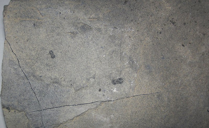
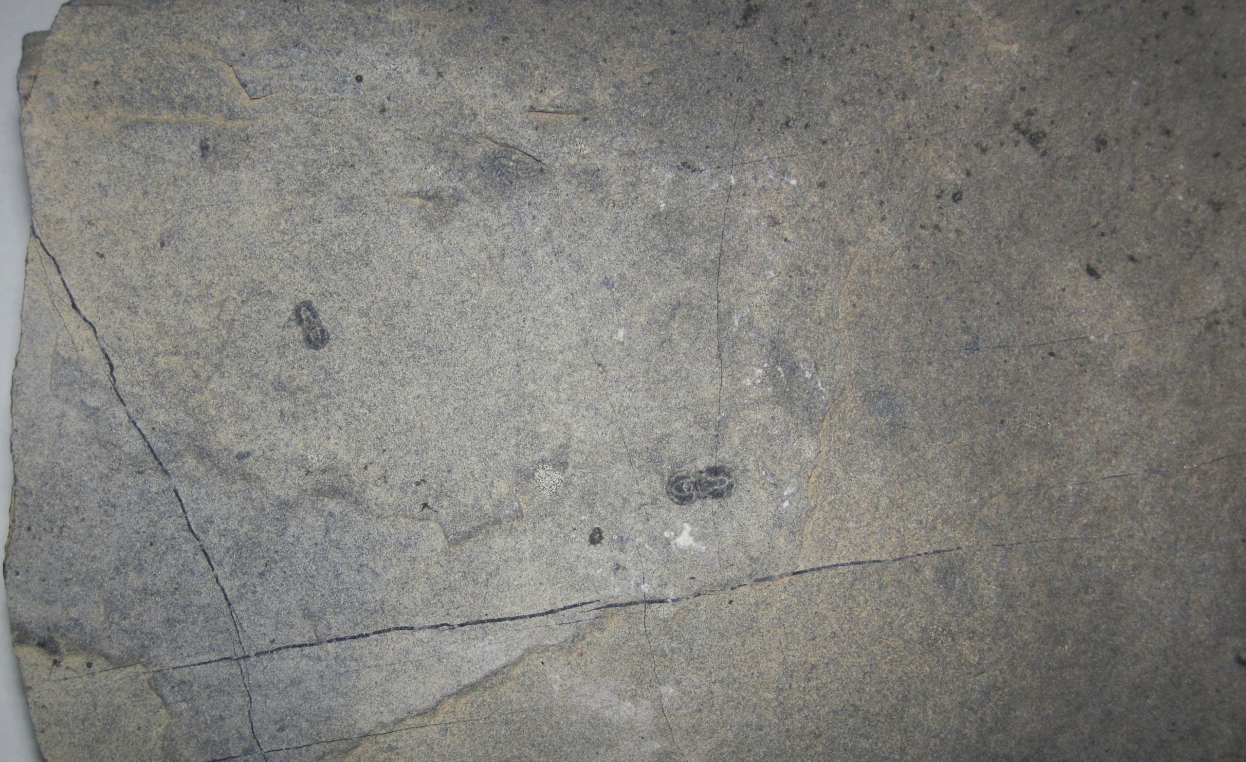
English: Agnostoid trilobites in lime mudstone from the Cambrian of Utah, USA.
Trilobites are extinct marine arthropods. They first appear in Lower Cambrian rocks and the entire group went extinct at the end of the Permian. Trilobites had a calcitic exoskeleton and nonmineralizing parts underneath (legs, gills, gut, etc.). The calcite skeleton is most commonly preserved in the fossil record, although soft-part preservation is known in some trilobites (Ex: Burgess Shale and Hunsruck Slate). Trilobites had a head (cephalon), a body of many segments (thorax), and a tail (pygidium). Molts and carcasses usually fell apart quickly - most trilobite fossils are isolated parts of the head (cranidium and free cheeks), individual thoracic segments, or isolated pygidia. The name "trilobite" was introduced in 1771 by Johann Ernst Immanuel Walch and refers to the tripartite division of the trilobite body - it has a central axial lobe that runs longitudinally from the head to the tail, plus two side lobes (pleural lobes). The two small, dark-colored, dumbbell-shaped fossils seen above are agnostoid trilobites. Agnostoids differ from "ordinary" trilobites (= polymeroids) by having the following characeristics: two-segmented thorax; blind (no eyes); isopygous (the heads & tails are equal-sized). Agnostoids are usually quite small. Many modern arthropod phylogenetic studies conclude that agnostoids should be excluded from the trilobites. Classification: Animalia, Arthropoda, Trilobita, Agnostida Stratigraphy: Wheeler Formation, upper part of the Ptychagnostus gibbus Interval-zone, middle Middle Cambrian Locality: northeast-southwest trending ridge crest in the SE1/4 of Section 17, 52 mm N, 33 mm E of the southwestern corner of the Drum Mountains Well 1:24,000 quadrangle map, southeastern end of the Drum Mountains, northern Millard County, western Utah, USA (= stop 2 in Laurentia 99 field trip guidebook) (vicinity of 39˚ 30' 46.60" North latitude, 112˚ 59' 24.05" West longitude) Reference: International Subcommission on Cambrian Stratigraphy. 1999. Laurentia 99, V Field Conference of the Cambrian Stage Subdivision Working Group, Utah, Nevada, California, USA, 12-22 September 1999. 65 pp. |
| Date | |
| Source | https://www.flickr.com/photos/47445767@N05/49057475118/ |
| Author | James St. John |
Licensing
[edit].jpg&action=edit§ion=2)
- You are free:
- to share – to copy, distribute and transmit the work
- to remix – to adapt the work
- Under the following conditions:
- attribution – You must give appropriate credit, provide a link to the license, and indicate if changes were made. You may do so in any reasonable manner, but not in any way that suggests the licensor endorses you or your use.
| This image was originally posted to Flickr by James St. John at https://flickr.com/photos/47445767@N05/49057475118. It was reviewed on 13 October 2020 by FlickreviewR 2 and was confirmed to be licensed under the terms of the cc-by-2.0. |
File history
Click on a date/time to view the file as it appeared at that time.
| Date/Time | Thumbnail | Dimensions | User | Comment | |
|---|---|---|---|---|---|
| current | 01:54, 13 October 2020 | | 3,751 × 2,295 (6.3 MB) | Ser Amantio di Nicolao (talk | contribs) | Uploaded a work by James St. John from https://www.flickr.com/photos/47445767@N05/49057475118/ with UploadWizard |
You cannot overwrite this file.
File usage on Commons
There are no pages that use this file.
.jpg&oldid=896729662)