File:Aghlabids Dynasty 800 - 909 (AD).svg
Jump to navigation
Jump to search

Size of this PNG preview of this SVG file: 667 × 459 pixels. Other resolutions: 320 × 220 pixels | 640 × 440 pixels | 1,024 × 705 pixels | 1,280 × 881 pixels | 2,560 × 1,762 pixels.
Original file (SVG file, nominally 667 × 459 pixels, file size: 92 KB)
Captions
Captions
Add a one-line explanation of what this file represents
Summary
[edit]| Description |
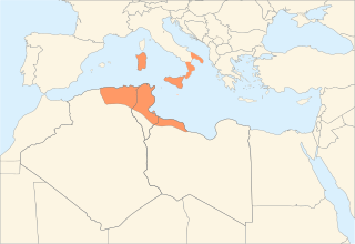
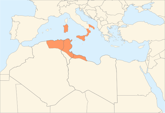
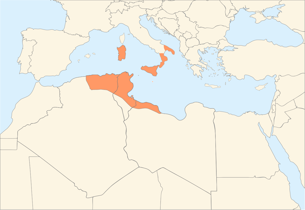
Français : Carte de l'extension maximale du royaume des Aghlabides. العربية: خريطة تظهر الدَّولة الأغلبيَّة في أقصى اتساعها، بين 800 و909 م. |
| Date | 22 April 2008 (original upload date) |
| Source |
Transferred from fr.wikipedia to Commons. Français : Travail personnel Update based on: Atlas of Islamic History, page 24 |
| Author | The original uploader was Nanoxyde at French Wikipedia. |
| Other versions |
|
_-_Arabic.svg)
.svg&action=edit§ion=1)
Licensing
[edit].svg&action=edit§ion=2)
This file is licensed under the Creative Commons Attribution-Share Alike 2.5 Generic license.
- You are free:
- to share – to copy, distribute and transmit the work
- to remix – to adapt the work
- Under the following conditions:
- attribution – You must give appropriate credit, provide a link to the license, and indicate if changes were made. You may do so in any reasonable manner, but not in any way that suggests the licensor endorses you or your use.
- share alike – If you remix, transform, or build upon the material, you must distribute your contributions under the same or compatible license as the original.
Original upload log
[edit].svg&action=edit§ion=3)
The original description page was here. All following user names refer to fr.wikipedia.
- 2008-05-01 02:08 Nanoxyde 666×458×0 (142139 bytes) corrections
- 2008-04-30 02:38 Nanoxyde 571×428×0 (141323 bytes) problème famille de police
- 2008-04-30 02:33 Nanoxyde 571×428×0 (141072 bytes) cadrage, précision des tracés
- 2008-04-22 17:09 Nanoxyde 794×420×0 (46116 bytes) {{Image de travail}} Travail personnel
File history
Click on a date/time to view the file as it appeared at that time.
.svg&dir=prev)
.svg&offset=20220221215653)
.svg&offset=&limit=20)
.svg&offset=&limit=50)
.svg&offset=&limit=100)
.svg&offset=&limit=250)
.svg&offset=&limit=500)
| Date/Time | Thumbnail | Dimensions | User | Comment | |
|---|---|---|---|---|---|
| current | 13:05, 17 October 2023 | | 667 × 459 (92 KB) | M.Bitton (talk | contribs) | Reverted to version as of 15:13, 30 August 2023 (UTC): per COM:OVERWRITE + discussed ad nauseam |
| 00:35, 17 October 2023 |  | 667 × 459 (98 KB) | Daygum (talk | contribs) | Correct map without the island of Sardinia which has never been under aghlabid rule | |
| 15:13, 30 August 2023 |  | 667 × 459 (92 KB) | M.Bitton (talk | contribs) | Reverted to version as of 11:14, 6 October 2022 (UTC): stop edit warring or you'll be reported to the admins | |
| 13:24, 30 August 2023 |  | 667 × 459 (98 KB) | Skyfall (talk | contribs) | Reverted to version as of 07:53, 6 October 2022 (UTC): as explained L2212 before in the description and as the discussion page | |
| 11:14, 6 October 2022 |  | 667 × 459 (92 KB) | M.Bitton (talk | contribs) | Reverted to version as of 15:40, 23 April 2022 (UTC):having failed to achieve consensus on en.wp for your POV, you are now introducing it through the back door | |
| 07:53, 6 October 2022 |  | 667 × 459 (98 KB) | L2212 (talk | contribs) | Fixing the text | |
| 07:49, 6 October 2022 |  | 667 × 459 (98 KB) | L2212 (talk | contribs) | Fixing the map to avoid misinterpretation. The source never puts all of these areas in the same category, therefore doing that is original research and POV pushing. Both Sardinia and Southern Italy are colored differently compared to Northern Africa or Sicily, and they are also different from each other. In the same page of the book used as a source, the authors actually wrote "''The Aghlabids ruled more or less independently until the Fatimid conquest in 909, initiating an Arab occupation of... | |
| 15:40, 23 April 2022 |  | 667 × 459 (92 KB) | M.Bitton (talk | contribs) | Reverted to version as of 21:56, 21 February 2022 (UTC): the cited source says otherwise | |
| 12:23, 23 April 2022 |  | 667 × 459 (98 KB) | Daygum (talk | contribs) | Aghlabites didn't settle in Sardinia and they haven't ruled the island in its history. it didn't exist traces of their presence on the island and nobody knows names of some arab governors- | |
| 21:56, 21 February 2022 |  | 667 × 459 (92 KB) | M.Bitton (talk | contribs) | Reverted to version as of 00:31, 20 February 2022 (UTC): see the cited source |
You cannot overwrite this file.
File usage on Commons
The following 2 pages use this file:
File usage on other wikis
The following other wikis use this file:
- Usage on de.wikipedia.org
- Usage on en.wikipedia.org
- Usage on fa.wikipedia.org
- Usage on fr.wikipedia.org
- Histoire de la Tunisie
- Histoire de la Libye
- Discussion utilisateur:Nanoxyde/Archives 04
- Wikipédia:Atelier graphique/Cartes/Archives/mai 2008
- Wikipédia:Atelier graphique/Images à améliorer/Archives/Mai 2008
- Discussion utilisateur:Moez/archive17
- Modèle:Infobox Religion
- Modèle:Infobox Religion/Documentation
- Usage on id.wikibooks.org
- Usage on ja.wikipedia.org
- Usage on ko.wikipedia.org
- Usage on lt.wikipedia.org
- Usage on ms.wikipedia.org
- Usage on nl.wikipedia.org
- Usage on no.wikipedia.org
- Usage on ro.wikipedia.org
- Usage on sr.wikipedia.org
- Usage on sv.wikipedia.org
- Usage on tum.wikipedia.org
.svg&oldid=931166716)