File:African Zoar Methodist Episcopal Church historical marker at 401 Brown St Philadelphia PA (DSC 4500) (cropped).jpg
From Wikimedia Commons, the free media repository
Jump to navigation
Jump to search
![File:African Zoar Methodist Episcopal Church historical marker at 401 Brown St Philadelphia PA (DSC 4500) (cropped).jpg](https://upload.wikimedia.org/wikipedia/commons/thumb/e/e1/African_Zoar_Methodist_Episcopal_Church_historical_marker_at_401_Brown_St_Philadelphia_PA_%28DSC_4500%29_%28cropped%29.jpg/582px-African_Zoar_Methodist_Episcopal_Church_historical_marker_at_401_Brown_St_Philadelphia_PA_%28DSC_4500%29_%28cropped%29.jpg?20240229014007)
Size of this preview: 582 × 599 pixels. Other resolutions: 233 × 240 pixels | 466 × 480 pixels | 746 × 768 pixels | 1,200 × 1,235 pixels.
Original file (1,200 × 1,235 pixels, file size: 1.12 MB, MIME type: image/jpeg)
File information
Structured data
Captions
Captions
Add a one-line explanation of what this file represents
Summary
[edit]DescriptionAfrican Zoar Methodist Episcopal Church historical marker at 401 Brown St Philadelphia PA (DSC 4500) (cropped).jpg |
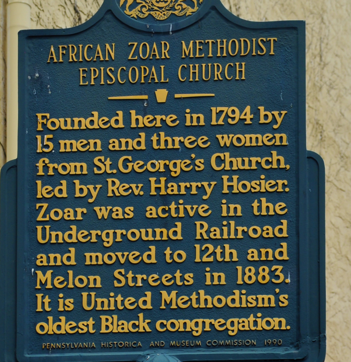
English: African Zoar Methodist Episcopal Church - Founded here in 1794 by 15 men and three women from St. George's Church, led by Rev. Harry Hosier. Zoar was active in the Underground Railroad and moved to 12th and Melon Streets in 1883. It is United Methodism's oldest Black congregation. (Historical marker located at 401 Brown St. Philadelphia PA - Pennsylvania Historical and Museum Commission 1990) |
|||
Date | ||||
Source | Own work | |||
Author | NMGiovannucci | |||
Other versions |
|
Camera location | 39° 57′ 49.91″ N, 75° 08′ 41.45″ W ![]() ![]() | View this and other nearby images on: OpenStreetMap | ![]() |
---|
Licensing
[edit]I, the copyright holder of this work, hereby publish it under the following license:
![w:en:Creative Commons](https://upload.wikimedia.org/wikipedia/commons/thumb/7/79/CC_some_rights_reserved.svg/90px-CC_some_rights_reserved.svg.png)
![attribution](https://upload.wikimedia.org/wikipedia/commons/thumb/1/11/Cc-by_new_white.svg/24px-Cc-by_new_white.svg.png)
![share alike](https://upload.wikimedia.org/wikipedia/commons/thumb/d/df/Cc-sa_white.svg/24px-Cc-sa_white.svg.png)
This file is licensed under the Creative Commons Attribution-Share Alike 4.0 International license.
- You are free:
- to share – to copy, distribute and transmit the work
- to remix – to adapt the work
- Under the following conditions:
- attribution – You must give appropriate credit, provide a link to the license, and indicate if changes were made. You may do so in any reasonable manner, but not in any way that suggests the licensor endorses you or your use.
- share alike – If you remix, transform, or build upon the material, you must distribute your contributions under the same or compatible license as the original.
File history
Click on a date/time to view the file as it appeared at that time.
Date/Time | Thumbnail | Dimensions | User | Comment | |
---|---|---|---|---|---|
current | 01:40, 29 February 2024 | ![]() | 1,200 × 1,235 (1.12 MB) | Krok6kola (talk | contribs) | Cropped 20 % horizontally, 20 % vertically using CropTool with lossless mode. |
18:59, 28 February 2024 | ![]() | 1,494 × 1,541 (1.56 MB) | Krok6kola (talk | contribs) | File:African Zoar Methodist Episcopal Church historical marker at 401 Brown St Philadelphia PA (DSC 4500).jpg cropped 50 % horizontally, 23 % vertically using CropTool with lossless mode. |
You cannot overwrite this file.
File usage on Commons
The following page uses this file:
Metadata
This file contains additional information such as Exif metadata which may have been added by the digital camera, scanner, or software program used to create or digitize it. If the file has been modified from its original state, some details such as the timestamp may not fully reflect those of the original file. The timestamp is only as accurate as the clock in the camera, and it may be completely wrong.
Image title |
|
---|---|
Camera manufacturer | NIKON CORPORATION |
Camera model | NIKON D5000 |
Author | NMGiovannucci |
Copyright holder |
|
Exposure time | 1/200 sec (0.005) |
F-number | f/7.1 |
ISO speed rating | 200 |
Date and time of data generation | 14:55, 9 October 2021 |
Lens focal length | 42 mm |
Latitude | 39° 57′ 49.91″ N |
Longitude | 75° 8′ 41.45″ W |
Altitude | 47 meters above sea level |
Online copyright statement | https://creativecommons.org/licenses/by/4.0/ |
Short title |
|
Width | 3,216 px |
Height | 2,136 px |
Bits per component |
|
Pixel composition | RGB |
Orientation | Normal |
Number of components | 3 |
Horizontal resolution | 300 dpi |
Vertical resolution | 300 dpi |
Software used | Adobe Photoshop CS5 Windows |
File change date and time | 15:08, 3 January 2022 |
Y and C positioning | Co-sited |
Exposure Program | Not defined |
Exif version | 2.21 |
Date and time of digitizing | 14:55, 9 October 2021 |
Meaning of each component |
|
Image compression mode | 4 |
APEX shutter speed | 7.643856 |
APEX aperture | 5.655638 |
APEX exposure bias | 0 |
Maximum land aperture | 4.8 APEX (f/5.28) |
Subject distance | 4,294,967,295 meters |
Metering mode | Pattern |
Light source | Unknown |
Flash | Flash did not fire, auto mode |
DateTime subseconds | 50 |
DateTimeOriginal subseconds | 50 |
DateTimeDigitized subseconds | 50 |
Supported Flashpix version | 1 |
Color space | sRGB |
Sensing method | One-chip color area sensor |
File source | Digital still camera |
Scene type | A directly photographed image |
Custom image processing | Normal process |
Exposure mode | Auto exposure |
White balance | Auto white balance |
Digital zoom ratio | 1 |
Focal length in 35 mm film | 63 mm |
Scene capture type | Standard |
Scene control | None |
Contrast | Normal |
Saturation | Normal |
Sharpness | Normal |
Subject distance range | Unknown |
GPS time (atomic clock) | 19:23 |
Satellites used for measurement | 05 |
Reference for direction of image | Magnetic direction |
Direction of image | 83.48 |
Geodetic survey data used | WGS 84 |
GPS date | 9 October 2021 |
GPS tag version | 2.2.0.0 |
Serial number of camera | 3598758 |
Lens used | 18.0-55.0 mm f/3.5-5.6 |
Date metadata was last modified | 10:08, 3 January 2022 |
Copyright status | Copyrighted |
Unique ID of original document | xmp.did:3F83A721C46CEC119262A6594F51E3B2 |
Structured data
Items portrayed in this file
depicts
image/jpeg
05fb01ff3710717e987670939bb33a9621fa60eb
1,640,985 byte
1,541 pixel
1,494 pixel
39°57'49.907"N, 75°8'41.449"W
9 October 2021
0.005 second
7.1
42 millimetre
200
Categories:
- Pennsylvania state historical markers in Philadelphia
- African Methodist Episcopal churches in Pennsylvania
- Underground Railroad in Philadelphia
- African American history of Pennsylvania
- St. George's United Methodist Church (Philadelphia)
- 1794 in Philadelphia
- 4th Street (Philadelphia)
- Brown Street (Philadelphia)
- 1883 in Philadelphia