File:Africa de l'Oèst (fin sègle XVIII).png
Jump to navigation
Jump to search

Size of this preview: 800 × 397 pixels. Other resolutions: 320 × 159 pixels | 640 × 318 pixels | 1,192 × 592 pixels.
Original file (1,192 × 592 pixels, file size: 172 KB, MIME type: image/png)
Captions
Captions
Add a one-line explanation of what this file represents
Summary
[edit].png&action=edit§ion=1)
| Description |
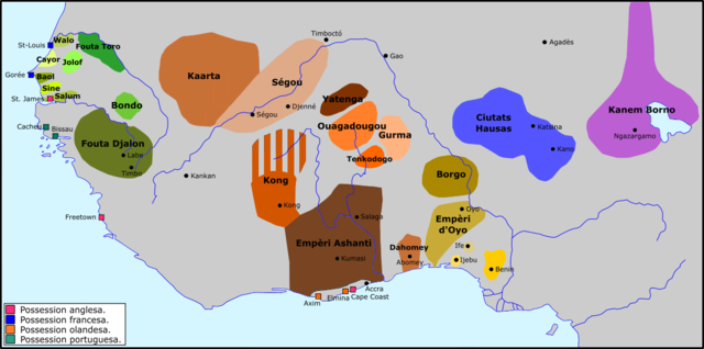
Occitan : Africa de l'Oèst a la fin dau sègle XVIII. |
| Date | |
| Source | Own work |
| Author | Nicolas Eynaud |
Licensing
[edit].png&action=edit§ion=2)
I, the copyright holder of this work, hereby publish it under the following license:
This file is licensed under the Creative Commons Attribution-Share Alike 4.0 International license.
- You are free:
- to share – to copy, distribute and transmit the work
- to remix – to adapt the work
- Under the following conditions:
- attribution – You must give appropriate credit, provide a link to the license, and indicate if changes were made. You may do so in any reasonable manner, but not in any way that suggests the licensor endorses you or your use.
- share alike – If you remix, transform, or build upon the material, you must distribute your contributions under the same or compatible license as the original.
File history
Click on a date/time to view the file as it appeared at that time.
| Date/Time | Thumbnail | Dimensions | User | Comment | |
|---|---|---|---|---|---|
| current | 12:47, 24 December 2015 | | 1,192 × 592 (172 KB) | Nicolas Eynaud (talk | contribs) | User created page with UploadWizard |
You cannot overwrite this file.
File usage on Commons
There are no pages that use this file.
File usage on other wikis
The following other wikis use this file:
- Usage on ar.wikipedia.org
- Usage on de.wikipedia.org
- Usage on en.wikipedia.org
- Usage on es.wikipedia.org
- Usage on fi.wikipedia.org
- Usage on fr.wikipedia.org
- Usage on it.wikipedia.org
- Usage on nqo.wikipedia.org
- Usage on oc.wikipedia.org
- Usage on ru.wikipedia.org
- Usage on sv.wikipedia.org
- Usage on sw.wikipedia.org
- Usage on uk.wikipedia.org
- Usage on vi.wikipedia.org
Metadata
.png&oldid=873545782)
Categories:
- Maps of the history of Mauritania
- Maps of the history of Senegal
- Maps of the history of the Gambia
- Maps of the history of Liberia
- Maps of the history of Guinea
- Maps of the history of Sierra Leone
- Maps of the history of Ghana
- Maps of the history of Togo
- Maps of the history of Benin
- Maps of the history of Nigeria
- Maps of the history of Chad
- Maps of the history of Niger
- Maps of the history of Burkina Faso
- Maps of the history of Ivory Coast
- Maps of 18th-century Africa
- Futa Tooro
- Kong Empire