File:Africa1850s.png
Jump to navigation
Jump to search

Size of this preview: 619 × 600 pixels. Other resolutions: 248 × 240 pixels | 495 × 480 pixels | 640 × 620 pixels.
Original file (640 × 620 pixels, file size: 170 KB, MIME type: image/png)
Captions
Captions
Add a one-line explanation of what this file represents

|
File:Africa 1850s.svg is a vector version of this file. It should be used in place of this PNG file when not inferior.
File:Africa1850s.png → File:Africa 1850s.svg
For more information, see Help:SVG. |
 |
NB: Feel free to edit this picture and make it more attractive.--Tiresais (talk) 13:34, 4 February 2011 (UTC)
| Description |
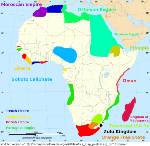
English: Map of Africa during 1850s. Lambert azimutal equal-area projection, WGS84 datum, standard meridian: 15°E, standard parallel: 0°Scale: 1:15,000,000 (accuracy: 3,75 km) |
| Date | (UTC) |
| Source | |
| Author |
|
| This is a retouched picture, which means that it has been digitally altered from its original version. Modifications: Addition of Nations during 1850s. The original can be viewed here: Africa map political.svg:
|
I, the copyright holder of this work, hereby publish it under the following licenses:
This file is licensed under the Creative Commons Attribution-Share Alike 2.5 Generic, 2.0 Generic and 1.0 Generic license.
- You are free:
- to share – to copy, distribute and transmit the work
- to remix – to adapt the work
- Under the following conditions:
- attribution – You must give appropriate credit, provide a link to the license, and indicate if changes were made. You may do so in any reasonable manner, but not in any way that suggests the licensor endorses you or your use.
- share alike – If you remix, transform, or build upon the material, you must distribute your contributions under the same or compatible license as the original.
| This file is licensed under the Creative Commons Attribution-Share Alike 3.0 Unported license. | ||
| ||
| This licensing tag was added to this file as part of the GFDL licensing update. |

|
Permission is granted to copy, distribute and/or modify this document under the terms of the GNU Free Documentation License, Version 1.2 or any later version published by the Free Software Foundation; with no Invariant Sections, no Front-Cover Texts, and no Back-Cover Texts. A copy of the license is included in the section entitled GNU Free Documentation License. |
You may select the license of your choice.
Original upload log
[edit]
This image is a derivative work of the following images:
- File:Africa_map_political.svg licensed with Cc-by-sa-2.5,2.0,1.0, Cc-by-sa-3.0-migrated, GFDL
- 2009-01-10T20:41:36Z Sting 1525x1440 (711752 Bytes) Detail correction
- 2008-06-27T23:15:10Z Sting 1525x1440 (713139 Bytes) Completely new drawing with known projection ; new colors
- 2006-09-21T20:58:44Z Sting 1390x1295 (571753 Bytes) Colours
- 2006-05-31T21:17:07Z Sting 1390x1295 (571018 Bytes) {{Information |Description=Blank political vector graphic map of [[:Category:Maps of Africa|Africa]] |Source=Several bitmap-type maps |Date= May 2006 |Author= Eric Gaba ([[User:Sting|Sting]]) |Permission=GFDL or CC-BY-SA |oth
Uploaded with derivativeFX
File history
Click on a date/time to view the file as it appeared at that time.
| Date/Time | Thumbnail | Dimensions | User | Comment | |
|---|---|---|---|---|---|
| current | 13:32, 4 February 2011 | | 640 × 620 (170 KB) | Tiresais~commonswiki (talk | contribs) | {{Information |Description={{en|Map of Africa during 1850s.}} Lambert azimutal equal-area projection, WGS84 datum, standard meridian: 15°E, standard parallel: 0°<br/> Scale: 1:15,000,000 (accuracy: 3,75 km) |Source=*[[:File: |
You cannot overwrite this file.
File usage on Commons
There are no pages that use this file.
File usage on other wikis
The following other wikis use this file:
- Usage on af.wikipedia.org