File:Aerial view of northwestern community of Baileys Harbor, southeastern town of Gibraltar, and northwestern town of Baileys Harbor, Door County, Wisconsin 2020.png

Original file (9,154 × 12,495 pixels, file size: 219.68 MB, MIME type: image/png)
Captions
Captions
| Warning | The original file is very high-resolution. It might not load properly or could cause your browser to freeze when opened at full size. |
|---|
| Description |
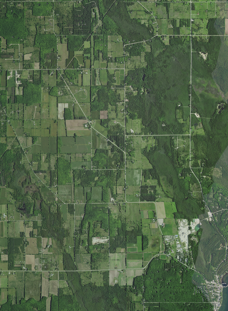
Aerial view of the northern and northwestern community of Baileys Harbor (far lower right) in Door County, Wisconsin, taken June 27, 2020. Somewhat more than half of the photo is in the town of Baileys Harbor (the right side, and also the entire left and right side near the bottom), but a small portion at the top side on the right depicts the southern edge of the town of Liberty Grove. The town border is marked in part by Grove Road (upper right). Most of the left side depicts the southeast town of Gibraltar, but the lower portion is in Baileys Harbor. Piel Creek (lower left) flows south into Kangaroo Lake. Hidden Brook (lower right) flows into the harbor of Baileys Harbor (far lower right). An unnamed creek (right, above the center) flows east into Mud Lake. Recreational areas include part of the Baileys Harbor Boreal Forest and Wetlands are recognized protected areas under the Ramsar Convention. It is partly owned by the Nature Conservancy. Other protected areas open to the public include the Ridges Sanctuary, and the Wisconsin DNR-owned part of the Baileys Harbor Boreal Forest And Wetlands State Natural Area and Mud Lake Wildlife Area. For other partial views of the community of Baileys Harbor, see File:Aerial view of the northern part of the community of Baileys Harbor, southern North Bay, Mud Lake, Moonlight Bay, and the northern harbor of Baileys Harbor in the town of Baileys Harbor, Door County, Wisconsin 2020.png and also File:Aerial view of the southern and central community of Baileys Harbor and vicinity in Door County, Wisconsin 2020 (cropped).png, cropped from File:Aerial view of Kangaroo Lake in the towns of Jacksonport and Baileys Harbor, Door County, Wisconsin 2020.png. Coordinates:
|
|||
| Date | ||||
| Source | converted to .png by Epiphyllumlover from the original .tif available as item M_4508763_NE_16_060_20200627 on EarthExplorer | |||
| Author | Aerial Photography Field Office (APFO) for NAIP, USGS; in contract with the Surdex Corporation | |||
| Permission (Reusing this file) |
|
.png)
File history
Click on a date/time to view the file as it appeared at that time.
| Date/Time | Thumbnail | Dimensions | User | Comment | |
|---|---|---|---|---|---|
| current | 18:56, 12 March 2022 | | 9,154 × 12,495 (219.68 MB) | Epiphyllumlover (talk | contribs) | c:User:Rillke/bigChunkedUpload.js: {{Information | Description = Aerial view of the northern and northwestern community of Baileys Harbor (far lower right) in Door County, Wisconsin, taken June 27, 2020. Somewhat more than half of the photo is in the town of Baileys Harbor (the right side, and also the entire left and right side near the bottom), but a small portion at the top side on... |
You cannot overwrite this file.
File usage on Commons
There are no pages that use this file.