File:Aerial view of Bay Farm Island Bridge in 2009.jpg
Jump to navigation
Jump to search

Size of this preview: 800 × 496 pixels. Other resolutions: 320 × 199 pixels | 640 × 397 pixels | 1,024 × 635 pixels | 1,439 × 893 pixels.
Original file (1,439 × 893 pixels, file size: 430 KB, MIME type: image/jpeg)
Captions
Captions
Add a one-line explanation of what this file represents
Summary
[edit]| Description |
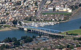
English: Aerial photo, from the southwest, of Bay Farm Island Bridge, a 1953 single-leaf bascule bridge crossing San Leandro Channel from Bay Farm Island (bottom) to Alameda Island (top) in Alameda, California, in the Oakland metropolitan area. |
| Date | |
| Source | |
| Author | Dcoetzee |

| Camera location | | View this and other nearby images on: OpenStreetMap |
|---|
Licensing
[edit]
| I, the copyright holder of this work, release this work into the public domain. This applies worldwide. In some countries this may not be legally possible; if so: I grant anyone the right to use this work for any purpose, without any conditions, unless such conditions are required by law. |
File history
Click on a date/time to view the file as it appeared at that time.
| Date/Time | Thumbnail | Dimensions | User | Comment | |
|---|---|---|---|---|---|
| current | 10:16, 6 April 2017 | | 1,439 × 893 (430 KB) | Steve Morgan (talk | contribs) | == {{int:filedesc}} == {{Information |Description={{en|1=Aerial photo, from the southwest, of Bay Farm Island Bridge, a 1953 bascule bridge crossing San Leandro Channel from Bay Farm Island (bottom) to Alameda Island (top) in Oakland, California.}} |So... |
You cannot overwrite this file.
File usage on Commons
The following 2 pages use this file:
File usage on other wikis
The following other wikis use this file:
- Usage on en.wikipedia.org
- Usage on www.wikidata.org