File:Aerial photographs of Imaicho.jpg
Jump to navigation
Jump to search
No higher resolution available.
Aerial_photographs_of_Imaicho.jpg (600 × 600 pixels, file size: 238 KB, MIME type: image/jpeg)
Captions
Captions
Add a one-line explanation of what this file represents
Aerial_photographs_of_Imaicho
en
[edit]
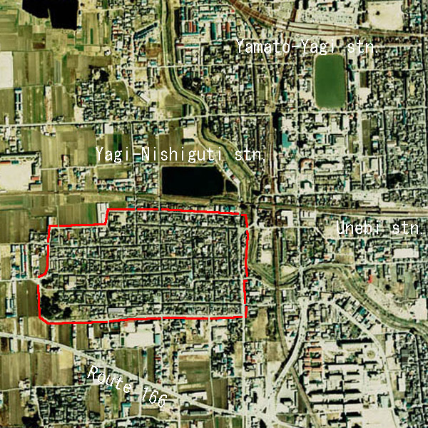
| Description |
Area of Imai-cho (inside of red line), Important Preservation Districts for Groups of Historic Buildings Kashihara-shi Nara-Pref.,Japan. |
| Date | Original AerialPhotograph : 1974 ( modifyed in 2006-11-26) |
| Source | CKK-74-7 C46B-6 in 1974,AerialPhotograph-mlitJP |
| Author | Tawashi2006 |
| Permission (Reusing this file) |
AerialPhotograph-mlitJP |
ja
[edit]
| Description |
重要伝統的建造物群保存地区今井町の範囲(赤線内) 奈良県橿原市 |
| Date | |
| Source | 国土情報航空写真(国土地理院)1974年度撮影 CKK-74-7 C46B-6 |
| Author | Tawashi2006 |
| Permission (Reusing this file) |
AerialPhotograph-mlitJP |

|
The copyright holder of this file, the Ministry of Land, Infrastructure, Transport and Tourism of Japan, allows anyone to use it for any purpose, provided that the copyright holder is properly attributed. Redistribution, derivative work, commercial use, and all other use is permitted. |
Attribution:
Copyright © National Land Image Information (Color Aerial Photographs), Ministry of Land, Infrastructure, Transport and Tourism
|
 |
This image is copyrighted by the Ministry of Land, Infrastructure, Transport and Tourism of Japan. For terms of use, see the stipulation to use of National Land Information (in Japanese) and message from MLIT (in Japanese and English). When you display this image on an article, include the following phrase in the description: "Made based on National Land Image Information (Color Aerial Photographs), Ministry of Land, Infrastructure, Transport and Tourism".
|
File history
Click on a date/time to view the file as it appeared at that time.
| Date/Time | Thumbnail | Dimensions | User | Comment | |
|---|---|---|---|---|---|
| current | 02:27, 26 November 2006 | | 600 × 600 (238 KB) | Tawashi2006 (talk | contribs) | Aerial_photographs_of_Imaicho ===en=== {{Information| |Description = Area of Imai-cho (inside of red line),<br>Important Preservation Districts for Groups of Historic Buildings<br>Kashihara-shi Nara-Pref.,Japan. |Source = CKK-74-7 C46B-6 in 1974,AerialPho |
You cannot overwrite this file.
File usage on Commons
The following page uses this file:
File usage on other wikis
The following other wikis use this file: