File:Aerial photo from 1920 of modern-day Falcon Heights, Minnesota.jpg
Jump to navigation
Jump to search

Size of this preview: 648 × 600 pixels. Other resolutions: 259 × 240 pixels | 519 × 480 pixels | 830 × 768 pixels | 1,125 × 1,041 pixels.
Original file (1,125 × 1,041 pixels, file size: 666 KB, MIME type: image/jpeg)
Captions
Captions
Add a one-line explanation of what this file represents
Summary
[edit]
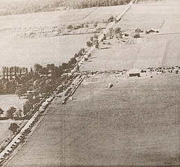
| Description | Snelling and Larpenteur Avenues with the Quinn farm and Curtiss Northwest Airport |
| Date | |
| Source | St. Anthony Park/Falcon Heights/Lauderdale/Como Park Park Bugle. May 2017. Page 7. www.parkbugle.org. Reproduced from the Minnesota Aviation Hall of Fame. |
| Author | Runner1928 |
Licensing
[edit]
This work is in the public domain in the United States because it was published (or registered with the U.S. Copyright Office) before January 1, 1929.
Public domain works must be out of copyright in both the United States and in the source country of the work in order to be hosted on the Commons. If the work is not a U.S. work, the file must have an additional copyright tag indicating the copyright status in the source country.
Note: This tag should not be used for sound recordings. |
| This file was uploaded via Mobile Android App (Commons mobile app) 2.2.2. |
File history
Click on a date/time to view the file as it appeared at that time.
| Date/Time | Thumbnail | Dimensions | User | Comment | |
|---|---|---|---|---|---|
| current | 15:54, 23 April 2017 | | 1,125 × 1,041 (666 KB) | Runner1928 (talk | contribs) | Uploaded using Android Commons app |
You cannot overwrite this file.
File usage on Commons
The following page uses this file:
File usage on other wikis
The following other wikis use this file:
- Usage on en.wikipedia.org