File:Aerial of 106th Street Bridge Chicago from NE in 1999.jpg
Jump to navigation
Jump to search

Size of this preview: 800 × 548 pixels. Other resolutions: 320 × 219 pixels | 640 × 438 pixels | 1,024 × 701 pixels | 1,280 × 876 pixels | 2,560 × 1,753 pixels | 2,997 × 2,052 pixels.
Original file (2,997 × 2,052 pixels, file size: 1.53 MB, MIME type: image/jpeg)
Captions
Captions
Add a one-line explanation of what this file represents
Summary
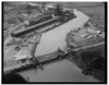
[edit]| Description | The 106th Street Bridge, in Chicago – aerial view from the northeast. The bridge is a 1928 double-leaf bascule bridge carrying East 106th Street over the Calumet River. | |||
| Date | ||||
| Source | ||||
| Author | Jet Lowe | |||
| Permission (Reusing this file) |
|
| Camera location | | View this and other nearby images on: OpenStreetMap |
|---|
Licensing
[edit]
This work is in the public domain in the United States because it is a work prepared by an officer or employee of the United States Government as part of that person’s official duties under the terms of Title 17, Chapter 1, Section 105 of the US Code.
Note: This only applies to original works of the Federal Government and not to the work of any individual U.S. state, territory, commonwealth, county, municipality, or any other subdivision. This template also does not apply to postage stamp designs published by the United States Postal Service since 1978. (See § 313.6(C)(1) of Compendium of U.S. Copyright Office Practices). It also does not apply to certain US coins; see The US Mint Terms of Use.
|
 | |
| This file has been identified as being free of known restrictions under copyright law, including all related and neighboring rights. | ||
File history
Click on a date/time to view the file as it appeared at that time.
| Date/Time | Thumbnail | Dimensions | User | Comment | |
|---|---|---|---|---|---|
| current | 07:27, 8 July 2018 | | 2,997 × 2,052 (1.53 MB) | Steve Morgan (talk | contribs) | {{Information |Description=The 106th Street Bridge, in Chicago – aerial view from the northeast. The bridge is a 1928 double-leaf bascule bridge carrying East 106th Street over the Calumet River. |Source={{extracted from|AERIAL VIEW, LOOKING SSW. - 106th Street Bridge, Spanning Calumet River at East 106th Street, Chicago, Cook County, IL HAER ILL,16-CHIG,111-2.tif}} |Date=1999 |Author=Jet Lowe |Permission= {{PD-USGov-NPS}} |other_versions= }} == {{int:license-header}} ... |
You cannot overwrite this file.
File usage on Commons
The following page uses this file:
File usage on other wikis
The following other wikis use this file:
- Usage on de.wikipedia.org