File:Aerial View of East Reading - geograph.org.uk - 713379.jpg
Jump to navigation
Jump to search
No higher resolution available.
Aerial_View_of_East_Reading_-_geograph.org.uk_-_713379.jpg (640 × 440 pixels, file size: 90 KB, MIME type: image/jpeg)
Captions
Captions
Add a one-line explanation of what this file represents
Summary
[edit]
| Description |
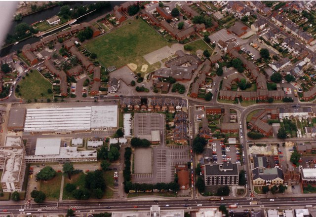
English: Aerial View of East Reading. Blake's lock on the Kennet & Avon Canal is in the top left of the image. The large white roof was part of the Reading College, which occupies the whole of the bottom left quadrant of the photograph, and the road behind this running left to right is Orts Road whilst the road at the bottom of the photo is the King's Road (A4). The square of grass in the upper centre is the playing field of St. John's school. |
| Date | |
| Source | From geograph.org.uk |
| Author | Antony Ewart Smith |
| Attribution (required by the license) | Antony Ewart Smith / Aerial View of East Reading / |
| Camera location | | View this and other nearby images on: OpenStreetMap |
|---|
_&language=en)
| Object location | | View this and other nearby images on: OpenStreetMap |
|---|
_&language=en)
Licensing
[edit]

|
This image was taken from the Geograph project collection. See this photograph's page on the Geograph website for the photographer's contact details. The copyright on this image is owned by Antony Ewart Smith and is licensed for reuse under the Creative Commons Attribution-ShareAlike 2.0 license.
|
This file is licensed under the Creative Commons Attribution-Share Alike 2.0 Generic license.
Attribution: Antony Ewart Smith
- You are free:
- to share – to copy, distribute and transmit the work
- to remix – to adapt the work
- Under the following conditions:
- attribution – You must give appropriate credit, provide a link to the license, and indicate if changes were made. You may do so in any reasonable manner, but not in any way that suggests the licensor endorses you or your use.
- share alike – If you remix, transform, or build upon the material, you must distribute your contributions under the same or compatible license as the original.
File history
Click on a date/time to view the file as it appeared at that time.
| Date/Time | Thumbnail | Dimensions | User | Comment | |
|---|---|---|---|---|---|
| current | 00:37, 19 February 2011 | | 640 × 440 (90 KB) | GeographBot (talk | contribs) | == {{int:filedesc}} == {{Information |description={{en|1=Aerial View of East Reading Blake's lock on the Kennet & Avon Canal is in the top left of the image. The large white roof was the Reading College building and the road behind this running left to ri |
You cannot overwrite this file.
File usage on Commons
There are no pages that use this file.