File:Admiralty Chart No 693 Whitby Harbour, (Maps SEC 1-698), Published 1895.jpg
Jump to navigation
Jump to search

Size of this preview: 800 × 595 pixels. Other resolutions: 320 × 238 pixels | 640 × 476 pixels | 1,024 × 762 pixels | 1,280 × 953 pixels | 2,560 × 1,906 pixels | 8,101 × 6,030 pixels.
Original file (8,101 × 6,030 pixels, file size: 7.59 MB, MIME type: image/jpeg)
Captions
Captions
Add a one-line explanation of what this file represents
| Description |
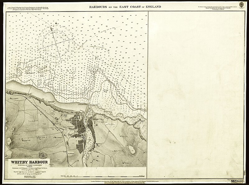
English: Harbours on the East Coast of England. (Whitby Harbour.) [Admiralty Chart]. Surveyed by Commr. G.E. Richards assisted by Lieutenants A.C. Williamson, J.F.Parry & Staff Commr. L.G. Stovin, H.M. Surveying Ship Triton, 1894. |
|||||||
| Date | ||||||||
| Source |
|
|||||||
| Permission (Reusing this file) |
|
|||||||
| Georeferencing | ||||||||
| Archival data | ||||||||
| Collection | ||||||||
| Accession number |
Maps SEC.1.(693) |
|||||||


File history
Click on a date/time to view the file as it appeared at that time.
| Date/Time | Thumbnail | Dimensions | User | Comment | |
|---|---|---|---|---|---|
| current | 22:20, 29 January 2014 | | 8,101 × 6,030 (7.59 MB) | LibraryBot (talk | contribs) | {{Artwork |artist = |title = |description = {{ en|1=Harbours on the East Coast of England. (Whitby Harbour.) [Admiralty Chart] }} |date = 1895 |medium = |dimensions = |institution... |
You cannot overwrite this file.
File usage on Commons
The following page uses this file:
- File:Whitby Harbour, Admiralty, 1895 (Maps SEC 1-698).jpg (file redirect)
.jpg&redirect=no)
,_Published_1895.jpg&oldid=871493542)