File:Admiralty Chart No 1575 Akaroa Harbour (16380266047), Surveyed 1849-1850.jpg

Original file (3,413 × 4,540 pixels, file size: 5.43 MB, MIME type: image/jpeg)
Captions
Captions
Summary
[edit],_Surveyed_1849-1850.jpg&action=edit§ion=1)
| Description |
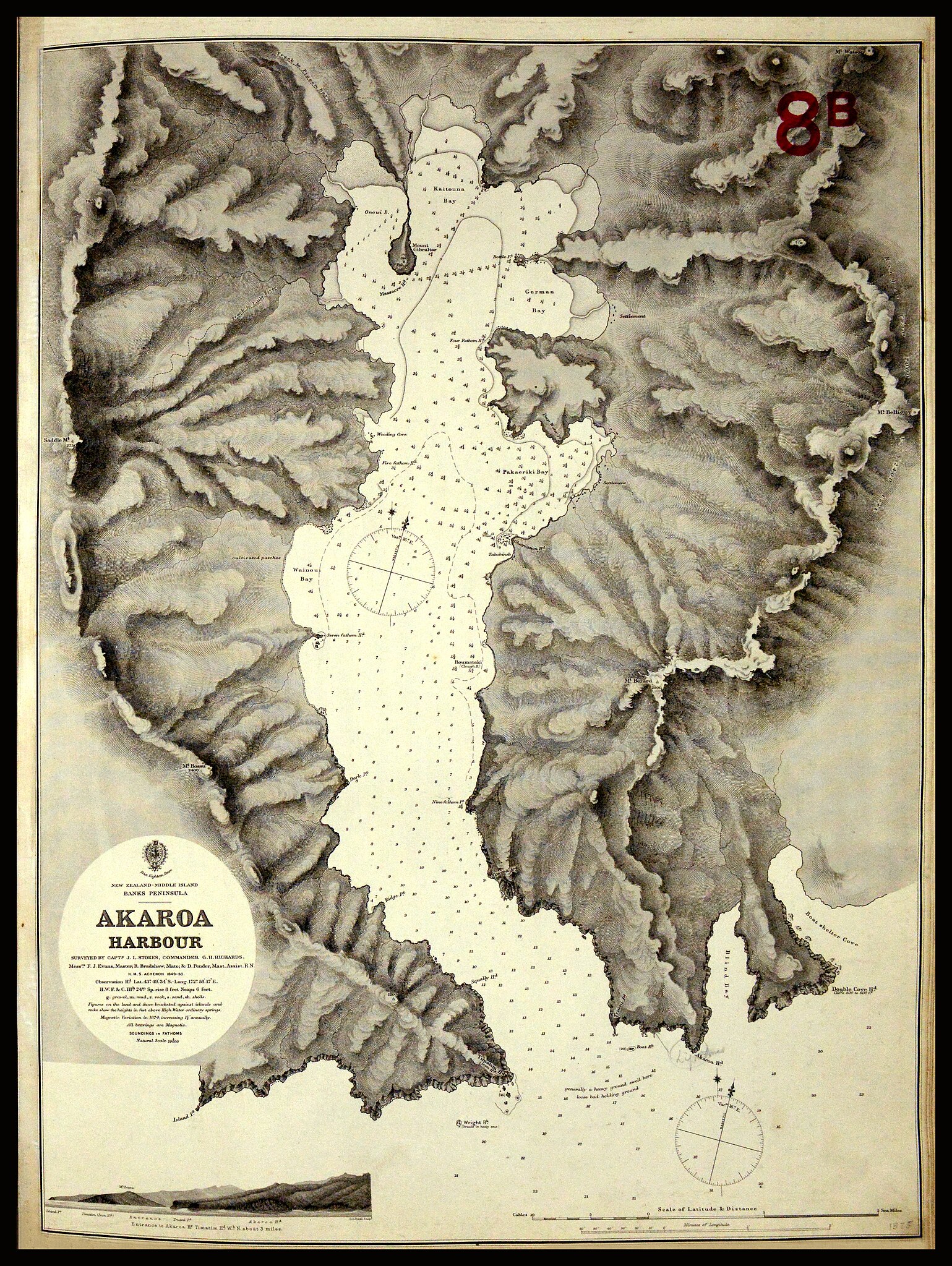
William Hobson gave Thomas Bunbury the task of gathering the signatures of rangatira in Te Waipounamu and Rakiura (the South and Stewart Islands). However, Hobson believed Māori in the southern regions were ‘wild savages’ and doubted their ability to observe ‘even the form of a treaty’. Because of this belief, Bunbury was given permission to proclaim sovereignty by right of ‘discovery’ if needed. After leaving Tauranga, Bunbury and Edward Williams sailed south on the HMS Herald. After a passage through heavy seas, they anchored at Akaroa Heads on 24 May. Here the Herald sat for three days, and Captain Nias lost his best bower anchor in a tidal drift. The Herald finally entered Akaroa Harbour on the night of 27 May, and anchored in the dark near Ōnuku. Local Ngāi Tahu Māori were wary of the ship due to an incident in 1830, when the Elizabeth arrived with a Ngāti Toa war party. But Bunbury, Williams and William Stewart (a trader who knew the southern dialect) went ashore the next day. They were greeted by Iwikau of Pauri and Hone Tikao (John Love) of Pigeon Bay. Williams explained te Tiriti to them, but bad weather meant they returned to the Herald before any signatures could be gathered. On 30 May they landed again at Ōnuku, and according to Williams, Iwikau and Tikao signed the Herald sheet ‘after a little more explanation.’ Bunbury was pleased as these rangatira were ‘of some consequence’. The Herald then left Akaroa on 31 May, heading for Rakiura (Stewart Island). This is a British Admiralty harbour chart of Akaroa, surveyed in 1849-1850. Ōnuku is located on the right-hand side of the harbour (Roumataki on the chart), and Akaroa township is the settlement in Pakaeriki Bay. Zoom or download to enlarge. Archives Reference: ADOE 16621 MW676 Box 1/8B 1575 archway.archives.govt.nz/ViewFullItem.do?code=21488189 This record is part of #Waitangi175, celebrating 175 years since the signing of of te Tiriti o Waitangi. You can see other real time tweets on Twitter (twitter.com/ArchivesNZ), or explore the Waitangi 175 album here on Flickr. Material from Archives New Zealand Caption information from Claudia Orange, ‘The Treaty of Waitangi’ and Harry Evison, ‘The Long Dispute’ |
| Date | |
| Source | Chart of Akaroa Harbour |
| Author | Archives New Zealand from New Zealand |
Licensing
[edit],_Surveyed_1849-1850.jpg&action=edit§ion=2)
- You are free:
- to share – to copy, distribute and transmit the work
- to remix – to adapt the work
- Under the following conditions:
- attribution – You must give appropriate credit, provide a link to the license, and indicate if changes were made. You may do so in any reasonable manner, but not in any way that suggests the licensor endorses you or your use.
- share alike – If you remix, transform, or build upon the material, you must distribute your contributions under the same or compatible license as the original.
| This image was originally posted to Flickr by Archives New Zealand at https://flickr.com/photos/35759981@N08/16380266047. It was reviewed on 8 September 2016 by FlickreviewR and was confirmed to be licensed under the terms of the cc-by-sa-2.0. |
File history
Click on a date/time to view the file as it appeared at that time.
| Date/Time | Thumbnail | Dimensions | User | Comment | |
|---|---|---|---|---|---|
| current | 21:12, 8 September 2016 | | 3,413 × 4,540 (5.43 MB) | Vanished Account Byeznhpyxeuztibuo (talk | contribs) | Transferred from Flickr via Flickr2Commons |
You cannot overwrite this file.
File usage on Commons
The following page uses this file:
- File:Chart of Akaroa Harbour (16380266047).jpg (file redirect)
.jpg&redirect=no)
File usage on other wikis
The following other wikis use this file:
- Usage on en.wikipedia.org
,_Surveyed_1849-1850.jpg&oldid=865384498)