File:Adeni laht.png
Jump to navigation
Jump to search
Size of this preview: 719 × 600 pixels. Other resolutions: 288 × 240 pixels | 576 × 480 pixels | 921 × 768 pixels | 1,228 × 1,024 pixels | 2,495 × 2,081 pixels.
Original file (2,495 × 2,081 pixels, file size: 731 KB, MIME type: image/png)
Captions
Captions
Add a one-line explanation of what this file represents
Summary
[edit]| Description |
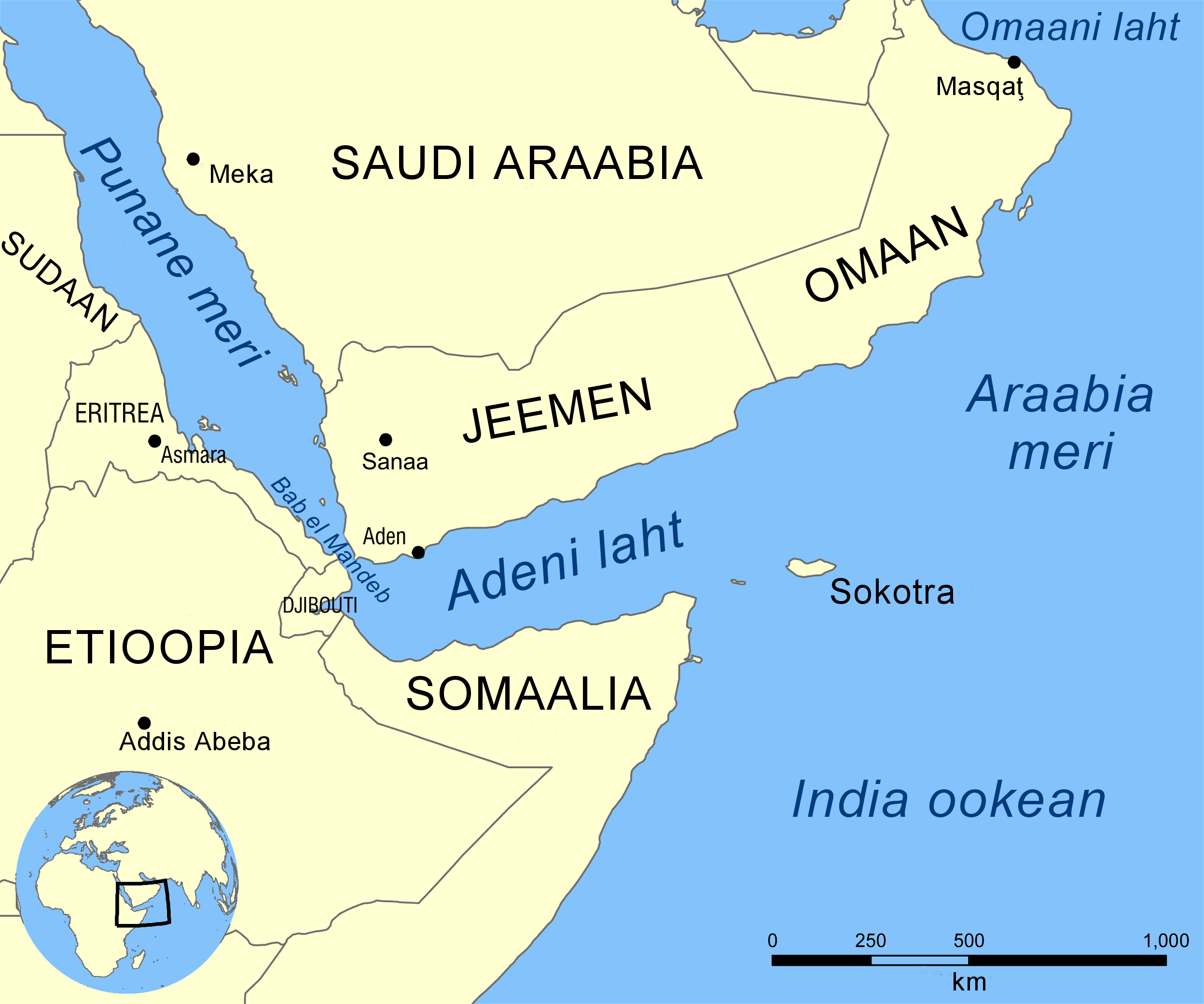
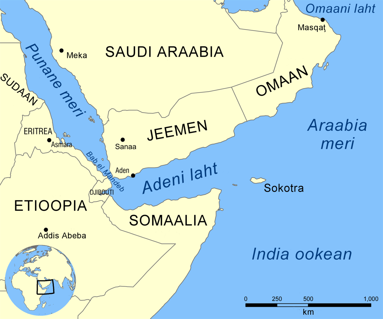
Eesti: Adeni lahe kaart English: Map showing the location of the Gulf of Aden, located between Yemen and Somalia. Nearby bodies of water include the Indian Ocean, Red Sea, Arabian Sea, and the Bab-el-Mandeb Strait. Español: Golfo de Adén, localizado en el Mar arábigo, entre Yemén y Somalia (o Somalilandia). Hrvatski: Adenski zaljev Қазақша: Аден шығанағының орналасуын көрсететін қазақтілді карта. Русский: Карта на казахском языке, показывающяя местоположение Аденского залива. العربية : خريطة تُبيِّن موقع خليج عدن بين اليمن والصومال. المُسطحات المائيَّة المُجاورة هي: المُحيط الهندي والبحر الأحمر وبحر العرب ومضيق باب المندب. |
||
| Date | |||
| Source |
This file was derived from: Gulf of Aden map.png |
||
| Author | NormanEinstein, Epp (translation) | ||
| Other versions |
[]
|


Licensing
[edit]
This file is licensed under the Creative Commons Attribution-Share Alike 3.0 Unported license.
- You are free:
- to share – to copy, distribute and transmit the work
- to remix – to adapt the work
- Under the following conditions:
- attribution – You must give appropriate credit, provide a link to the license, and indicate if changes were made. You may do so in any reasonable manner, but not in any way that suggests the licensor endorses you or your use.
- share alike – If you remix, transform, or build upon the material, you must distribute your contributions under the same or compatible license as the original.
Original upload log
[edit]
The original description page was here. All following user names refer to et.wikipedia.
| Date/Time | Dimensions | User | Comment |
|---|---|---|---|
| 10:53, 2 June 2010 | 2500 × 2086 (579101 B) | Epp | Tegin [http://en.wikipedia.org/wiki/File:Gulf_of_Aden_map.png selle] põhjal |
File history
Click on a date/time to view the file as it appeared at that time.
| Date/Time | Thumbnail | Dimensions | User | Comment | |
|---|---|---|---|---|---|
| current | 14:38, 16 January 2019 | | 2,495 × 2,081 (731 KB) | Pikne (talk | contribs) | Şan‘ā’ > Sanaa |
| 18:13, 19 November 2014 |  | 2,500 × 2,086 (566 KB) | Pikne (talk | contribs) | Transferred from et.wikipedia: see original upload log above |
You cannot overwrite this file.
File usage on Commons
The following 6 pages use this file:
File usage on other wikis
The following other wikis use this file:
- Usage on et.wikipedia.org
- Usage on www.wikidata.org