File:Addis Abbeba to Boma, Lake Rudolf and Baringo. East Africa Protectorate. (WOMAT-AFR-ABY-32-3).jpg
Jump to navigation
Jump to search

Size of this preview: 740 × 600 pixels. Other resolutions: 296 × 240 pixels | 592 × 480 pixels | 948 × 768 pixels | 1,264 × 1,024 pixels | 2,528 × 2,048 pixels | 6,911 × 5,600 pixels.
Original file (6,911 × 5,600 pixels, file size: 26.47 MB, MIME type: image/jpeg)
Captions
Captions
Add a one-line explanation of what this file represents
Summary
[edit]
; ;
| Title |
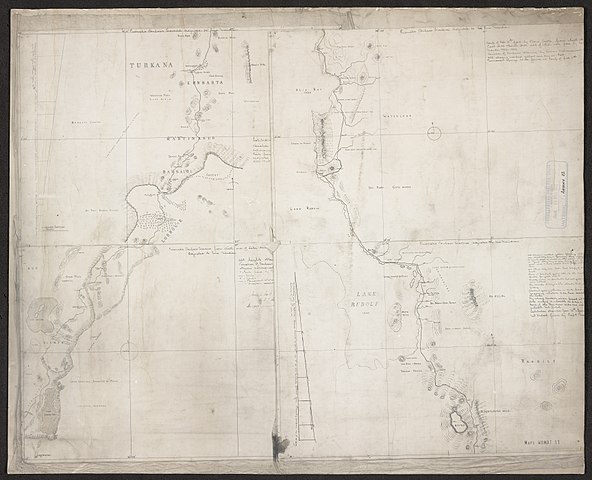
'Addis Abbeba to Boma, Lake Rudolf and Baringo. (E[ast]. A[frica]. P[rotectorate].)'. Created by Mr A. C. Hoey, 'Dec. 1909'. |
|||||||||
| Description |
Prismatic compass traverse from south of Baringo in western East Africa Protectorate 750 miles north-eastwards to Addis Abeba in central Abyssinia to a width of approximately 30 miles. Portrays hydrology, relief by form lines and spot heights, settlements, camps, place names and the expedition route, and includes topographical and ethnographical notes. The sheets also bear compilation notes, including reference to a previous survey by Captain P. Maud R.E.; a trimmed compilation note reads 'Made for Mr N.C. ... by A.C. Ho ... Dec. 1909'.The maps are unnumbered composite reproductions from nine originals, with notes revealing that at least two were in colour.The expedition route extends beyond the southern limit of these sheets, consistent with Hoey's (1911) account of it being 50 miles further south at Nakuru.The spelling 'Addis Abeba' is used on the map face; the variant 'Addis Abbeba' is used in the War Office ledger. 'Boma', as appears in the title, denotes an administrative centre and refers to 'Bako Boma'. |
|||||||||
| British Library Shelfmark | WOMAT/AFR/ABY/32/3 | |||||||||
| Locations Depicted | Addis Abeba, Abyssinia
Bako, Bako, Abyssinia Baringo, Naivasha, East Africa Protectorate East Africa Protectorate, East Africa, 1895-1920 Lake Rudolf, East Africa Protectorate / Abyssinia, before 1975 Nakuru, Naivashu, East Africa Protectorate |
|||||||||
| Centre Point Coordinates | 4.5455,37.5000 | |||||||||
| Date | ||||||||||
| Source |
|
|||||||||
| Creator |
Cockburn, Nathaniel Clayton, 1866-1924, army officer, Recipient Hoey, Arthur Cecil, 1883-1956, land manager, Surveyor Maud, Philip, 1870-1947, army officer and international rugby player, Surveyor |
|||||||||
| Permission (Reusing this file) |
|
|||||||||
| Geotemporal data | ||||||||||
| Map location | Abyssinia | |||||||||
| Scale | Scale 1:500,000 | |||||||||
| Bounding box |
|
|||||||||
| Georeferencing | If inappropriate please set warp_status = skip to hide. | |||||||||
| Archival data | ||||||||||
| Collection | ||||||||||
| Dimensions | 49 x 61cm or smaller | |||||||||
| Medium | Sun-print, with manuscript additions in ink | |||||||||
| Notes | For more information please see the British Library’s Collection Guide to the War Office Archive. | |||||||||

_(St_Edwards_Crown).svg)


.jpg&action=edit§ion=1)
.jpg¶ms=9.0909_N_36.0000_E_)
.jpg¶ms=9.0909_N_39.0000_E_)
.jpg¶ms=0.0000_N_36.0000_E_)
.jpg¶ms=0.0000_N_39.0000_E_)
File history
Click on a date/time to view the file as it appeared at that time.
| Date/Time | Thumbnail | Dimensions | User | Comment | |
|---|---|---|---|---|---|
| current | 20:09, 22 March 2018 | | 6,911 × 5,600 (26.47 MB) | Ndalyrose (talk | contribs) | GWToolset: Creating mediafile for Ndalyrose. |
You cannot overwrite this file.
File usage on Commons
There are no pages that use this file.
.jpg&oldid=781969306)