File:Achtal-Former Railway line-Rotachtunnel-Rotachbridge-101ESD.jpg
Jump to navigation
Jump to search

Size of this preview: 450 × 600 pixels. Other resolutions: 180 × 240 pixels | 360 × 480 pixels | 576 × 768 pixels | 768 × 1,024 pixels | 1,536 × 2,048 pixels | 3,456 × 4,608 pixels.
Original file (3,456 × 4,608 pixels, file size: 3.4 MB, MIME type: image/jpeg)
Captions
Captions
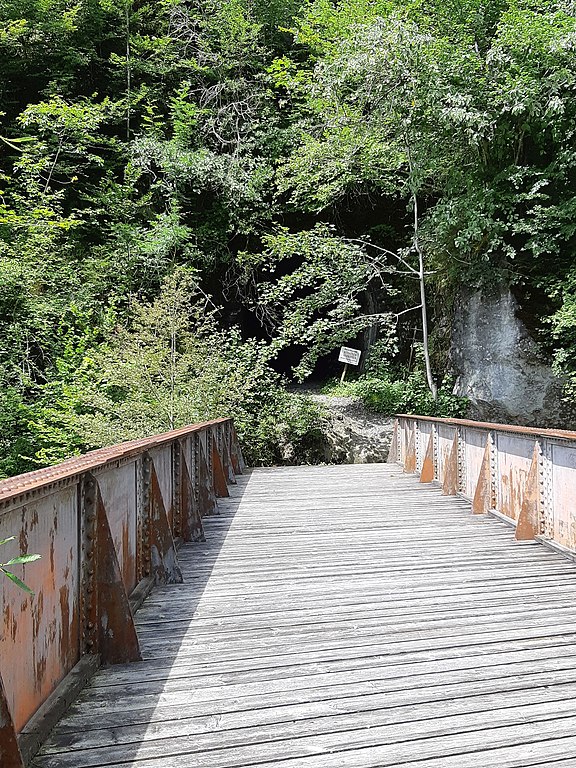
Disused Rotachbrücke near the Rotachtunnel - bridge of the former Bregenzerwaldbahn in Langen bei Bregenz/Doren (Vorarlberg, Austria)
Summary
[edit]
| Description |
Deutsch: Stillgelegte Rotachbrücke beim Rotachtunnel (ca. 453 m.ü.M.) der ehemaligen Bregenzerwaldbahn in der Gemeinde Langen bei Bregenz / de:Doren (Vorarlberg, Österreich) an der Bregenzer Ache. In der Mitte der Brücke verläuft die Grenze zwischen der Gemeinde Langen bei Bregenz und Doren. Unter der Brücke fließt die Rotach (Rothach), die kurz nach der Brücke in die Bregenzer Ache einmündet.
English: Disused Rotachbrücke near the Rotachtunnel (approx. 453 masl) of the former Bregenzerwaldbahn (Railway) in the municipality of Langen bei Bregenz (Vorarlberg, Austria) / Doren near the Bregenzer Ache (river). In the middle of the bridge runs the border between the municipality of Langen bei Bregenz and Doren. The Rotach (Rothach) flows under the bridge and flows into the Bregenzer Ache shortly after the bridge.
Français : Rotachbrücke désaffecté près du Rotachtunnel désaffectée (environ 453 mètres d'altitude) de l'ancienne Bregenzerwaldbahn (chemin de fer) dans la municipalité de Langen bei Bregenz / Doren (Vorarlberg, Autriche) dans le Bregenzer Ache (rivière). Au milieu du pont passe la frontière entre la commune de Langen bei Bregenz et Doren. Le Rotach (Rothach) coule sous le pont et se jette dans le Bregenzer Ache peu après le pont. |
| Date | |
| Source | Own work |
| Author | Rikki Mitterer |
| Camera location | | View this and other nearby images on: OpenStreetMap |
|---|
Licensing
[edit]
I, the copyright holder of this work, hereby publish it under the following license:
This file is licensed under the Creative Commons Attribution-Share Alike 4.0 International license.
- You are free:
- to share – to copy, distribute and transmit the work
- to remix – to adapt the work
- Under the following conditions:
- attribution – You must give appropriate credit, provide a link to the license, and indicate if changes were made. You may do so in any reasonable manner, but not in any way that suggests the licensor endorses you or your use.
- share alike – If you remix, transform, or build upon the material, you must distribute your contributions under the same or compatible license as the original.
File history
Click on a date/time to view the file as it appeared at that time.
| Date/Time | Thumbnail | Dimensions | User | Comment | |
|---|---|---|---|---|---|
| current | 21:25, 26 August 2020 | | 3,456 × 4,608 (3.4 MB) | Rikki Mitterer (talk | contribs) | Uploaded own work with UploadWizard |
You cannot overwrite this file.
File usage on Commons
The following 3 pages use this file: