File:Achaemenid empire map expansion.png
Jump to navigation
Jump to search
Size of this preview: 800 × 511 pixels. Other resolutions: 320 × 205 pixels | 640 × 409 pixels | 1,020 × 652 pixels.
Original file (1,020 × 652 pixels, file size: 34 KB, MIME type: image/png)
Captions
Captions
Add a one-line explanation of what this file represents
Summary
[edit]
| Description |
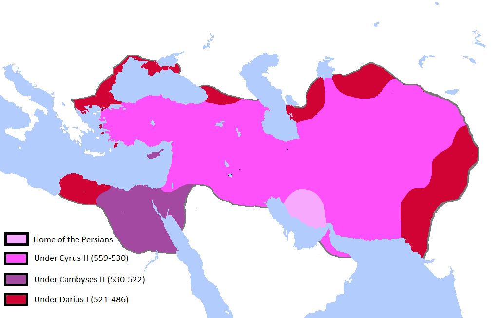
English: Updated the map by delineating the conquests of the three major Persian conqueror Kings, and also adding the names of the main satrapies of the empire. As a source I used this map of Ian Mladjov's Resources from the University of Michigan's History department. Link:http://sitemaker.umich.edu/mladjov/home |
| Date | |
| Source | On Microsoft Paint |
| Author | Javierfv1212 |
Licensing
[edit]
I, the copyright holder of this work, hereby publish it under the following licenses:

|
Permission is granted to copy, distribute and/or modify this document under the terms of the GNU Free Documentation License, Version 1.2 or any later version published by the Free Software Foundation; with no Invariant Sections, no Front-Cover Texts, and no Back-Cover Texts. A copy of the license is included in the section entitled GNU Free Documentation License. |
This file is licensed under the Creative Commons Attribution-Share Alike 3.0 Unported license.
- You are free:
- to share – to copy, distribute and transmit the work
- to remix – to adapt the work
- Under the following conditions:
- attribution – You must give appropriate credit, provide a link to the license, and indicate if changes were made. You may do so in any reasonable manner, but not in any way that suggests the licensor endorses you or your use.
- share alike – If you remix, transform, or build upon the material, you must distribute your contributions under the same or compatible license as the original.
You may select the license of your choice.
File history
Click on a date/time to view the file as it appeared at that time.
| Date/Time | Thumbnail | Dimensions | User | Comment | |
|---|---|---|---|---|---|
| current | 00:41, 14 October 2015 | | 1,020 × 652 (34 KB) | LouisAragon (talk | contribs) | Reverted mostly hoax edits (except Macedon) by user:HistoryofPersia |
| 23:40, 11 October 2015 |  | 1,012 × 648 (34 KB) | History of Persia (talk | contribs) | macedonia | |
| 17:29, 3 August 2015 |  | 1,012 × 648 (32 KB) | History of Persia (talk | contribs) | There is no account saying cambyses conquered cyprus (the island), so it is more likely that it was conquered by cyrus, and became part of the babylonian province (which became the eber-nari province | |
| 16:51, 3 August 2015 |  | 1,012 × 648 (32 KB) | History of Persia (talk | contribs) | Cambyses did not subdue the arabs in his egyptian campaign. achaemenid arabia only appears in an inscription from the reign of darius. But it is possible that (along with eber nari), arabia was originally part of the babylonian province but later split... | |
| 00:08, 2 August 2015 |  | 1,012 × 648 (32 KB) | History of Persia (talk | contribs) | Gandhara empires borders where more like this version of the file. evidence: http://www.worldhistorymaps.info/images/East-Hem_600bc.jpg & https://en.wikipedia.org/wiki/Gandhara_Kingdom#/media/File:Gandhara.JPG. no one noticed until now i guess | |
| 23:45, 1 August 2015 |  | 1,020 × 652 (34 KB) | History of Persia (talk | contribs) | Added territories of the gandhara kingdom and a more likely border of gedrosia | |
| 16:13, 27 July 2015 |  | 1,020 × 652 (34 KB) | History of Persia (talk | contribs) | Cyrus created cyropolis | |
| 06:59, 16 July 2015 |  | 1,020 × 652 (34 KB) | History of Persia (talk | contribs) | if readers want to see the provinces/satrapies they can see another map. For the map of the empire we dont need the inclusion of satrapies. | |
| 23:42, 26 February 2015 |  | 1,020 × 652 (59 KB) | Javierfv1212 (talk | contribs) | {{subst:Upload marker added by en.wp UW}} {{Information |Description = {{en|Updated the map by delineating the conquests of the three major Persian conqueror Kings, and also adding the names of the main satrapies of the empire. As a source I used this... |
You cannot overwrite this file.
File usage on Commons
There are no pages that use this file.
File usage on other wikis
The following other wikis use this file:
- Usage on ar.wikipedia.org
- Usage on en.wikipedia.org
- Usage on hy.wikipedia.org
- Usage on hyw.wikipedia.org
- Usage on ku.wikipedia.org
- Usage on pt.wikipedia.org
- Usage on tr.wikipedia.org