File:Abra'l Pas.jpg
Jump to navigation
Jump to search

Size of this preview: 496 × 599 pixels. Other resolutions: 199 × 240 pixels | 397 × 480 pixels | 635 × 768 pixels | 847 × 1,024 pixels | 2,304 × 2,784 pixels.
Original file (2,304 × 2,784 pixels, file size: 548 KB, MIME type: image/jpeg)
Captions
Captions
Add a one-line explanation of what this file represents
Summary
[edit]
| Description |
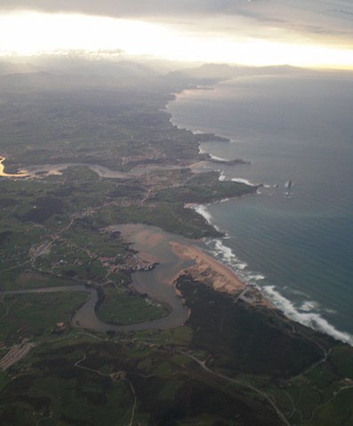
Español: En primer plano abra del Pas o ría de Mogro, desembocadura del río Pas en el mar Cantábrico entre los municipios cántabros de Piélagos y Miengo, y playa de Valdearenas. Detrás desembocadura del río Saja-Besaya en la ría de San Martín de la Arena, entre Miengo y Suances.
Montañés: En primer planu abra'l Pas o la ría Mogru, desembocaura'l ríu Pas nel mar Cantábricu enti los concejos cántabros de Piélagos y Miengu, y sable de Valdearenas. Tres d'ellu desembocaura'l ríu Saḥa-Besaya ena ría Samartín, enti Miengu y Suancis. |
| Date | |
| Source | Own work/Trebaju sellencu |
| Author | Uhanu |
| Camera location | | View this and other nearby images on: OpenStreetMap |
|---|
Licensing
[edit]
I, the copyright holder of this work, hereby publish it under the following licenses:

|
Permission is granted to copy, distribute and/or modify this document under the terms of the GNU Free Documentation License, Version 1.2 or any later version published by the Free Software Foundation; with no Invariant Sections, no Front-Cover Texts, and no Back-Cover Texts. A copy of the license is included in the section entitled GNU Free Documentation License. |
This file is licensed under the Creative Commons Attribution-Share Alike Attribution-Share Alike 4.0 International, 3.0 Unported, 2.5 Generic, 2.0 Generic and 1.0 Generic license.
- You are free:
- to share – to copy, distribute and transmit the work
- to remix – to adapt the work
- Under the following conditions:
- attribution – You must give appropriate credit, provide a link to the license, and indicate if changes were made. You may do so in any reasonable manner, but not in any way that suggests the licensor endorses you or your use.
- share alike – If you remix, transform, or build upon the material, you must distribute your contributions under the same or compatible license as the original.
You may select the license of your choice.
| Annotations | This image is annotated: View the annotations at Commons |
File history
Click on a date/time to view the file as it appeared at that time.
| Date/Time | Thumbnail | Dimensions | User | Comment | |
|---|---|---|---|---|---|
| current | 22:04, 23 April 2010 | | 2,304 × 2,784 (548 KB) | Uhanu (talk | contribs) | {{Information |Description={{es|1=En primer plano abra del Pas o ría de Mogro, desembocadura del río Pas en el mar Cantábrico entre los municipios cántabros de Piélagos y Miengo, y playa de Valdearenas. Detrás desembocadura del río Saja-Besaya en l |
You cannot overwrite this file.
File usage on Commons
The following page uses this file:
File usage on other wikis
The following other wikis use this file:
- Usage on eo.wikipedia.org
- Usage on es.wikipedia.org
- Usage on gl.wikipedia.org
- Usage on www.wikidata.org