File:Aberystwyth station, with a Manor 4-6-0 on train for Whitchurch, 1952 (geograph 5043029).jpg
Jump to navigation
Jump to search
Size of this preview: 800 × 441 pixels. Other resolutions: 320 × 177 pixels | 640 × 353 pixels | 1,024 × 565 pixels | 1,280 × 706 pixels | 2,346 × 1,294 pixels.
Original file (2,346 × 1,294 pixels, file size: 1.26 MB, MIME type: image/jpeg)
Captions
Captions
Add a one-line explanation of what this file represents
Summary
[edit].jpg&action=edit§ion=1)
| Description |
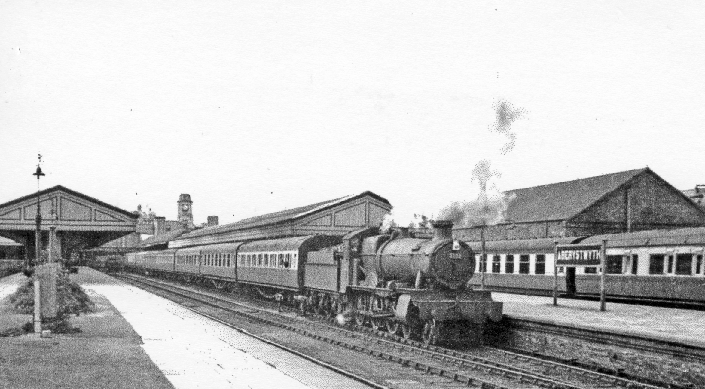
English: Aberystwyth station, with a 'Manor' 4-6-0 on train for Whitchurch, 1952 View towards the buffers of this ex-Cambrian Railway and ex-GWR terminus of lines from Whitchurch via Oswestry and Welshpool, and Pwllheli, and Machynlleth, also from Carmarthen. The 18.00 to Whitchurch is headed by Collett 'Manor' class 4-6-0 No. 7808 'Cookham Manor' (built 3/38, withdrawn 12/65 and preserved - at Didcot Railway Centre). |
| Date | |
| Source | From geograph.org.uk |
| Author | Walter Dendy, deceased |
| Permission (Reusing this file) |
Creative Commons Attribution Share-alike license 2.0 |
| Attribution (required by the license) | Walter Dendy, deceased / Aberystwyth station, with a 'Manor' 4-6-0 on train for Whitchurch, 1952 / |
| Camera location | | View this and other nearby images on: OpenStreetMap |
|---|
.jpg¶ms=052.413340_N_-004.080978_E_globe:Earth_type:camera_heading:315.00_source:geograph&language=en)
| Object location | | View this and other nearby images on: OpenStreetMap |
|---|
.jpg¶ms=052.413390_N_-004.080900_E_globe:Earth_class:object_type:object_source:geograph-osgb36(SN58568152)_region:GB-GBN_heading:315.00&language=en)
Licensing
[edit].jpg&action=edit§ion=2)

|
This image was taken from the Geograph project collection. See this photograph's page on the Geograph website for the photographer's contact details. The copyright on this image is owned by Walter Dendy, deceased and is licensed for reuse under the Creative Commons Attribution-ShareAlike 2.0 license.
|
This file is licensed under the Creative Commons Attribution-Share Alike 2.0 Generic license.
Attribution: Walter Dendy, deceased
- You are free:
- to share – to copy, distribute and transmit the work
- to remix – to adapt the work
- Under the following conditions:
- attribution – You must give appropriate credit, provide a link to the license, and indicate if changes were made. You may do so in any reasonable manner, but not in any way that suggests the licensor endorses you or your use.
- share alike – If you remix, transform, or build upon the material, you must distribute your contributions under the same or compatible license as the original.
File history
Click on a date/time to view the file as it appeared at that time.
| Date/Time | Thumbnail | Dimensions | User | Comment | |
|---|---|---|---|---|---|
| current | 14:21, 29 July 2017 | | 2,346 × 1,294 (1.26 MB) | Das48 (talk | contribs) | Transferred from geograph.co.uk using [https://tools.wmflabs.org/geograph2commons/ geograph2commons] |
You cannot overwrite this file.
File usage on Commons
There are no pages that use this file.
File usage on other wikis
The following other wikis use this file:
- Usage on en.wikipedia.org
- Usage on sco.wikipedia.org
.jpg&oldid=779861149)