File:A topographical map of the Northern part of New York Island, exhibiting the plan of Fort Washington, now Fort Knyphasen, showing the several attacks on the Royal Army - DPLA - 9fd0facb681fc214143eeb4ddd84a386.jpg
Jump to navigation
Jump to search

Size of this preview: 349 × 599 pixels. Other resolutions: 140 × 240 pixels | 279 × 480 pixels | 447 × 768 pixels | 596 × 1,024 pixels | 1,193 × 2,048 pixels | 3,435 × 5,896 pixels.
Original file (3,435 × 5,896 pixels, file size: 3.02 MB, MIME type: image/jpeg)
Captions
Captions
Add a one-line explanation of what this file represents
Summary
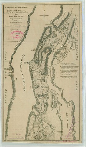
[edit]| A topographical map of the Northern part of New York Island, exhibiting the plan of Fort Washington, now Fort Knyphasen, showing the several attacks on the Royal Army
( |
||||||||||||||
|---|---|---|---|---|---|---|---|---|---|---|---|---|---|---|
| Creator | War Department. Office of the Chief of Engineers. War Department Map Collection. 1939-1942 | |||||||||||||
| Title |
A topographical map of the Northern part of New York Island, exhibiting the plan of Fort Washington, now Fort Knyphasen, showing the several attacks on the Royal Army |
|||||||||||||
| Description |
Engraved for Stedmans History of the American War |
|||||||||||||
| Date | 1939-01-01/1942-12-31 | |||||||||||||
| Collection |
|
|||||||||||||
| Source/Photographer |
|
|||||||||||||
| Permission (Reusing this file) |
|
|||||||||||||
| Standardized rights statement |
|
|||||||||||||


File history
Click on a date/time to view the file as it appeared at that time.
| Date/Time | Thumbnail | Dimensions | User | Comment | |
|---|---|---|---|---|---|
| current | 17:44, 10 November 2022 | | 3,435 × 5,896 (3.02 MB) | DPLA bot (talk | contribs) | Uploading DPLA ID 9fd0facb681fc214143eeb4ddd84a386 |
You cannot overwrite this file.
File usage on Commons
The following page uses this file: