File:A sketch of the roads within fourteen miles of Tunbridge Wells. LOC 2018588064.jpg
Jump to navigation
Jump to search

Size of this preview: 580 × 599 pixels. Other resolutions: 232 × 240 pixels | 464 × 480 pixels | 743 × 768 pixels | 991 × 1,024 pixels | 1,982 × 2,048 pixels | 5,218 × 5,393 pixels.
Original file (5,218 × 5,393 pixels, file size: 4.46 MB, MIME type: image/jpeg)
Captions
Captions
Add a one-line explanation of what this file represents
Summary
[edit]| Description |
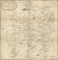
English: Regional road map showing populated places and wooded areas. Relief shown by landform drawing and pictorially. The scripted signature of Millard Fillmore is not present on recto or verso. Available also through the Library of Congress Web site as a raster image. LC sheet imperfect: Use-worn, LC accession rubber-stamping in map-content area (lower right), lead-pencil annotations on cloth backing (verso). Includes embellished (vine imagery) title cartouche. Handwritten number slip "243" affixed to cloth backing; handwritten (ink script) map identification statement on cloth backing (verso): 32 Tunbridge Wells 1802. Vault |
||
| Title | A sketch of the roads within fourteen miles of Tunbridge Wells. | ||
| Shelf ID | G5754.T8P2 1802 .S6 | ||
| Date | |||
| Source | https://www.loc.gov/item/2018588064/ | ||
| Author | Sprange, J. (Jasper); Fillmore, Millard | ||
| Permission (Reusing this file) |
|
||
| Other versions |
|
||
| Location | Tunbridge Wells Region · England | ||
| Part of | American Memory · General Maps · Geography And Map Division | ||
| Subject | Tunbridge Wells Region (England) · England · Maps · Tunbridge Wells Region · Roads · Road Maps |

Licensing
[edit]
|
This is a faithful photographic reproduction of a two-dimensional, public domain work of art. The work of art itself is in the public domain for the following reason:
The official position taken by the Wikimedia Foundation is that "faithful reproductions of two-dimensional public domain works of art are public domain".
This photographic reproduction is therefore also considered to be in the public domain in the United States. In other jurisdictions, re-use of this content may be restricted; see Reuse of PD-Art photographs for details. | ||||
File history
Click on a date/time to view the file as it appeared at that time.
| Date/Time | Thumbnail | Dimensions | User | Comment | |
|---|---|---|---|---|---|
| current | 22:21, 30 July 2018 | | 5,218 × 5,393 (4.46 MB) | Fæ (talk | contribs) | LOC Maps https://www.loc.gov/item/2018588064/ #16273 |
You cannot overwrite this file.
File usage on Commons
The following page uses this file: