File:A new map of Ireland civil and ecclesiastical by the Rev.d D. A. Beaufort LLD Member of the Royal Irish Academy. 2nd Edn 1797 RMG K0912.jpg
Jump to navigation
Jump to search

Size of this preview: 800 × 509 pixels. Other resolutions: 320 × 204 pixels | 640 × 408 pixels | 1,024 × 652 pixels | 1,280 × 815 pixels.
Original file (1,280 × 815 pixels, file size: 1,009 KB, MIME type: image/jpeg)
Captions
Captions
Add a one-line explanation of what this file represents
Summary
[edit]
| Author |
Neale; Reverend Daniel Augustus Beaufort |
| Description |
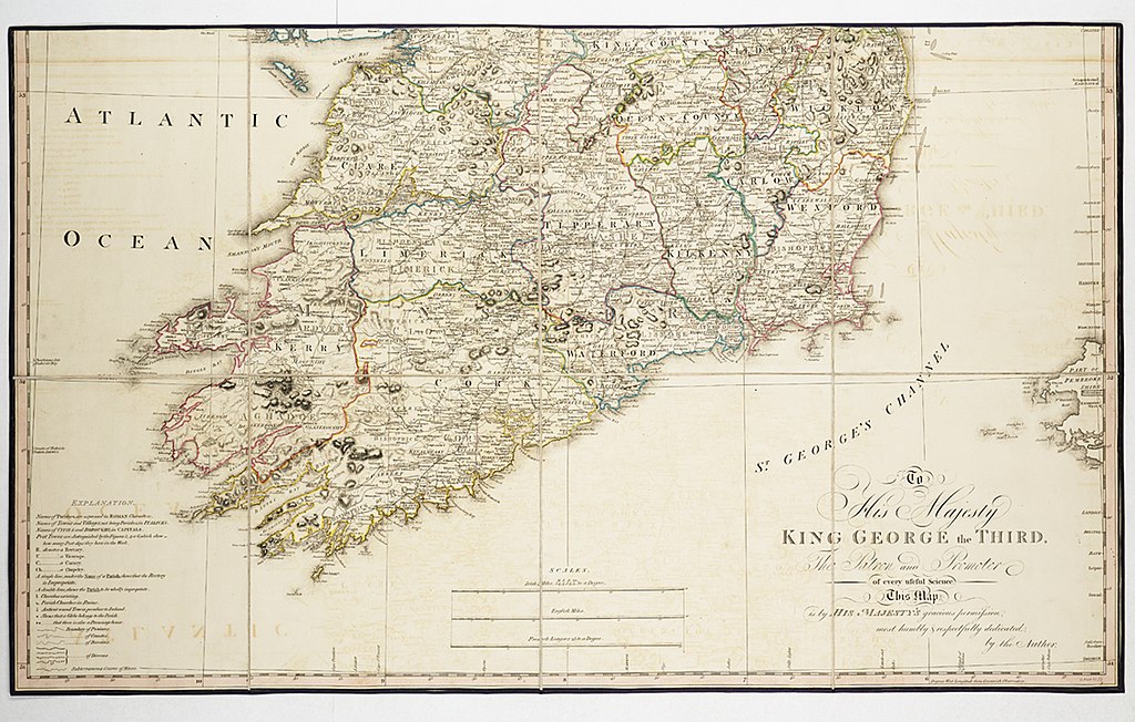
English: A new map of Ireland civil and ecclesiastical by the Rev.d D. A. Beaufort LLD Member of the Royal Irish Academy. 2nd Edn 1797Two sheets. Engr. Medium: Segmented and backed. Physical description Note: Coloured in outline. Scale: 1:500 000 (bar). Cartographic Note: Globular projection, meridian of Greenwich. Scales in Irish miles, English miles and French leagues. Contents Note: Dedicated to King George III. The cartouche shows cherubs with Irish produce and a cameo of George III on a quayside as a Royal Naval ship sails past. Ashore there is a church with its tower in scaffolding and a more distant Irish round tower against a backdrop of mountains, Contains a key to post towns, rectories, states of parishes and churches, Contains an advertisement for 'A memoir, illustrative of this map, with a complete index... and an account of the present state of Ireland'. Gren2C/3(2) A new map of Ireland civil and ecclesiastical by the Rev.d D. A. Beaufort LLD Member of the Royal Irish Academy. 2nd Edn 1797 |
| Date | 1797; 1792 |
| Dimensions | Each sheet 53.5 x 88.5cm. |
| Source/Photographer | http://collections.rmg.co.uk/collections/objects/542083 |
| Permission (Reusing this file) |
The original artefact or artwork has been assessed as public domain by age, and faithful reproductions of the two dimensional work are also public domain. No permission is required for reuse for any purpose. The text of this image record has been derived from the Royal Museums Greenwich catalogue and image metadata. Individual data and facts such as date, author and title are not copyrightable, but reuse of longer descriptive text from the catalogue may not be considered fair use. Reuse of the text must be attributed to the "National Maritime Museum, Greenwich, London" and a Creative Commons CC-BY-NC-SA-3.0 license may apply if not rewritten. Refer to Royal Museums Greenwich copyright. |
| Identifier | id number: GREN2C/3 |
| Collection | Charts and maps |
Licensing
[edit]
|
This is a faithful photographic reproduction of a two-dimensional, public domain work of art. The work of art itself is in the public domain for the following reason:
The official position taken by the Wikimedia Foundation is that "faithful reproductions of two-dimensional public domain works of art are public domain".
This photographic reproduction is therefore also considered to be in the public domain in the United States. In other jurisdictions, re-use of this content may be restricted; see Reuse of PD-Art photographs for details. | ||||
File history
Click on a date/time to view the file as it appeared at that time.
| Date/Time | Thumbnail | Dimensions | User | Comment | |
|---|---|---|---|---|---|
| current | 07:35, 14 August 2017 | | 1,280 × 815 (1,009 KB) | Fæ (talk | contribs) | Royal Museums Greenwich Charts and maps, http://collections.rmg.co.uk/collections/objects/542083 |
You cannot overwrite this file.
File usage on Commons
The following page uses this file: