File:A new and accurate map of the British dominions in America, according to the Treaty of 1763, divided into the several provinces and jurisdictions - projected upon the best authorities and astronomical LOC 86695760.jpg
Jump to navigation
Jump to search

Size of this preview: 741 × 599 pixels. Other resolutions: 297 × 240 pixels | 594 × 480 pixels | 950 × 768 pixels | 1,266 × 1,024 pixels | 2,533 × 2,048 pixels | 8,304 × 6,715 pixels.
Original file (8,304 × 6,715 pixels, file size: 9.28 MB, MIME type: image/jpeg)
Captions
Captions
Add a one-line explanation of what this file represents
Summary
[edit]| Description |
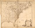
English: Relief shown pictorially. From label pasted on: Engraved for Captn. Knox's History of the war in America. (1769). Available also through the Library of Congress Web site as a raster image. LC Maps of North America, 1750-1789 124. Vault |
||
| Title | A new and accurate map of the British dominions in America, according to the Treaty of 1763, divided into the several provinces and jurisdictions : projected upon the best authorities and astronomical observations | ||
| Shelf ID | G3300 1763 .K52 | ||
| Date | |||
| Source | https://www.loc.gov/item/86695760/ | ||
| Author | Kitchin, Thomas | ||
| Permission (Reusing this file) |
|
||
| Other versions |
|
||
| Location | North America | ||
| Part of | Military Battles And Campaigns · American Memory · Catalog · Geography And Map Division · American Revolution And Its Era: Maps And Charts Of North America And The West Indies, 1750-1789 | ||
| Subject | North America · Maps · Early Works To 1800 · British |

Licensing
[edit]
|
This is a faithful photographic reproduction of a two-dimensional, public domain work of art. The work of art itself is in the public domain for the following reason:
The official position taken by the Wikimedia Foundation is that "faithful reproductions of two-dimensional public domain works of art are public domain".
This photographic reproduction is therefore also considered to be in the public domain in the United States. In other jurisdictions, re-use of this content may be restricted; see Reuse of PD-Art photographs for details. | ||||
File history
Click on a date/time to view the file as it appeared at that time.
| Date/Time | Thumbnail | Dimensions | User | Comment | |
|---|---|---|---|---|---|
| current | 04:12, 15 May 2018 | | 8,304 × 6,715 (9.28 MB) | Fæ (talk | contribs) | LOC Maps https://www.loc.gov/item/86695760/ #289 |
You cannot overwrite this file.
File usage on Commons
The following page uses this file: