File:A new & accurate map of Negroland and the adjacent countries - also upper Guinea, showing the principle European settlements & distinguishing wch. belong to England, Denmark, Holland & c - the sea of LOC 2018585377.jpg
Jump to navigation
Jump to search

Size of this preview: 725 × 599 pixels. Other resolutions: 290 × 240 pixels | 581 × 480 pixels | 929 × 768 pixels | 1,239 × 1,024 pixels | 2,477 × 2,048 pixels | 5,698 × 4,711 pixels.
Original file (5,698 × 4,711 pixels, file size: 4.23 MB, MIME type: image/jpeg)
Captions
Captions
Add a one-line explanation of what this file represents
Summary
[edit]| Description |
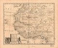
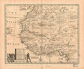
English: Relief shown pictorially. Decorative title cartouche with figures. Shows boundaries, rivers and principle settlements, with tents showing areas inhabited by nomads. Includes notes. Copy imperfect: Mounted on paper backing, stained along center fold line and throughout. Handwritten at bottom: A complete system of Geog. Emanuel Bowen London 1747. Available also through the Library of Congress Web site as a raster image. |
||
| Title | A new & accurate map of Negroland and the adjacent countries : also upper Guinea, showing the principle European settlements & distinguishing wch. belong to England, Denmark, Holland & c : the sea of the rivers being drawn from surveys & the best modern maps and charts, & regulated by astron. observns | ||
| Shelf ID | G8735 1747 .B6 G8735 1747 .B6 Copy 2 | ||
| Date | |||
| Source | https://www.loc.gov/item/2018585377/ | ||
| Author | Bowen, Emanuel | ||
| Permission (Reusing this file) |
|
||
| Other versions |
|
||
| Location | Northwest Africa · Africa, West. · Africa, West · Africa, Northwest · West Africa · Africa, Northwest. | ||
| Part of | American Memory · Catalog · Geography And Map Division · Cultural Landscapes | ||
| Subject | Early Maps · Maps · Early Works To 1800 · Africa, Northwest · Africa, West |

Licensing
[edit]
|
This is a faithful photographic reproduction of a two-dimensional, public domain work of art. The work of art itself is in the public domain for the following reason:
The official position taken by the Wikimedia Foundation is that "faithful reproductions of two-dimensional public domain works of art are public domain".
This photographic reproduction is therefore also considered to be in the public domain in the United States. In other jurisdictions, re-use of this content may be restricted; see Reuse of PD-Art photographs for details. | ||||
File history
Click on a date/time to view the file as it appeared at that time.
| Date/Time | Thumbnail | Dimensions | User | Comment | |
|---|---|---|---|---|---|
| current | 14:41, 30 November 2018 | | 5,698 × 4,711 (4.23 MB) | Fæ (talk | contribs) | LOC Maps https://www.loc.gov/item/2018585377/ #5481 |
You cannot overwrite this file.
File usage on Commons
The following page uses this file: