File:A neighborhood sits under water after Hurricane Isaac in Louisiana Aug. 11, 2012 120811-G-ZZ999-002.jpg
Original file (3,792 × 2,528 pixels, file size: 1.09 MB, MIME type: image/jpeg)
Captions
Camera location | 30° 04′ 35.37″ N, 90° 28′ 04.32″ W | View this and other nearby images on: OpenStreetMap | 30.076493; -90.467867 |
---|
Summary
[edit]DescriptionA neighborhood sits under water after Hurricane Isaac in Louisiana Aug. 11, 2012 120811-G-ZZ999-002.jpg |
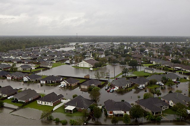
English: A neighborhood sits under water after Hurricane Isaac in Louisiana Aug. 11, 2012.
Church seen at center of photo is The Church of Jesus Christ of Latter-day Saints, 15 Palmetto Dr, Laplace, Louisiana. |
|||
Date | Taken on 11 August 2012 | |||
Source | http://www.defenseimagery.mil/imageRetrieve.action?guid=89b530cc6457cf46fbb88a7dcf601aa03fc95685&t=2 | |||
Author | Unknown authorUnknown author | |||
Permission (Reusing this file) |
Public domain photograph from defenseimagery.mil. | |||
Location InfoField | Unknown locationUnknown location | |||
VIRIN InfoField |
|
|||
Gallery page InfoField | http://www.defenseimagery.mil/imagery.html?&guid=89b530cc6457cf46fbb88a7dcf601aa03fc95685 | |||
Posted InfoField | 8 January 2013 |
Licensing
[edit]Public domainPublic domainfalsefalse |
This image is a work of a U.S. military or Department of Defense employee, taken or made as part of that person's official duties. As a work of the U.S. federal government, the image is in the public domain in the United States.
العربية ∙ català ∙ čeština ∙ Deutsch ∙ Ελληνικά ∙ English ∙ español ∙ eesti ∙ فارسی ∙ suomi ∙ français ∙ galego ∙ हिन्दी ∙ hrvatski ∙ magyar ∙ italiano ∙ 日本語 ∙ 한국어 ∙ македонски ∙ മലയാളം ∙ Malti ∙ Nederlands ∙ polski ∙ português ∙ português do Brasil ∙ română ∙ русский ∙ sicilianu ∙ slovenčina ∙ slovenščina ∙ српски / srpski ∙ ไทย ∙ Türkçe ∙ українська ∙ Tiếng Việt ∙ 中文 ∙ 中文(简体) ∙ 中文(繁體) ∙ +/− |
File history
Click on a date/time to view the file as it appeared at that time.
Date/Time | Thumbnail | Dimensions | User | Comment | |
---|---|---|---|---|---|
current | 18:45, 9 August 2013 | 3,792 × 2,528 (1.09 MB) | Fæ (talk | contribs) | == {{int:filedesc}} == {{milim | description = {{en|A neighborhood sits under water after Hurricane Isaac in Louisiana Aug. 11, 2012.}} | date = 2012-08-11 | author = Unknown | source = http://www.defenseimagery.mil/imageRetrieve.action?guid=89b530cc64... |
You cannot overwrite this file.
File usage on Commons
There are no pages that use this file.
Metadata
This file contains additional information such as Exif metadata which may have been added by the digital camera, scanner, or software program used to create or digitize it. If the file has been modified from its original state, some details such as the timestamp may not fully reflect those of the original file. The timestamp is only as accurate as the clock in the camera, and it may be completely wrong.
Image title |
|
---|---|
Camera manufacturer | PENTAX |
Camera model | PENTAX Optio WG-2 GPS |
Exposure time | 1/160 sec (0.00625) |
F-number | f/4.2 |
ISO speed rating | 125 |
Date and time of data generation | 13:39, 30 August 2011 |
Lens focal length | 5 mm |
Latitude | 30° 4′ 35.38″ N |
Longitude | 90° 28′ 4.32″ W |
Altitude | 260.5 meters above sea level |
Author | U.S. Coast Guard District 8 PADET Houston, Unknown |
Short title |
|
Copyright holder | Public Domain |
City shown | Houston |
Headline | Coast Guard responds during Hurricane Isaac |
Credit/Provider | U.S. Coast Guard |
Source | digital |
Width | 3,792 px |
Height | 2,528 px |
Bits per component |
|
Pixel composition | RGB |
Orientation | Normal |
Number of components | 3 |
Horizontal resolution | 240 dpi |
Vertical resolution | 240 dpi |
Software used | Adobe Photoshop CS5.1 Macintosh |
File change date and time | 00:00, 11 August 2012 |
Exif version | 2.3 |
Date and time of digitizing | 00:00, 11 August 2012 |
APEX shutter speed | 7.321928 |
APEX aperture | 4.140779 |
APEX exposure bias | 0 |
Metering mode | Pattern |
Flash | Flash did not fire, auto mode |
Color space | Uncalibrated |
Custom image processing | Normal process |
Exposure mode | Auto exposure |
White balance | Auto white balance |
Digital zoom ratio | 1 |
Focal length in 35 mm film | 28 mm |
Scene capture type | Standard |
Contrast | Normal |
Saturation | Normal |
Sharpness | Normal |
Subject distance range | Distant view |
GPS time (atomic clock) | 13:37 |
Satellites used for measurement | 00 |
Receiver status | Measurement interoperability |
Measurement mode | 3-dimensional measurement |
Geodetic survey data used | WGS-84 |
GPS date | 30 August 2012 |
GPS tag version | 0.0.3.2 |
Keywords |
|
Writer | IMD09 |
Special instructions | Released.Stephen Lehmann.U.S. Coast Guard District 8 PADET Houston.Stephen.b.lehmann@uscg.mil.via DVIDS |
Date metadata was last modified | 08:03, 16 November 2012 |
Rating (out of 5) | 2 |
Unique ID of original document | xmp.did:0280117407206811AE56F87ECF141BB4 |
Copyright status | Copyright status not set |
Country shown | United States of America |
Province or state shown | Louisiana |
Code for country shown | US |
IIM version | 4 |
Category | O - Other |
Supplemental categories | Unclassified |
Original transmission location code | USNORTHCOM |