File:A map of the State of New York - compiled from the latest authorities - including the turnpike roads now granted, as also the principal common roads connected therewith - intended as well for the LOC 2014585742.jpg
Jump to navigation
Jump to search

Size of this preview: 727 × 600 pixels. Other resolutions: 291 × 240 pixels | 582 × 480 pixels | 931 × 768 pixels | 1,242 × 1,024 pixels | 2,484 × 2,048 pixels | 6,216 × 5,126 pixels.
Original file (6,216 × 5,126 pixels, file size: 4.82 MB, MIME type: image/jpeg)
Captions
Captions
Add a one-line explanation of what this file represents
Summary
[edit]| Description |
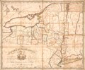
English: Shows turnpike roads, common roads, and counties. Relief shown pictorially. Hand colored to emphasize county boundaries. Prime meridian: The Battery (New York City). LC copy imperfect: Foxed, darkened, mounted on cloth backing, annotated in lead-pencil on cloth backing by forner owner "C. Eliot--Boston Ms." Includes state coat-of-arms in title cartouche. Available also through the Library of Congress Web site as a raster image. |
||
| Title | A map of the State of New York : compiled from the latest authorities : including the turnpike roads now granted, as also the principal common roads connected therewith : intended as well for the student in geography as a directory to the traveller | ||
| Shelf ID | G3801.P2 1808 .M3 | ||
| Date | |||
| Source | https://www.loc.gov/item/2014585742/ | ||
| Author | Mccalpin, Wm. (William) | ||
| Permission (Reusing this file) |
|
||
| Other versions |
|
||
| Location | United States · New York · New York (State) | ||
| Part of | American Memory · Catalog · Transportation And Communication · Geography And Map Division | ||
| Subject | United States · Toll Roads · Maps · Roads · New York (State) · Road Maps |

Licensing
[edit]
|
This is a faithful photographic reproduction of a two-dimensional, public domain work of art. The work of art itself is in the public domain for the following reason:
The official position taken by the Wikimedia Foundation is that "faithful reproductions of two-dimensional public domain works of art are public domain".
This photographic reproduction is therefore also considered to be in the public domain in the United States. In other jurisdictions, re-use of this content may be restricted; see Reuse of PD-Art photographs for details. | ||||
File history
Click on a date/time to view the file as it appeared at that time.
| Date/Time | Thumbnail | Dimensions | User | Comment | |
|---|---|---|---|---|---|
| current | 23:06, 9 May 2018 | | 6,216 × 5,126 (4.82 MB) | Fæ (talk | contribs) | LOC Maps https://www.loc.gov/item/2014585742/ #145 |
You cannot overwrite this file.
File usage on Commons
The following page uses this file: