File:A map of a portion of the Indian country lying east and west of the Mississippi River to the forty sixth degree of north latitude from personal observation made in the autumn of 1835 and recent LOC 96683128.jpg
Jump to navigation
Jump to search

Size of this preview: 800 × 558 pixels. Other resolutions: 320 × 223 pixels | 640 × 446 pixels | 1,024 × 714 pixels | 1,280 × 892 pixels | 2,560 × 1,785 pixels | 15,397 × 10,733 pixels.
Original file (15,397 × 10,733 pixels, file size: 14.9 MB, MIME type: image/jpeg)
Captions
Captions
Add a one-line explanation of what this file represents
Summary
[edit]| Warning | The original file is very high-resolution. It might not load properly or could cause your browser to freeze when opened at full size. |
|---|
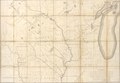
| Description |
English: Accompanied by: Geological report of an examination made in 1834 of the elevated country between the Missouri and Red rivers / by G.W. Featherstonhaugh. Washington : Printed by Gales and Seaton, 1835. (97 p., [1] folded leaf of plates : ill. ; 22 cm.) Available also through the Library of Congress Web site as a raster image. LC copy of accompanying text has multiated ill. |
||
| Title | A map of a portion of the Indian country lying east and west of the Mississippi River to the forty sixth degree of north latitude from personal observation made in the autumn of 1835 and recent authentic documents | ||
| Shelf ID | G4061.E1 1836 .F4 | ||
| Date | |||
| Source | https://www.loc.gov/item/96683128/ | ||
| Author | Featherstonhaugh, George William; United States. Topographical Bureau | ||
| Permission (Reusing this file) |
|
||
| Other versions |
|
||
| Location | United States · Ozark Mountains · Middle West · Arkansas · Missouri | ||
| Part of | American Memory · Catalog · Geography And Map Division · Cultural Landscapes | ||
| Subject | Middle West · Indians Of North America · Geology · Ozark Mountains · United States · Maps · Arkansas · Missouri |

Licensing
[edit]
|
This is a faithful photographic reproduction of a two-dimensional, public domain work of art. The work of art itself is in the public domain for the following reason:
The official position taken by the Wikimedia Foundation is that "faithful reproductions of two-dimensional public domain works of art are public domain".
This photographic reproduction is therefore also considered to be in the public domain in the United States. In other jurisdictions, re-use of this content may be restricted; see Reuse of PD-Art photographs for details. | ||||
File history
Click on a date/time to view the file as it appeared at that time.
| Date/Time | Thumbnail | Dimensions | User | Comment | |
|---|---|---|---|---|---|
| current | 12:42, 19 May 2018 | | 15,397 × 10,733 (14.9 MB) | Fæ (talk | contribs) | LOC Maps https://www.loc.gov/item/96683128/ #11413 |
You cannot overwrite this file.
File usage on Commons
The following page uses this file: