File:A chart of the southern hemisphere, according to the latest discoveries - with the tracks of the Resolution, capn. Cook ; and the Adventure, capn. Furneaux ; from 1772, to 1775. - By George Forster, F.R.S.... - btv1b5970614p (2 of 2).jpg
Jump to navigation
Jump to search

Size of this preview: 565 × 600 pixels. Other resolutions: 226 × 240 pixels | 452 × 480 pixels | 723 × 768 pixels | 964 × 1,024 pixels | 1,929 × 2,048 pixels | 8,152 × 8,656 pixels.
Original file (8,152 × 8,656 pixels, file size: 8.55 MB, MIME type: image/jpeg)
Captions
Captions
Add a one-line explanation of what this file represents
Summary
[edit]| Warning | The original file is very high-resolution. It might not load properly or could cause your browser to freeze when opened at full size. |
|---|
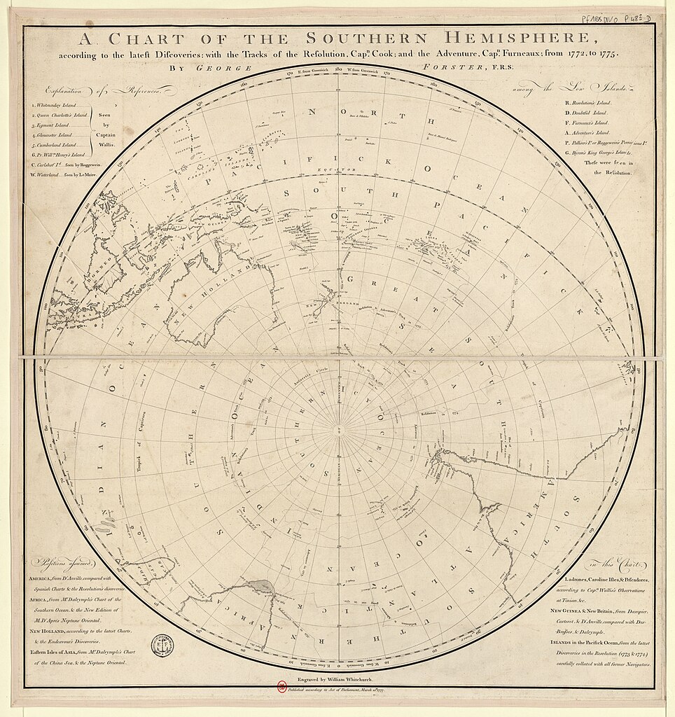
| A chart of the southern hemisphere, according to the latest discoveries : with the tracks of the Resolution, capn. Cook ; and the Adventure, capn. Furneaux ; from 1772, to 1775. / By George Forster, F.R.S. ; Engraved by William Whitchurch
( |
|||||||||||||||||||||||||||
|---|---|---|---|---|---|---|---|---|---|---|---|---|---|---|---|---|---|---|---|---|---|---|---|---|---|---|---|
| Author |
Forster, Johann George (1754-1794). Cartographe Cook, James (1728-1779). Auteur adapté Furneaux, Tobias (1735-1781). Auteur adapté Whitchurch, William (17..-18..? ; graveur). Graveur |
||||||||||||||||||||||||||
| Title |
A chart of the southern hemisphere, according to the latest discoveries : with the tracks of the Resolution, capn. Cook ; and the Adventure, capn. Furneaux ; from 1772, to 1775. / By George Forster, F.R.S. ; Engraved by William Whitchurch |
||||||||||||||||||||||||||
| Description |
Français : Sujet : Cook, James (1728-1779) -- Voyages
Voyages Antarctique -- Côtes Amérique du Sud -- Côtes Australie -- Côtes Monde -- Hémisphère sud Échelle(s) : [Echelle, vers 40° de latitude, 1:30 000 000 environ] Couverture : Monde (parties) Antarctique Australie Langue : anglais Éditeur : [s.n.] (London) |
||||||||||||||||||||||||||
| Date | 1777 | ||||||||||||||||||||||||||
| Dimensions | height: 67 cm (26.3 in); width: 71 cm (27.9 in) | ||||||||||||||||||||||||||
| Collection |
|
||||||||||||||||||||||||||
| References |
Français : Notice de recueil : http://catalogue.bnf.fr/ark:/12148/cb421491424
Appartient à : [Portefeuille 1 du Service hydrographique de la marine consacré aux mappemondes, cartes magnétiques, cartes polaires et planisphères avant 1800] ; 48/2 D Notice du catalogue : http://catalogue.bnf.fr/ark:/12148/cb40610276h |
||||||||||||||||||||||||||
| Source/Photographer |
Français : Bibliothèque nationale de France, département Cartes et plans, GE SH 18 PF 1 BIS DIV 0 P 48/2 D
Bibliothèque nationale de France (2/2) |
||||||||||||||||||||||||||
| Permission (Reusing this file) |
|
||||||||||||||||||||||||||

.jpg&action=edit§ion=1)
.jpg&flash=no)
File history
Click on a date/time to view the file as it appeared at that time.
| Date/Time | Thumbnail | Dimensions | User | Comment | |
|---|---|---|---|---|---|
| current | 13:45, 1 July 2022 | | 8,152 × 8,656 (8.55 MB) | Gzen92Bot (talk | contribs) | Gallica btv1b5970614p |
You cannot overwrite this file.
File usage on Commons
The following 2 pages use this file:
- File:A chart of the southern hemisphere, according to the latest discoveries - with the tracks of the Resolution, capn. Cook ; and the Adventure, capn. Furneaux ; from 1772, to 1775. - By George Forster, F.R.S.... - btv1b5970614p (2 of 2).jpg
- File:A chart of the southern hemisphere, according to the latest discoveries - with the tracks of the Resolution, capn. Cook ; and the Adventure, capn. Furneaux ; from 1772, to 1775. - By George Forster, F.R.S. ;... - btv1b5970614p (2 of 2).jpg (file redirect)
.jpg)
.jpg&redirect=no)
.jpg&oldid=881350442)