File:A chart of North and South America, including the Atlantic and Pacific Oceans, with the nearest coasts of Europe, Africa and Asia. LOC 75692293-4.jpg
Jump to navigation
Jump to search

Size of this preview: 761 × 600 pixels. Other resolutions: 305 × 240 pixels | 609 × 480 pixels | 975 × 768 pixels | 1,280 × 1,009 pixels | 2,560 × 2,017 pixels | 8,134 × 6,409 pixels.
Original file (8,134 × 6,409 pixels, file size: 6.39 MB, MIME type: image/jpeg)
Captions
Captions
Add a one-line explanation of what this file represents
Summary
[edit]| Description |
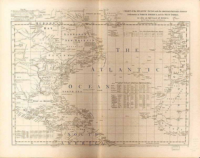
English: Scale ca. 1:20,000,000. Title from sheets 1 and 2. Prime meridian: London and Ferro. Relief shown pictorially. Shows nautical exploration routes. "Published according to act of Parliament, Feb. 19, 1753, by T. Jefferys, ... at the corner of St. Martins Lane Charing Cross." Includes text, historical and geographical notes, and tables of comparative astronomical observations. Accompanied by J. Green's: Remarks, in support of the new chart of North and South America; in six sheets. 48 p. Available also through the Library of Congress Web site as a raster image. Vault AACR2: 100; 651/1; 651/2 |
||
| Title | A chart of North and South America, including the Atlantic and Pacific Oceans, with the nearest coasts of Europe, Africa and Asia. | ||
| Shelf ID | G3290 s20000 .J4 | ||
| Parent | https://www.loc.gov/resource/g3290m.gct00395/ | ||
| Sheet title | Chart of the Atlantic Ocean with the British, French & Spanish settlements | ||
| Date | |||
| Source | https://www.loc.gov/item/75692293/ | ||
| Author | Jefferys, Thomas; Green, John | ||
| Permission (Reusing this file) |
|
||
| Other versions |
|
||
| Location | America. · America | ||
| Part of | American Memory · General Maps · Catalog · Geography And Map Division | ||
| Subject | Maps · Early Works To 1800 · America · Discovery And Exploration |


Licensing
[edit]
|
This is a faithful photographic reproduction of a two-dimensional, public domain work of art. The work of art itself is in the public domain for the following reason:
The official position taken by the Wikimedia Foundation is that "faithful reproductions of two-dimensional public domain works of art are public domain".
This photographic reproduction is therefore also considered to be in the public domain in the United States. In other jurisdictions, re-use of this content may be restricted; see Reuse of PD-Art photographs for details. | ||||
File history
Click on a date/time to view the file as it appeared at that time.
| Date/Time | Thumbnail | Dimensions | User | Comment | |
|---|---|---|---|---|---|
| current | 14:41, 15 July 2018 | | 8,134 × 6,409 (6.39 MB) | Fæ (talk | contribs) | LOC Maps multisheet https://www.loc.gov/item/75692293/ sheet 4 of 6 #469 |
You cannot overwrite this file.
File usage on Commons
The following page uses this file: