File:A Thousand Islands in South Korea.jpeg

Original file (4,509 × 4,764 pixels, file size: 4.8 MB, MIME type: image/jpeg)
Captions
Captions
Summary
[edit]
| Description |
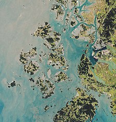
Located along the southwest coast of South Korea, Sinan County attracts people from many walks of life. Its world-renowned tidal flats host unique marine life as well a thriving salt production industry. Meanwhile, purple-painted islands draw tourists from around the country. The images on this page show portions of Sinan County, or Shinan-gun, on October 15, 2020. The images were acquired by the Operational Land Imager (OLI) on the Landsat 8 satellite. Sinan County includes more than 1,000 islands, about a quarter of all islands in the country. The majority are surrounded by shallow tidal flats that are alternately covered or exposed by the rise and fall of tides. Depending on the time of the year, the flats can be muddier, sandier, or a combination of both. Finer mud tends to build in the zones during the summer, then erodes in the winter. Monsoons and strong waves in the winter create sandier flats. The tidal flats, or getbol in Korean, are highly productive ecosystems. The mineral-rich sediments are full of microorganisms that attract marine animals such as clams and mud octopuses. The flats serve also as an important stopover for many migratory birds. Reclaimed mudflats are also used for commercial salt production. The region’s fresh air, clean seawater, and abundant sunshine create prime conditions for making salt. Salt production begins by storing sea water in reservoirs and moving it to evaporation ponds (appearing as checkered fields) to naturally increase the water’s salinity with the help of the Sun and wind. On crystallization ponds, the saline water turns into salt crystals, which are stored in silos for two to three years to remove the bitter-tasting solution and improve the taste. Shinean sea salt contains low concentrations of sodium chloride, but relatively high amounts of moisture, calcium, potassium, magnesium, and sulfuric acid ions that help bring out the flavor in traditional Korean foods. |
| Date | |
| Source | https://earthobservatory.nasa.gov/images/148136/a-thousand-islands-in-south-korea |
| Author | NASA Earth Observatory images by Lauren Dauphin, using Landsat data from the U.S. Geological Survey. Story by Kasha Patel. |
Licensing
[edit]
| This file is in the public domain in the United States because it was solely created by NASA. NASA copyright policy states that "NASA material is not protected by copyright unless noted". (See Template:PD-USGov, NASA copyright policy page or JPL Image Use Policy.) | ||
 |
Warnings:
|
File history
Click on a date/time to view the file as it appeared at that time.
| Date/Time | Thumbnail | Dimensions | User | Comment | |
|---|---|---|---|---|---|
| current | 00:46, 25 May 2021 | | 4,509 × 4,764 (4.8 MB) | StellarHalo (talk | contribs) | {{Information |Description=Located along the southwest coast of South Korea, Sinan County attracts people from many walks of life. Its world-renowned tidal flats host unique marine life as well a thriving salt production industry. Meanwhile, purple-painted islands draw tourists from around the country. The images on this page show portions of Sinan County, or Shinan-gun, on October 15, 2020. The images were acquired by the Operational Land Imager (OLI) on the Landsat 8 satellite. Sinan Coun... |
You cannot overwrite this file.
File usage on Commons
There are no pages that use this file.