File:A Plan of the coast from Cape Anne in north latitude 42⁰42ʹ & 70⁰33ʹ west longitude from Greenwich- ... to Isle Scattery in long. 50⁰40ʹ & latitude 46⁰ (0)ʹ north, ... including the isle of Sable. LOC 74694110.jpg
Jump to navigation
Jump to search

Size of this preview: 800 × 196 pixels. Other resolutions: 320 × 78 pixels | 640 × 157 pixels | 1,024 × 251 pixels | 1,280 × 313 pixels | 2,560 × 627 pixels | 25,845 × 6,330 pixels.
Original file (25,845 × 6,330 pixels, file size: 18.18 MB, MIME type: image/jpeg)
Captions
Captions
Add a one-line explanation of what this file represents
Summary
[edit]| Warning | The original file is very high-resolution. It might not load properly or could cause your browser to freeze when opened at full size. |
|---|
| Description |
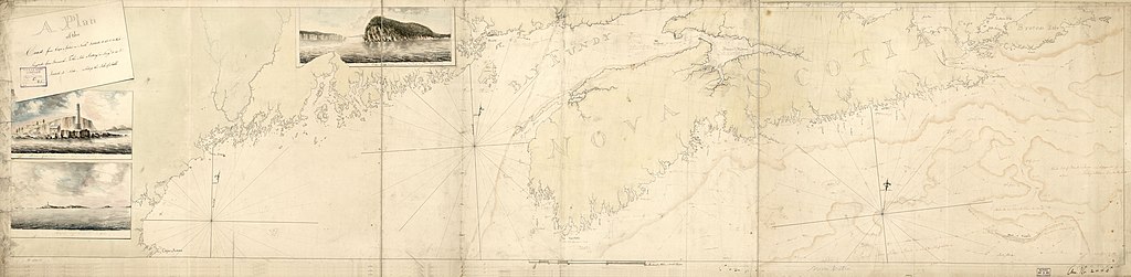
English: Scale ca. 1:500,000. Manuscript, red and black ink and watercolor, some letters and features roughed in pencil. Relief shown by hachures. Shoals shown with a line of pale red wash. "Acc. no. 2442." Three paintings of shoreline profiles: Lighthouse of Boston from the channel sailing out.--Halifax light house west 3 miles.--Cape Babtist a lofty promontory at the head of Bay Fundy. Bearing WBN 3 miles. Available also through the Library of Congress Web site as a raster image. Vault AACR2 |
||
| Title | A Plan of the coast from Cape Anne in north latitude 42⁰42ʹ & 70⁰33ʹ west longitude from Greenwich: ... to Isle Scattery in long. 50⁰40ʹ & latitude 46⁰ [0]ʹ north, ... including the isle of Sable. | ||
| Shelf ID | G3321.P5 1775 .P5 | ||
| Date | |||
| Source | https://www.loc.gov/item/74694110/ | ||
| Author | Unknown author | ||
| Permission (Reusing this file) |
|
||
| Other versions |
|
||
| Location | Canada · United States · Maritime Provinces · New England · North America · Atlantic Coast | ||
| Part of | Military Battles And Campaigns · American Memory · Catalog · Geography And Map Division · American Revolution And Its Era: Maps And Charts Of North America And The West Indies, 1750-1789 | ||
| Subject | Canada · United States · Maritime Provinces · Atlantic Coast (North America) · New England · Coasts · Nautical Charts · North America · Maps · Early Works To 1800 · Atlantic Coast |

%CA%B9_north,_..._including_the_isle_of_Sable._LOC_74694110.jpg&action=edit§ion=1)
%CA%B9_north,_..._including_the_isle_of_Sable._LOC_74694110.jpg&flash=no)
Licensing
[edit]%CA%B9_north,_..._including_the_isle_of_Sable._LOC_74694110.jpg&action=edit§ion=2)
|
This is a faithful photographic reproduction of a two-dimensional, public domain work of art. The work of art itself is in the public domain for the following reason:
The official position taken by the Wikimedia Foundation is that "faithful reproductions of two-dimensional public domain works of art are public domain".
This photographic reproduction is therefore also considered to be in the public domain in the United States. In other jurisdictions, re-use of this content may be restricted; see Reuse of PD-Art photographs for details. | ||||
File history
Click on a date/time to view the file as it appeared at that time.
| Date/Time | Thumbnail | Dimensions | User | Comment | |
|---|---|---|---|---|---|
| current | 19:36, 2 June 2018 | 25,845 × 6,330 (18.18 MB) | Fæ (talk | contribs) | LOC Maps https://www.loc.gov/item/74694110/ #2732 |
You cannot overwrite this file.
File usage on Commons
The following page uses this file:
ʹ_north,_..._including_the_isle_of_Sable._LOC_74694110.jpg&oldid=776477558)