File:A Chart of the North Sea - btv1b5973360t (2 of 2).jpg
Jump to navigation
Jump to search

Size of this preview: 800 × 580 pixels. Other resolutions: 320 × 232 pixels | 640 × 464 pixels | 1,024 × 742 pixels | 1,280 × 928 pixels | 2,560 × 1,856 pixels | 10,704 × 7,760 pixels.
Original file (10,704 × 7,760 pixels, file size: 10.87 MB, MIME type: image/jpeg)
Captions
Captions
Add a one-line explanation of what this file represents
Summary
[edit]| Warning | The original file is very high-resolution. It might not load properly or could cause your browser to freeze when opened at full size. |
|---|
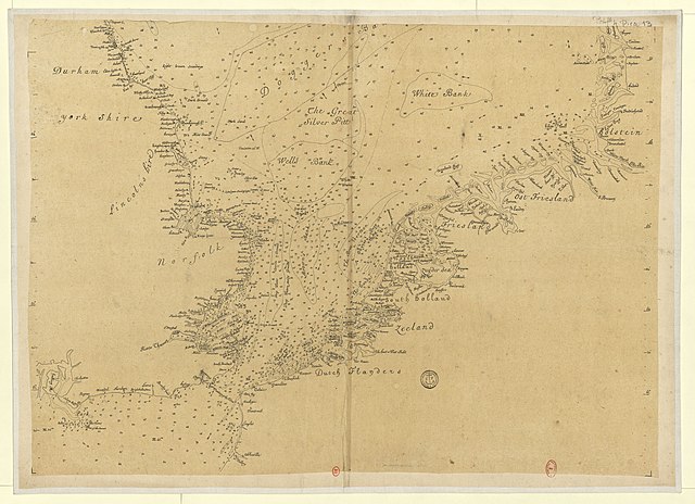
| A Chart of the North Sea
( |
|||||||||||||||||||||||||||
|---|---|---|---|---|---|---|---|---|---|---|---|---|---|---|---|---|---|---|---|---|---|---|---|---|---|---|---|
| Title |
A Chart of the North Sea |
||||||||||||||||||||||||||
| Description |
Français : Sujet : Mer du Nord
Échelle(s) : Scale of English and French Leagues 20 to a Degree, 40 [=Om. 214 ; 1:1 040 000 environ] Couverture : Monde Océan Atlantique Nord Langue : anglais Éditeur : [s.n.] |
||||||||||||||||||||||||||
| Date | 1750 | ||||||||||||||||||||||||||
| Collection |
|
||||||||||||||||||||||||||
| References |
Français : Notice de recueil : http://catalogue.bnf.fr/ark:/12148/cb42209761d
Appartient à : [Portefeuille 4 du Service hydrographique de la marine consacré à la mer du Nord] ; 13 Notice du catalogue : http://catalogue.bnf.fr/ark:/12148/cb40630582p |
||||||||||||||||||||||||||
| Source/Photographer |
Français : Collections BnF, GESH18PF4P13
Bibliothèque nationale de France (2/2) |
||||||||||||||||||||||||||
| Permission (Reusing this file) |
|
||||||||||||||||||||||||||

.jpg&action=edit§ion=1)
.jpg&flash=no)
File history
Click on a date/time to view the file as it appeared at that time.
| Date/Time | Thumbnail | Dimensions | User | Comment | |
|---|---|---|---|---|---|
| current | 14:13, 21 July 2022 | | 10,704 × 7,760 (10.87 MB) | Gzen92Bot (talk | contribs) | Gallica btv1b5973360t |
You cannot overwrite this file.
File usage on Commons
The following page uses this file:
.jpg)
.jpg&oldid=825563483)