File:AWASE AIRFIELD in 1949.jpg

Original file (5,068 × 6,287 pixels, file size: 3.67 MB, MIME type: image/jpeg)
Captions
Captions
Summary
[edit]
| Description |
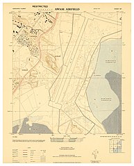
English: "......The AWASE area was captured during the first week of the Battle of Okinawa. The area was then surveyed for possible airbase construction in late April 1945 and the 36th Naval Construction Battalion commenced construction of a 5000 ft fighter airstrip there on 23 April.
Construction of the airfield was delayed by torrential rain in late May and early June and the diversion of the heavy earth-moving equipment to the maintenance of supply roads. On 30 June 1945 the base was declared operational and the first aircraft from Marine Air Group 33 (MAG-33) landed at the airfield. By March 1977 --- five years after Okinawa's reversion to Japan --- all of the airfield area had been returned to Japanese control. All that remains of the original Navy / Marine complex today is the U.S. Navy's Awase Communication Station at the tip of the Awase peninsula, right next to the present day SAM'S BY THE SEA restaurant......" --- en.wikipedia.org/wiki/Awase_Airfield Largely forgotten, and completely unknown by the generations of Okinawans born and living on the spot today, the AWASE AIRFIELD still lingers in the memories of many old-timers on Okinawa. The Airfield also figures in some older books about Okinawa, including references made to it in THE TEAHOUSE OF THE AUGUST MOON, the popular 1951 novel by Vern Sneider. The Airfield is also referenced a few times in the prize-winning, 1971 Novella by Higashi Mineo OKINAWA NO SHOUNEN. [Later translated into English by Steve Rabson, and published in 1989 as CHILD OF OKINAWA ]. The old Airfield and all the open parking bays associated with it are now long gone, but the broad landing strip affected the way that later roads and infrastructure were designed and laid down. Interestingly, a huge chunk of the runway area is visible on the January 4th, 2015 GOOGLE EARTH image seen HERE : ♥ 26°18'58.37"N 127°49'29.14"E This naked [in 2015], north-central spot along the old Airstrip hosted the AWASE HYPER-MART and TOYS "Я" US, until the complex went out of business a few years ago, and was razed. The North end of the runway is buried under a spot just south-east of a couple of school-yards HERE : ♥ 26°19'15.06"N 127°49'36.40"E The South end of the runway sat in what is now the middle of the Sports Stadium HERE : ♥ 26°18'30.77"N 127°49'16.16"E For those who love these old maps, and want to use the above post to superimpose over modern maps or aerial photographs of Okinawa, please use the above three coordinates to get started. If you are a true map maniac, note that this is a wartime GPO printed document in the PUBIC DOMAIN. Feel free to download my largest sizes for your own use, personal study, and safe-keeping on your own hard drive : LARGE SIZES : www.flickr.com/photos/okinawa-soba/23990406574/sizes/l BOOK NOTE : The Steve Rabson-translated Novella, CHILD OF OKINAWA, is pictured on this site : ♥ ieas.berkeley.edu/publications/jrm10.html Professor Rabson was stationed at CAMP HENOKO back in the 1960s, and was already an "old hand" concerning Okinawa many years before I showed up in 1973. Cheers ! |
| Date | |
| Source | https://www.flickr.com/photos/okinawa-soba/23990406574/ |
| Author | Okinawa Soba (Rob) |
Licensing
[edit]
| This image was originally posted to Flickr by Okinawa Soba (Rob) at https://flickr.com/photos/24443965@N08/23990406574. It was reviewed on 20 April 2024 by FlickreviewR 2 and was confirmed to be licensed under the terms of the Public Domain Mark. |
This work has been released into the public domain by the author on Flickr, where the author has declared it as a "Public Domain Work" and tagged it with the Creative Commons Public Domain Mark.
|
||
The Public Domain Mark (PDM) is not a copyright license, but a symbol used to indicate that a work is in the public domain. When it is applied by the author or the copyright holder, community consensus has decided such works as being public domain in the US and countries where it is legally possible to release own work to the public domain. In the countries where this is not possible, the copyright status of the work remains undetermined.
| ||
If a file is tagged with Public Domain Mark by someone other than the author or the copyright holder, a more specific copyright tag such as one found at Commons:Copyright tags/General public domain must be applied. If this is your own work, please use {{Cc-zero}} instead.
|
File history
Click on a date/time to view the file as it appeared at that time.
| Date/Time | Thumbnail | Dimensions | User | Comment | |
|---|---|---|---|---|---|
| current | 05:31, 26 February 2022 | | 5,068 × 6,287 (3.67 MB) | Alain Parks (talk | contribs) | Uploaded a work by Okinawa Soba (Rob) from https://www.flickr.com/photos/okinawa-soba/23990406574/ with UploadWizard |
You cannot overwrite this file.
File usage on Commons
There are no pages that use this file.
File usage on other wikis
The following other wikis use this file:
- Usage on ja.wikipedia.org