File:AMH-8638-NA Small map of Valentine's Bay in the Le Maire Strait.jpg
Original file (2,400 × 1,874 pixels, file size: 551 KB, MIME type: image/jpeg)
Captions
Captions
Summary
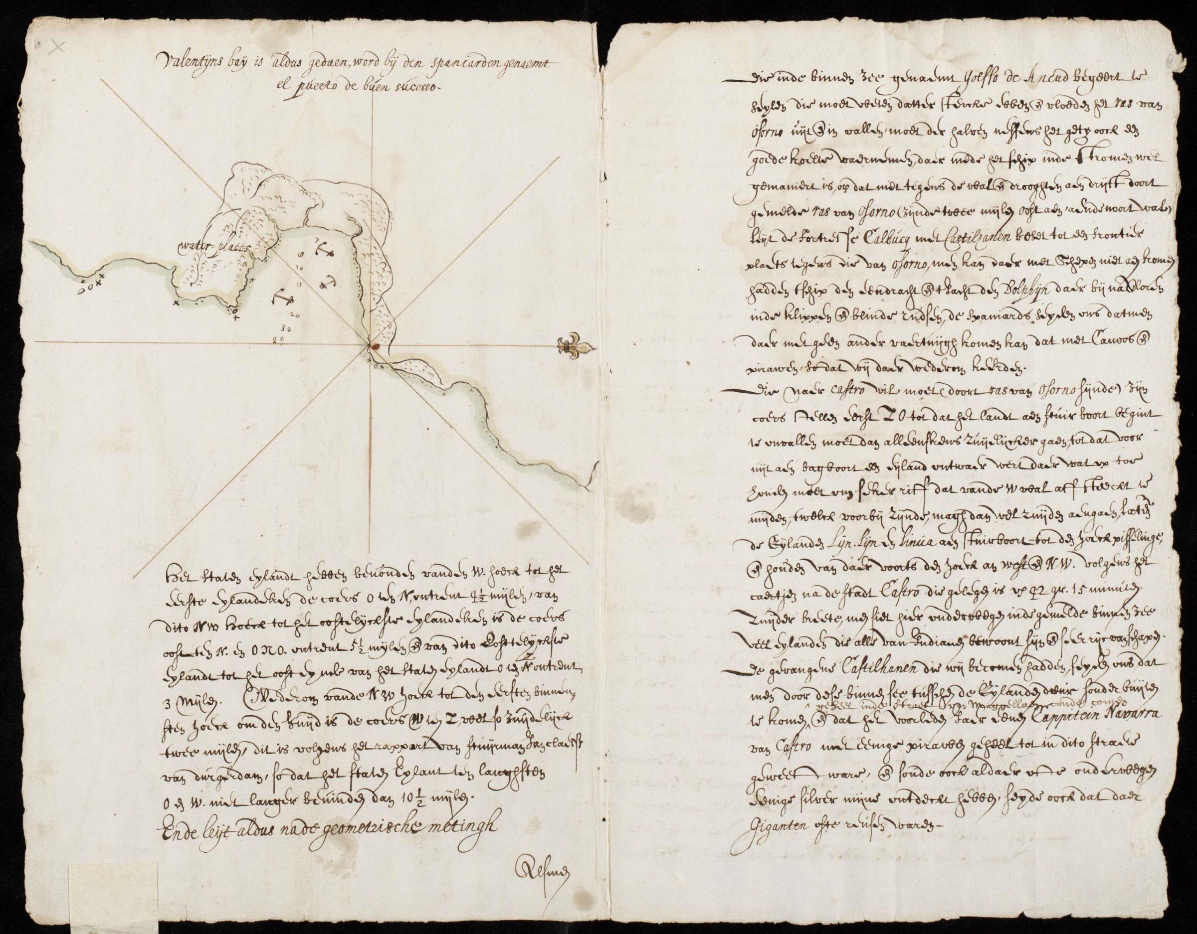
[edit]Nederlands: Kaartje van de Valentijnsbaai in Straat Le Maire
English: Small map of Valentine's Bay in the Le Maire Strait( |
||||||||||||||||||||||||
|---|---|---|---|---|---|---|---|---|---|---|---|---|---|---|---|---|---|---|---|---|---|---|---|---|
| Author |
Nederlands: E. Herckmans (landmeter / kaartenmaker)
English: E. Herckmans (land surveyor / mapmaker) |
|||||||||||||||||||||||
| Title |
Nederlands: Kaartje van de Valentijnsbaai in Straat Le Maire
English: Small map of Valentine's Bay in the Le Maire Strait |
|||||||||||||||||||||||
| Description |
Nederlands: Kaartje van de Valentijnsbaai in Straat Le Maire.
Titel in Catalogus Leupe (NA): Landverkenningen zoo wel van de Kust, als van het land te wederzyden in Straat Le Maire, en opdoening van Straat. [NB: Deze titel hoort bij Nationaal Archief, Den Haag, inv. nr. VEL0729]. Valentijns baij is aldus gedaen, word bij den spaniarden genaemt el puerto de buen sucesso. Straat Le Maire werd ontdekt tijdens de reis van Willem Schouten en Jacob Le Maire. De reis werd in 1615 uitgerust door de vader van Le Maire voor de Australische Compagnie. Deze compagnie probeerde het octrooi van de VOC te omzeilen door een andere route naar Indonesië te vinden. Dit lukte Schouten en Le Maire, door om Vuurland heen te zeilen, in plaats van door de straat Magelaen. Het mocht niet baten: eenmaal in Batavia werden ze niet geloofd en het overgebleven schip, de Eendracht, werd met lading in beslag genomen.English: Diminutive map of Valentine's Bay in the Le Maire Strait.
Title in the Leupe Catalogue (NA): Landverkenningen zoo wel van de Kust, als van het land te wederzyden in Straat Le Maire, en opdoening van Straat. [NB: This title pertains to National Archives, The Hague, inv. nr. VEL0729]. Valentijns baij is aldus gedaen, word bij den spaniarden genaemt el puerto de buen sucesso. The Le Maire Strait was discovered during the expedition undertaken by Willem Schouten and Jacob Le Maire. The expedition was fitted out in 1615 by Le Maire's father for the Australian Company. This company attempted to circumvent the VOC's patent by opening up another route to Indonesia. Schouten and Le Maire succeeded in their quest by circumnavigating Vuurland rather than sailing through the Magellan Strait. But to no avail: once they arrived in Batavia, their story was not believed and their remaining vessel de Eendracht was confiscated along with its cargo. |
|||||||||||||||||||||||
| Date | 1631 | |||||||||||||||||||||||
| Medium |
Nederlands: pen op papier
English: pen on paper |
|||||||||||||||||||||||
| Dimensions | height: 21 cm (8.2 in); width: 20 cm (7.8 in) | |||||||||||||||||||||||
| Collection |
|
|||||||||||||||||||||||
| Accession number |
NL-HaNA_4.VEL_730 (old number: VEL0730) |
|||||||||||||||||||||||
| Inscriptions |
Valentijns baij is aldus gedaen, word bij den spaniarden genaemt el puerto de buen sucesso
|
|||||||||||||||||||||||
| Notes |
English: Subjects: chart / map / plan
Nederlands: Onderwerpen: plattegrond / kaart |
|||||||||||||||||||||||
| Source/Photographer |
|
|||||||||||||||||||||||
| Permission (Reusing this file) |
|
|||||||||||||||||||||||

File history
Click on a date/time to view the file as it appeared at that time.
| Date/Time | Thumbnail | Dimensions | User | Comment | |
|---|---|---|---|---|---|
| current | 10:31, 11 June 2014 | | 2,400 × 1,874 (551 KB) | HuskyBot (talk | contribs) | == {{int:filedesc}} == {{Artwork |title = {{nl|1=Kaartje van de Valentijnsbaai in Straat Le Maire}} {{en|1=Small map of Valentine's Bay in the Le Maire Strait}} |description = {{nl|1=Kaartje van de Valentijnsba... |
You cannot overwrite this file.
File usage on Commons
The following page uses this file: