File:AMH-8162-KB Map of the mouth of the Senegal River and a floorplan of Fort St. Joseph in Galam.jpg

Original file (2,400 × 834 pixels, file size: 414 KB, MIME type: image/jpeg)
Captions
Captions
Summary
[edit]Nederlands: Kaart van de monding van de rivier Senegal en een plattegrond van fort St. Joseph in Galam
English: Map of the mouth of the Senegal River and a floorplan of Fort St. Joseph in Galam( |
|||||||||||||||||||||
|---|---|---|---|---|---|---|---|---|---|---|---|---|---|---|---|---|---|---|---|---|---|
| Author |
Creator:D' Anville Creator:G. Child Nederlands: Anoniem / Anonymous (uitgever), d' Anville (landmeter / kaartenmaker), G. Child (graveur / etser)
English: Anoniem / Anonymous (publisher), d' Anville (land surveyor / mapmaker), G. Child (engraver / etcher) |
||||||||||||||||||||
| Title |
Nederlands: Kaart van de monding van de rivier Senegal en een plattegrond van fort St. Joseph in Galam
English: Map of the mouth of the Senegal River and a floorplan of Fort St. Joseph in Galam |
||||||||||||||||||||
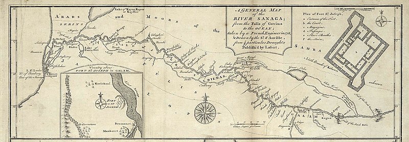
| Description |
Nederlands: Kaart van de monding van de rivier Senegal en twee plattegronden van fort St. Joseph in Galam.
A General Map of the River Sanaga; from the Falls of Govina to the Ocean. Country about fort St. Joseph in Galam. Plan of Fort St. Joseph. Legenda: a-f.English: Map of the mouth of the Senegal River and two plans of Fort St. Joseph in Galam.
A General Map of the River Sanaga; from the Falls of Govina to the Ocean. Country about fort St. Joseph in Galam. Plan of Fort St. Joseph. Key: a-f. |
||||||||||||||||||||
| Date | 1745 | ||||||||||||||||||||
| Medium |
Nederlands: gravure op papier
English: engraving on paper |
||||||||||||||||||||
| Dimensions | height: 28 cm (11 in); width: 10 cm (3.9 in) | ||||||||||||||||||||
| Collection |
|
||||||||||||||||||||
| Accession number |
3032 B 10, to. p. 45 |
||||||||||||||||||||
| Inscriptions |
A General Map of the River Sanaga; from the Falls of Govina to the Ocean
author: G. Child Sculpt [signatuur onder andere kaart op dezelfde pagina] |
||||||||||||||||||||
| Notes |
English: Subjects: chart / map / plan, compass / dial, banderole / cartouche / ornamentation, fortification, building
Nederlands: Onderwerpen: plattegrond / kaart, kompas / windroos, banderol / cartouche / versiering, vesting, gebouw
English: Post: this image is related to a WIC trading post called St. Louis |
||||||||||||||||||||
| Source/Photographer |
|
||||||||||||||||||||
| Permission (Reusing this file) |
|
||||||||||||||||||||

| Object location | | View this and other nearby images on: OpenStreetMap |
|---|
File history
Click on a date/time to view the file as it appeared at that time.
| Date/Time | Thumbnail | Dimensions | User | Comment | |
|---|---|---|---|---|---|
| current | 15:37, 10 June 2014 | 2,400 × 834 (414 KB) | HuskyBot (talk | contribs) | == {{int:filedesc}} == {{Artwork |title = {{nl|1=Kaart van de monding van de rivier Senegal en een plattegrond van fort St. Joseph in Galam}} {{en|1=Map of the mouth of the Senegal River and a floorplan of Fort St. Jo... |
You cannot overwrite this file.
File usage on Commons
The following page uses this file: