File:AMH-7986-KB Map of the island of Onrust.jpg
Jump to navigation
Jump to search

Size of this preview: 800 × 575 pixels. Other resolutions: 320 × 230 pixels | 640 × 460 pixels | 1,024 × 736 pixels | 1,280 × 920 pixels | 2,400 × 1,725 pixels.
Original file (2,400 × 1,725 pixels, file size: 806 KB, MIME type: image/jpeg)
Captions
Captions
Add a one-line explanation of what this file represents
Summary
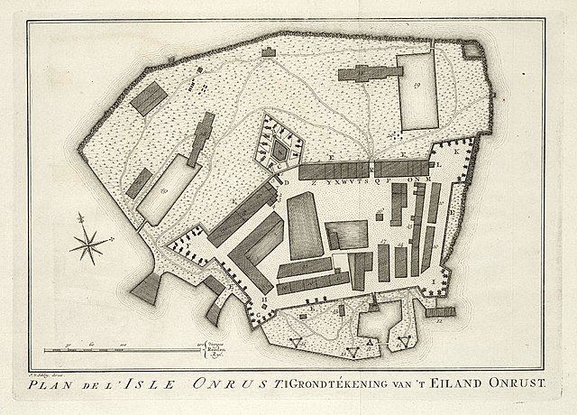
[edit]Nederlands: Plattegrond van het Eiland Onrust
English: Map of the island of Onrust( |
|||||||||||||||||||||||||||||||||||||||||||||
|---|---|---|---|---|---|---|---|---|---|---|---|---|---|---|---|---|---|---|---|---|---|---|---|---|---|---|---|---|---|---|---|---|---|---|---|---|---|---|---|---|---|---|---|---|---|
| Author |
Nederlands: Pierre d' Hondt (uitgever), Jacobus van der Schley (direxit)
English: Pierre d' Hondt (publisher), Jacobus van der Schley (direxit) |
||||||||||||||||||||||||||||||||||||||||||||
| Title |
Nederlands: Plattegrond van het Eiland Onrust
English: Map of the island of Onrust |
||||||||||||||||||||||||||||||||||||||||||||
| Description |
Nederlands: Plattegrond van het Eiland Onrust.
Plan de l'Isle Onrust. Grondtékening van 't Eiland Onrust. Op de kaart staan legendanummers aangegeven. Deze zijn echter niet verklaard.English: Map of the island of Onrust. Plan de l'Isle Onrust.
Grondtékening van 't Eiland Onrust. The map is marked with reference numbers, but there is no accompanying key. |
||||||||||||||||||||||||||||||||||||||||||||
| Date | 1763 | ||||||||||||||||||||||||||||||||||||||||||||
| Medium |
Nederlands: gravure op papier
English: engraving on paper |
||||||||||||||||||||||||||||||||||||||||||||
| Dimensions | height: 21.5 cm (8.4 in); width: 15.5 cm (6.1 in) | ||||||||||||||||||||||||||||||||||||||||||||
| Collection |
|
||||||||||||||||||||||||||||||||||||||||||||
| Accession number |
693 C 6 dl XVII, na p. 266 |
||||||||||||||||||||||||||||||||||||||||||||
| Inscriptions |
Plan de l'Isle Onrust / Grondtékening van 't Eiland Onrust
author: J. v. Schley, direx. |
||||||||||||||||||||||||||||||||||||||||||||
| Notes |
English: Subjects: fortification, building, chart / map / plan, compass / dial, key
Nederlands: Onderwerpen: vesting, gebouw, plattegrond / kaart, kompas / windroos, legenda |
||||||||||||||||||||||||||||||||||||||||||||
| Source/Photographer |
|
||||||||||||||||||||||||||||||||||||||||||||
| Permission (Reusing this file) |
|
||||||||||||||||||||||||||||||||||||||||||||

File history
Click on a date/time to view the file as it appeared at that time.
| Date/Time | Thumbnail | Dimensions | User | Comment | |
|---|---|---|---|---|---|
| current | 14:59, 10 June 2014 | | 2,400 × 1,725 (806 KB) | HuskyBot (talk | contribs) | == {{int:filedesc}} == {{Artwork |title = {{nl|1=Plattegrond van het Eiland Onrust}} {{en|1=Map of the island of Onrust}} |description = {{nl|1=Plattegrond van het Eiland Onrust. ''Plan de l'Isle Onrust''. ''... |
You cannot overwrite this file.
File usage on Commons
The following page uses this file:
File usage on other wikis
The following other wikis use this file:
- Usage on nl.wikipedia.org