File:AMH-7958-KB Map of the Cape of Good Hope.jpg
Original file (2,400 × 1,899 pixels, file size: 822 KB, MIME type: image/jpeg)
Captions
Captions
Summary
[edit]Nederlands: Kaart van de Kaap de Goede Hoop
English: Map of the Cape of Good Hope( |
||||||||||||||||||||||||||||||||||||||||||||||||||||||||||||||||
|---|---|---|---|---|---|---|---|---|---|---|---|---|---|---|---|---|---|---|---|---|---|---|---|---|---|---|---|---|---|---|---|---|---|---|---|---|---|---|---|---|---|---|---|---|---|---|---|---|---|---|---|---|---|---|---|---|---|---|---|---|---|---|---|---|
| Author |
Nederlands: Jacques Nicolas Bellin (landmeter / kaartenmaker), Pierre d' Hondt (uitgever), Jacobus van der Schley (direxit)
English: Jacques Nicolas Bellin (land surveyor / mapmaker), Pierre d' Hondt (publisher), Jacobus van der Schley (direxit) |
|||||||||||||||||||||||||||||||||||||||||||||||||||||||||||||||
| Title |
Nederlands: Kaart van de Kaap de Goede Hoop
English: Map of the Cape of Good Hope |
|||||||||||||||||||||||||||||||||||||||||||||||||||||||||||||||
| Description |
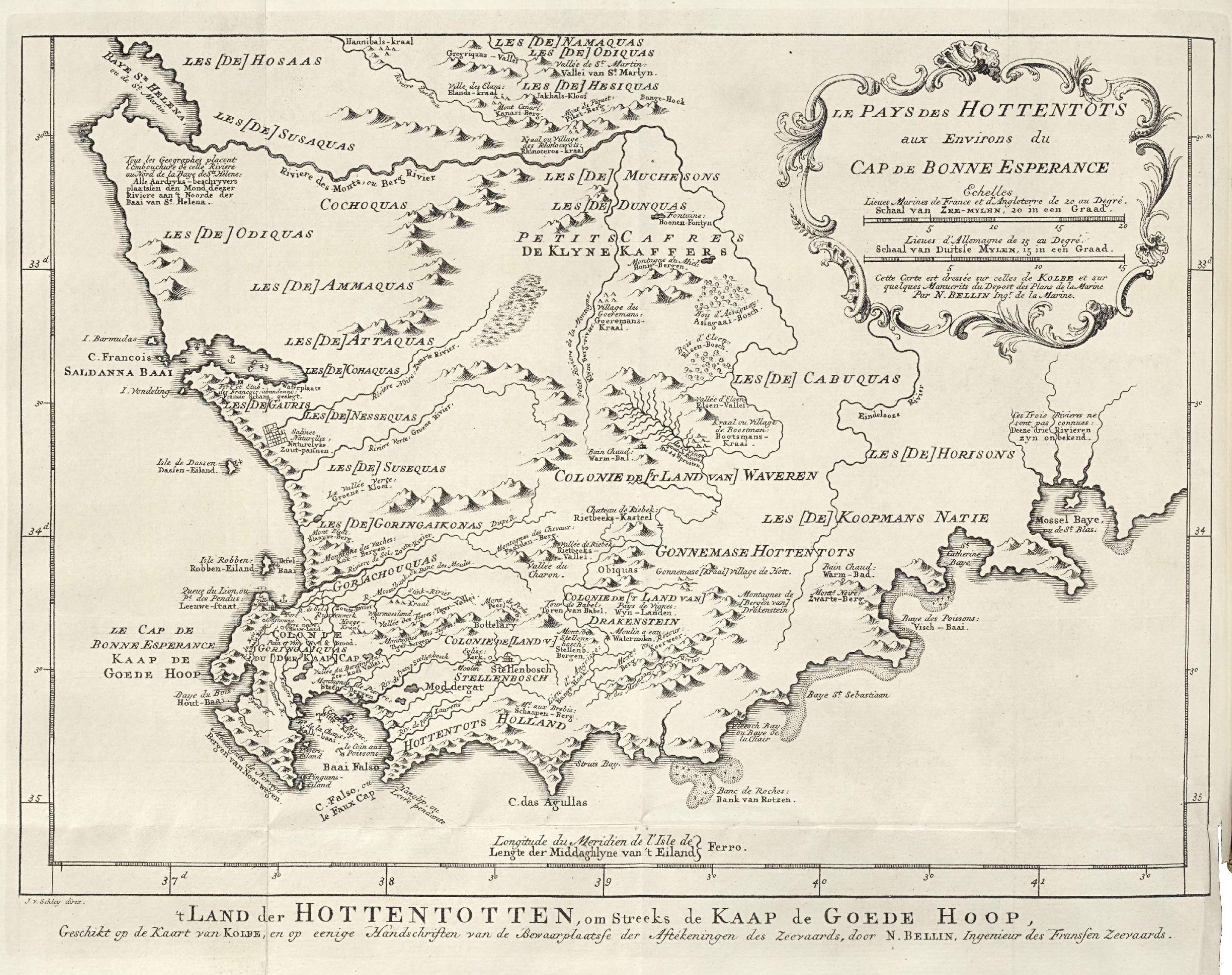
Nederlands: Kaart van de Kaap de Goede Hoop.
't Land der Hottentotten, omstreeks de Kaap de Goede Hoop / Geschikt op de Kaart van Kolbe, en op eenige Handschriften van de Bewaarplaatse der Aftekeningen des Zeevaards, door N. Bellin, Ingenieur des Fransen Zeevaards. Le Pays des Hottentots aux Environs du Cap de Bonne Esperance. Cette Carte est dressée sur celle de Kolbe et sur quelques Manucrits du Depot des Plans de la Marine Par N. Bellin Ing:r de la Marine.English: Map of the Cape of Good Hope.
't Land der Hottentotten, omstreeks de Kaap de Goede Hoop / Geschikt op de Kaart van Kolbe, en op eenige Handschriften van de Bewaarplaatse der Aftekeningen des Zeevaards, door N. Bellin, Ingenieur des Fransen Zeevaards. Le Pays des Hottentots aux Environs du Cap de Bonne Esperance. Cette Carte est dressée sur celle de Kolbe et sur quelques Manucrits du Depot des Plans de la Marine Par N. Bellin Ing:r de la Marine. |
|||||||||||||||||||||||||||||||||||||||||||||||||||||||||||||||
| Date | 1747 | |||||||||||||||||||||||||||||||||||||||||||||||||||||||||||||||
| Medium |
Nederlands: gravure op papier
English: engraving on paper |
|||||||||||||||||||||||||||||||||||||||||||||||||||||||||||||||
| Dimensions | height: 24 cm (9.4 in); width: 19 cm (7.4 in) | |||||||||||||||||||||||||||||||||||||||||||||||||||||||||||||||
| Collection |
|
|||||||||||||||||||||||||||||||||||||||||||||||||||||||||||||||
| Accession number |
693 C 6 dl VI, na p. 433 |
|||||||||||||||||||||||||||||||||||||||||||||||||||||||||||||||
| Inscriptions |
't Land der Hottentotten, omstreeks de Kaap de Goede Hoop
author: J. v. Schley direx. |
|||||||||||||||||||||||||||||||||||||||||||||||||||||||||||||||
| Notes |
English: Subjects: chart / map / plan, banderole / cartouche / ornamentation
Nederlands: Onderwerpen: plattegrond / kaart, banderol / cartouche / versiering
English: Post: this image is related to a VOC trading post called Saldanha |
|||||||||||||||||||||||||||||||||||||||||||||||||||||||||||||||
| Source/Photographer |
|
|||||||||||||||||||||||||||||||||||||||||||||||||||||||||||||||
| Permission (Reusing this file) |
|
|||||||||||||||||||||||||||||||||||||||||||||||||||||||||||||||

| Object location | | View this and other nearby images on: OpenStreetMap |
|---|
File history
Click on a date/time to view the file as it appeared at that time.
| Date/Time | Thumbnail | Dimensions | User | Comment | |
|---|---|---|---|---|---|
| current | 14:53, 10 June 2014 | | 2,400 × 1,899 (822 KB) | HuskyBot (talk | contribs) | == {{int:filedesc}} == {{Artwork |title = {{nl|1=Kaart van de Kaap de Goede Hoop}} {{en|1=Map of the Cape of Good Hope}} |description = {{nl|1=Kaart van de Kaap de Goede Hoop. '''t Land der Hottentotten, omstr... |
You cannot overwrite this file.
File usage on Commons
The following page uses this file: