File:AMH-7659-NA Map of the coasts of Gabon, Loanga and Angola.jpg

Original file (2,400 × 2,115 pixels, file size: 1,016 KB, MIME type: image/jpeg)
Captions
Captions
Summary
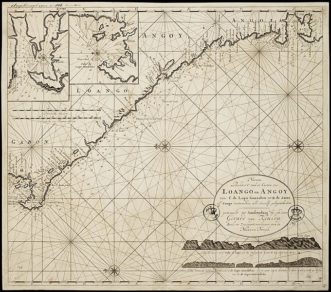
[edit]Nederlands: Kaart van de kusten van Gabon, Loanga en Angola
English: Map of the coasts of Gabon, Loanga and Angola( |
||||||||||||||||||||||||
|---|---|---|---|---|---|---|---|---|---|---|---|---|---|---|---|---|---|---|---|---|---|---|---|---|
| Author |
Nederlands: Gerard van Keulen (landmeter / kaartenmaker), Gerard van Keulen (uitgever)
English: Gerard van Keulen (land surveyor / mapmaker), Gerard van Keulen (publisher) |
|||||||||||||||||||||||
| Title |
Nederlands: Kaart van de kusten van Gabon, Loanga en Angola
English: Map of the coasts of Gabon, Loanga and Angola |
|||||||||||||||||||||||
| Description |
Nederlands: Kaart van de kusten van Gabon, Loanga en Angola.
Titel catalogus Leupe (NA): Nieuwe Paskaart van de Custen Zee Loango en Angoy, van Cabo de Lopo Gonsalves tot R. de Zaire off Congo, vertoonende alle desselfs gelegentheden. Uitgegeven door Gerard van Keulen. Met twee stempeltjes Marine. De kaart is op blauw papier geplakt. Notities verso: 15. Linksboven twee inzetten met respectievelijk de Cabo de Lopo Gonsalves en de Rio Corigo. Rechtsonder aanzichten van Cabo de Lopo Gonsalves.English: Map of the coasts of Gabon, Loanga, and Angola.
Title in the Leupe catalogue (NA): Nieuwe Paskaart van de Custen Zee Loango en Angoy, van Cabo de Lopo Gonsalves tot R. de Zaire off Congo, vertoonende alle desselfs gelegentheden. Published by Gerard van Keulen. With two stamps Marine. The map has been pasted onto blue paper. Notes on reverse: 15. Top left, two insets showing the Cabo de Lopo Gonsalves and the Rio Corigo respectively. Bottom right views of the Cabo de Lopo Gonsalves. |
|||||||||||||||||||||||
| Date | between 1700 and 1727 | |||||||||||||||||||||||
| Medium |
Nederlands: koperdruk op papier
English: copperplate printing on paper |
|||||||||||||||||||||||
| Dimensions | height: 59 cm (23.2 in); width: 52 cm (20.4 in) | |||||||||||||||||||||||
| Collection |
|
|||||||||||||||||||||||
| Accession number |
NL-HaNA_4.VEL_146 (old number: VEL0146) |
|||||||||||||||||||||||
| Inscriptions |
Nieuwe Paskaert van de Custen Zee Loango en Angoy / van C: de Lopo Gonzalves tot R: de Zaire of Congo vertoonende alle desselfs gelegentheden
author: gemaakt tot Amsterdam By: en door Gerard van Keulen Boek en zeekaartverkooper aen de Nieuwen Brugh |
|||||||||||||||||||||||
| Notes |
English: Subjects: chart / map / plan, compass / dial
Nederlands: Onderwerpen: plattegrond / kaart, kompas / windroos
English: Post: this image is related to a WIC trading post called Mayumba |
|||||||||||||||||||||||
| Source/Photographer |
|
|||||||||||||||||||||||
| Permission (Reusing this file) |
|
|||||||||||||||||||||||

| Object location | | View this and other nearby images on: OpenStreetMap |
|---|
File history
Click on a date/time to view the file as it appeared at that time.
| Date/Time | Thumbnail | Dimensions | User | Comment | |
|---|---|---|---|---|---|
| current | 10:02, 11 June 2014 | | 2,400 × 2,115 (1,016 KB) | HuskyBot (talk | contribs) | == {{int:filedesc}} == {{Artwork |title = {{nl|1=Kaart van de kusten van Gabon, Loanga en Angola}} {{en|1=Map of the coasts of Gabon, Loanga and Angola}} |description = {{nl|1=Kaart van de kusten van Gabon, Loa... |
You cannot overwrite this file.
File usage on Commons
The following page uses this file:
File usage on other wikis
The following other wikis use this file:
- Usage on fr.wikipedia.org