File:AMH-7269-KB Floor plan of the lodge at Barsaloor.jpg
Original file (1,514 × 2,400 pixels, file size: 597 KB, MIME type: image/jpeg)
Captions
Captions
Summary
[edit]Nederlands: Plattegrond van de loge te Barsaloor
English: Floor plan of the lodge at Barsaloor( |
|||||||||||||||||||||||||||||||||||||||
|---|---|---|---|---|---|---|---|---|---|---|---|---|---|---|---|---|---|---|---|---|---|---|---|---|---|---|---|---|---|---|---|---|---|---|---|---|---|---|---|
| Author |
Creator:Laurens Nicolaesz. Duyrendaal Creator:Adam vander Duyn Nederlands: J. van Braam (uitgever), Gerard onder de Linden (uitgever), Laurens Nicolaesz. Duyrendaal (landmeter / kaartenmaker), Adam vander Duyn (opdrachtgever)
English: J. van Braam (publisher), Gerard onder de Linden (publisher), Laurens Nicolaesz. Duyrendaal (land surveyor / mapmaker), Adam vander Duyn (patron) |
||||||||||||||||||||||||||||||||||||||
| Title |
Nederlands: Plattegrond van de loge te Barsaloor
English: Floor plan of the lodge at Barsaloor |
||||||||||||||||||||||||||||||||||||||
| Description |
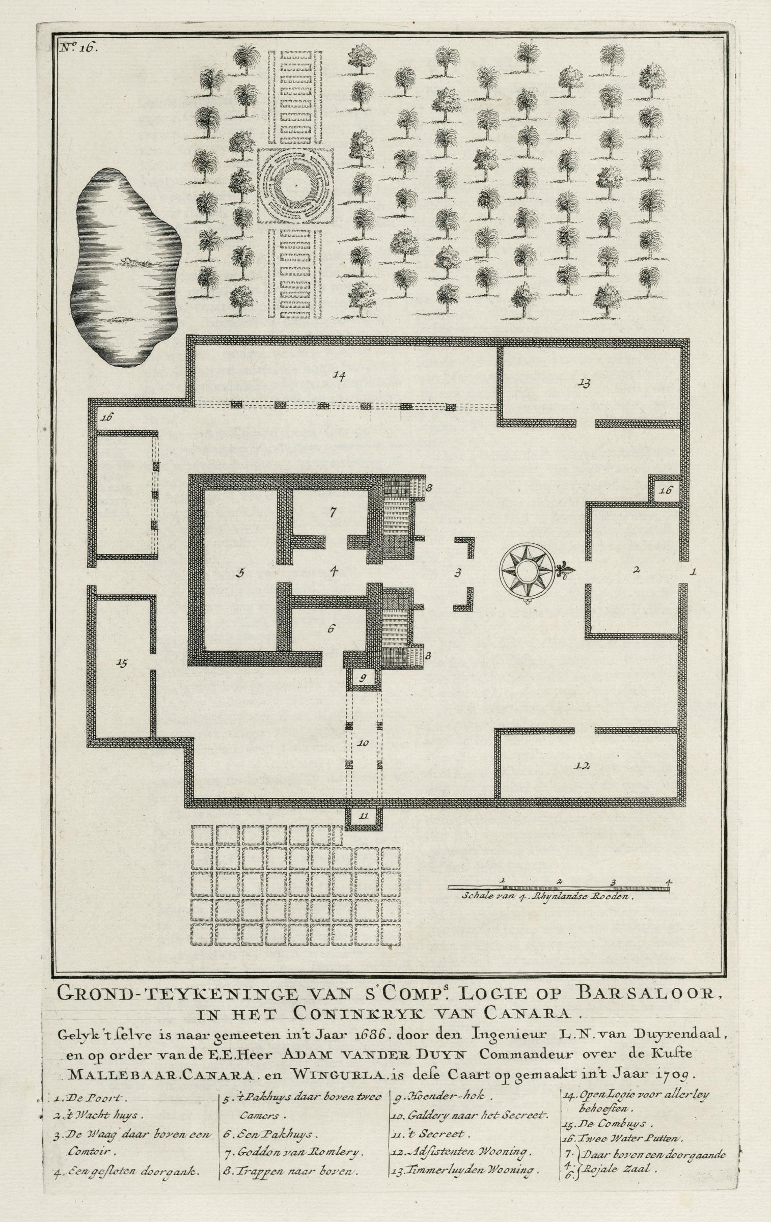
Nederlands: Plattegrond van de loge te Barsaloor.
Grond-teykeninge van s'Comp:s Logie op Barsaloor. In het Coninkryk van Canara. Op de kaart zijn legendanummers gegeven en verklaard. Linksboven: No: 16. De kaart is afkomstig uit Valentijn's 'Oud en Nieuw Oost-Indiën'.English: Floor plan of the lodge at Barsaloor.
Grond-teykeninge van s'Comp:s Logie op Barsaloor. In het Coninkryk van Canara. The map features a numbered key with explanatory notes. Top left: No:16. The floor plan is taken from Valentijn's 'Oud en Nieuw Oost-Indien'. |
||||||||||||||||||||||||||||||||||||||
| Date | 1709 | ||||||||||||||||||||||||||||||||||||||
| Medium |
Nederlands: gravure op papier
English: engraving on paper |
||||||||||||||||||||||||||||||||||||||
| Dimensions | height: 19 cm (7.4 in); width: 31 cm (12.2 in) | ||||||||||||||||||||||||||||||||||||||
| Collection |
|
||||||||||||||||||||||||||||||||||||||
| Accession number |
185 A 5 deel Vb, II, na p. 6 |
||||||||||||||||||||||||||||||||||||||
| Inscriptions |
Grond-teykeninge van s'Comp:s Logie op Barsaloor. In het Coninkryk van Canara
author: Gelyk 't selve is naar gemeeten in 't Jaar 1686. door den Ingenieur L.N. van Duyrendaal, en op order van de E.E. Heer Adam van der Duyn Commandeur over de Kuste Mallebaar, Canara, en Wingurla is dese Caart opgemaakt in 't Jaar 1709 |
||||||||||||||||||||||||||||||||||||||
| Notes |
English: Subjects: chart / map / plan, gate, guard house / tollbooth, warehouse, house, tanck / well / watering hole, garden / ornamental garden, compass / dial, building
Nederlands: Onderwerpen: plattegrond / kaart, poort, tolhuis / wachthuis, pakhuis, huis / woonhuis, tanck / waterplaats / put, tuin / siertuin, kompas / windroos, gebouw
English: Post: this image is related to a VOC trading post called Kundapura |
||||||||||||||||||||||||||||||||||||||
| Source/Photographer |
|
||||||||||||||||||||||||||||||||||||||
| Permission (Reusing this file) |
|
||||||||||||||||||||||||||||||||||||||

| Object location | | View this and other nearby images on: OpenStreetMap |
|---|
File history
Click on a date/time to view the file as it appeared at that time.
| Date/Time | Thumbnail | Dimensions | User | Comment | |
|---|---|---|---|---|---|
| current | 12:48, 10 June 2014 | | 1,514 × 2,400 (597 KB) | HuskyBot (talk | contribs) | == {{int:filedesc}} == {{Artwork |title = {{nl|1=Plattegrond van de loge te Barsaloor}} {{en|1=Floor plan of the lodge at Barsaloor}} |description = {{nl|1=Plattegrond van de loge te Barsaloor. ''Grond-teykeni... |
You cannot overwrite this file.
File usage on Commons
The following page uses this file: