File:AMH-6798-NA Bird's eye view of the bay and the fort of Nieuw Vlissingen on Tobago.jpg

Original file (2,400 × 1,786 pixels, file size: 508 KB, MIME type: image/jpeg)
Captions
Captions
Summary
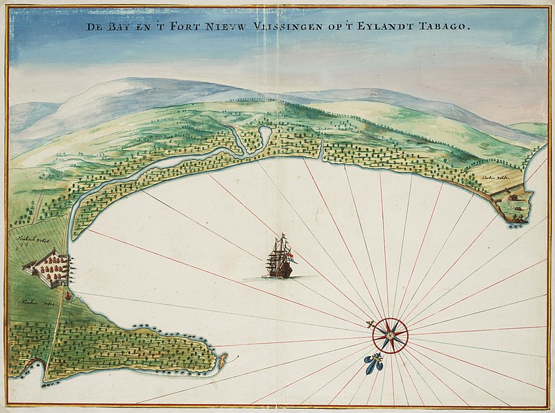
[edit]| Nederlands: Vogelvlucht van baai en fort Nieuw Vlissingen op Tobago
English: Bird's eye view of the bay and the fort of Nieuw Vlissingen on Tobago ( |
||||||||||||||||||||||||
|---|---|---|---|---|---|---|---|---|---|---|---|---|---|---|---|---|---|---|---|---|---|---|---|---|
| Author |
Nederlands: Johannes Vingboons (landmeter / kaartenmaker)
English: Johannes Vingboons (land surveyor / mapmaker) |
|||||||||||||||||||||||
| Title |
Nederlands: Vogelvlucht van baai en fort Nieuw Vlissingen op Tobago
English: Bird's eye view of the bay and the fort of Nieuw Vlissingen on Tobago |
|||||||||||||||||||||||
| Description |
Nederlands: Titel catalogus Leupe (NA): Kaart van "de baij en 't fort Nieuw-Vlissingen op 't eijlandt Tabago".
Vogelvlucht van baai en fort Nieuw Vlissingen op Tobago. De Bay en 't Fort Nieuw Vlissingen op 't Eylandt Tabago. Bijzonderheden: de kaart hoort bij de Atlas Vingboons.English: Title in the Leupe catalogue (NA): Kaart van "de baij en 't fort Nieuw-Vlissingen op 't eijlandt Tabago".
Bird's eye view of the bay and the fort of Nieuw Vlissingen on Tobago. De Bay en 't Fort Nieuw Vlissingen op 't Eylandt Tabago. Remarks: the map is contained in the Vingboons Atlas. |
|||||||||||||||||||||||
| Date | circa 1665 | |||||||||||||||||||||||
| Medium |
Nederlands: aquarel/waterverf op papier
English: watercolour on paper |
|||||||||||||||||||||||
| Dimensions | height: 56 cm (22 in); width: 42 cm (16.5 in) | |||||||||||||||||||||||
| Collection |
|
|||||||||||||||||||||||
| Accession number |
NL-HaNA_4.VELH_619.100 (old number: VELH0619.100) |
|||||||||||||||||||||||
| Inscriptions |
De Bay en 't Fort Nieuw Vlissingen op 't Eylandt Tabago
|
|||||||||||||||||||||||
| Notes |
English: Subjects: bird's-eye view / elevation, elevation / bird's-eye view, ship / vessel, compass / dial, chart / map / plan, estate / plantation, building, house, fence / kraal
Nederlands: Onderwerpen: vogelvlucht / opstand, opstand / vogelvlucht, schip / vaartuig, kompas / windroos, plattegrond / kaart, landerij / plantage, gebouw, huis / woonhuis, omheining / kraal
English: Post: this image is related to a WIC trading post called Plymouth |
|||||||||||||||||||||||
| Source/Photographer |
|
|||||||||||||||||||||||
| Permission (Reusing this file) |
|
|||||||||||||||||||||||
| Other versions |
|
|||||||||||||||||||||||


| Object location | | View this and other nearby images on: OpenStreetMap |
|---|
File history
Click on a date/time to view the file as it appeared at that time.
| Date/Time | Thumbnail | Dimensions | User | Comment | |
|---|---|---|---|---|---|
| current | 09:53, 11 June 2014 | | 2,400 × 1,786 (508 KB) | HuskyBot (talk | contribs) | == {{int:filedesc}} == {{Artwork |title = {{nl|1=Vogelvlucht van baai en fort Nieuw Vlissingen op Tobago}} {{en|1=Bird's eye view of the bay and the fort of Nieuw Vlissingen on Tobago}} |description = {{nl|1=Ti... |
You cannot overwrite this file.
File usage on Commons
The following 3 pages use this file:
File usage on other wikis
The following other wikis use this file:
- Usage on nl.wikipedia.org
- Usage on nn.wikipedia.org