File:AMH-6663-KB Map of the northern part of India and the Himalayas.jpg
Jump to navigation
Jump to search

Size of this preview: 760 × 599 pixels. Other resolutions: 304 × 240 pixels | 609 × 480 pixels | 974 × 768 pixels | 1,280 × 1,010 pixels | 2,400 × 1,893 pixels.
Original file (2,400 × 1,893 pixels, file size: 1.04 MB, MIME type: image/jpeg)
Captions
Captions
Add a one-line explanation of what this file represents
Summary
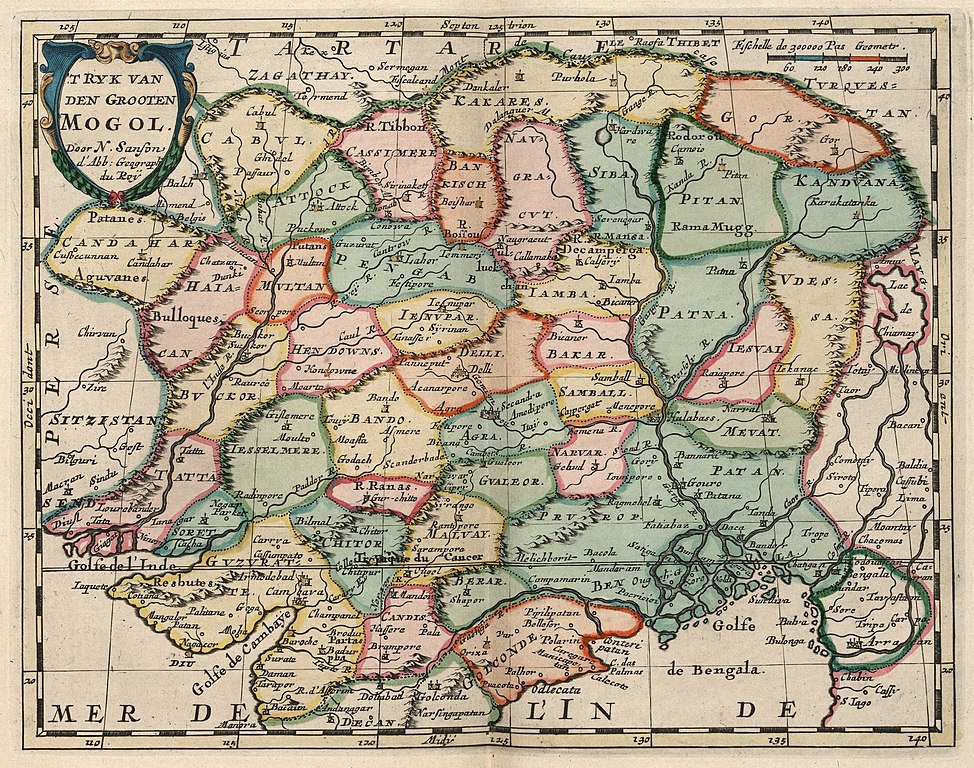
[edit]Nederlands: Kaart van het noordelijk deel van India en de Himalaya
English: Map of the northern part of India and the Himalayas( |
|||||||||||||||||||||||||||||||||||||||||||||||||||||||||||||||||||||||||||
|---|---|---|---|---|---|---|---|---|---|---|---|---|---|---|---|---|---|---|---|---|---|---|---|---|---|---|---|---|---|---|---|---|---|---|---|---|---|---|---|---|---|---|---|---|---|---|---|---|---|---|---|---|---|---|---|---|---|---|---|---|---|---|---|---|---|---|---|---|---|---|---|---|---|---|---|
| Author |
Nederlands: Nicolas Sanson d'Abbeville (landmeter / kaartenmaker), A. d' Winter (graveur / etser), François Halma (uitgever)
English: Nicolas Sanson d'Abbeville (land surveyor / mapmaker), A. d' Winter (engraver / etcher), François Halma (publisher) |
||||||||||||||||||||||||||||||||||||||||||||||||||||||||||||||||||||||||||
| Title |
Nederlands: Kaart van het noordelijk deel van India en de Himalaya
English: Map of the northern part of India and the Himalayas |
||||||||||||||||||||||||||||||||||||||||||||||||||||||||||||||||||||||||||
| Description |
Nederlands: Kaart van het noordelijk deel van India en de Himalaya.
't Ryk van den Grooten Mogol.
English: Map of the northern part of India and the Himalayas.
't Ryk van den Grooten Mogol. |
||||||||||||||||||||||||||||||||||||||||||||||||||||||||||||||||||||||||||
| Date | circa 1705 | ||||||||||||||||||||||||||||||||||||||||||||||||||||||||||||||||||||||||||
| Medium |
Nederlands: ingekleurde gravure op papier
English: coloured engraving on paper |
||||||||||||||||||||||||||||||||||||||||||||||||||||||||||||||||||||||||||
| Dimensions | height: 20 cm (7.8 in); width: 25 cm (9.8 in) | ||||||||||||||||||||||||||||||||||||||||||||||||||||||||||||||||||||||||||
| Collection |
|
||||||||||||||||||||||||||||||||||||||||||||||||||||||||||||||||||||||||||
| Accession number |
368 E 1 deel III, na p. 108 |
||||||||||||||||||||||||||||||||||||||||||||||||||||||||||||||||||||||||||
| Inscriptions |
't Ryk van den Grooten Mogol
author: Door N. Sanson d'Abb: Geographi du Roy |
||||||||||||||||||||||||||||||||||||||||||||||||||||||||||||||||||||||||||
| Notes |
English: Subjects: chart / map / plan, banderole / cartouche / ornamentation
Nederlands: Onderwerpen: plattegrond / kaart, banderol / cartouche / versiering
English: Post: this image is related to a VOC trading post called Diu |
||||||||||||||||||||||||||||||||||||||||||||||||||||||||||||||||||||||||||
| Source/Photographer |
|
||||||||||||||||||||||||||||||||||||||||||||||||||||||||||||||||||||||||||
| Permission (Reusing this file) |
|
||||||||||||||||||||||||||||||||||||||||||||||||||||||||||||||||||||||||||


| Object location | | View this and other nearby images on: OpenStreetMap |
|---|
File history
Click on a date/time to view the file as it appeared at that time.
| Date/Time | Thumbnail | Dimensions | User | Comment | |
|---|---|---|---|---|---|
| current | 11:16, 10 June 2014 | | 2,400 × 1,893 (1.04 MB) | HuskyBot (talk | contribs) | == {{int:filedesc}} == {{Artwork |title = {{nl|1=Kaart van het noordelijk deel van India en de Himalaya}} {{en|1=Map of the northern part of India and the Himalayas}} |description = {{nl|1=Kaart van het noordel... |
You cannot overwrite this file.
File usage on Commons
The following 3 pages use this file: