File:AMH-6125-NA Cross section of the fortifications at Trincomalee, part B.jpg

Original file (2,400 × 411 pixels, file size: 71 KB, MIME type: image/jpeg)
Captions
Captions
Summary
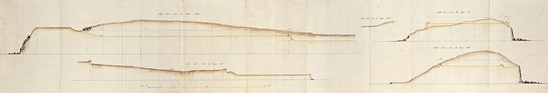
[edit]Nederlands: Profielen van de vestingwerken te Trincomalee, deel B
English: Cross section of the fortifications at Trincomalee, part B( |
||||||||||||||||||||||||
|---|---|---|---|---|---|---|---|---|---|---|---|---|---|---|---|---|---|---|---|---|---|---|---|---|
| Author |
Creator:De la Lustière Creator:La Goupillière Nederlands: de la Lustière (landmeter / kaartenmaker), La Goupillière (landmeter / kaartenmaker)
English: de la Lustière (land surveyor / mapmaker), La Goupillière (land surveyor / mapmaker) |
|||||||||||||||||||||||
| Title |
Nederlands: Profielen van de vestingwerken te Trincomalee, deel B
English: Cross section of the fortifications at Trincomalee, part B |
|||||||||||||||||||||||
| Description |
Nederlands: Titel catalogus Leupe (NA): Plan du Fort de Trinquemale, relatif au projet de 1787.
Notities verso: Feuille 13e Trinquemale. Profils Relatifs aux Projets de 1787.. Vier doorsnedes. Onderin is de schaalverdeling.English: Title in the Leupe catalogue (NA): Plan du Fort de Trinquemale, relatif au projet de 1787.
Notes on reverse: Feuille 13e Trinquemale. Profils Relatifs aux Projets de 1787.. Four cross sections. The scale is given at the bottom. |
|||||||||||||||||||||||
| Date | 1787 | |||||||||||||||||||||||
| Medium |
Nederlands: ingekleurde tekening op papier
English: coloured drawing on paper |
|||||||||||||||||||||||
| Dimensions | height: 206 cm (81.1 in); width: 36 cm (14.1 in) | |||||||||||||||||||||||
| Collection |
|
|||||||||||||||||||||||
| Accession number |
NL-HaNA_4.VEL_1015B (old number: VEL1015B) |
|||||||||||||||||||||||
| Inscriptions |
-
|
|||||||||||||||||||||||
| Notes |
English: Subjects: fortification, flora, cross-section / profile
Nederlands: Onderwerpen: vesting, flora, doorsnede / profiel
English: Post: this image is related to a VOC trading post called Trincomalee |
|||||||||||||||||||||||
| Source/Photographer |
|
|||||||||||||||||||||||
| Permission (Reusing this file) |
|
|||||||||||||||||||||||

| Object location | | View this and other nearby images on: OpenStreetMap |
|---|
File history
Click on a date/time to view the file as it appeared at that time.
| Date/Time | Thumbnail | Dimensions | User | Comment | |
|---|---|---|---|---|---|
| current | 09:03, 11 June 2014 | 2,400 × 411 (71 KB) | HuskyBot (talk | contribs) | == {{int:filedesc}} == {{Artwork |title = {{nl|1=Profielen van de vestingwerken te Trincomalee, deel B}} {{en|1=Cross section of the fortifications at Trincomalee, part B}} |description = {{nl|1=Titel catalogus... |
You cannot overwrite this file.
File usage on Commons
The following page uses this file: