File:AMH-6065-NA Map of the village of Kotta near Colombo.jpg
Original file (2,400 × 1,703 pixels, file size: 375 KB, MIME type: image/jpeg)
Captions
Captions
Summary
[edit]Nederlands: Kaart van het dorp Kotta bij Colombo
English: Map of the village of Kotta near Colombo( |
||||||||||||||||||||||||
|---|---|---|---|---|---|---|---|---|---|---|---|---|---|---|---|---|---|---|---|---|---|---|---|---|
| Author |
Nederlands: P. Elias (landmeter / kaartenmaker)
English: P. Elias (land surveyor / mapmaker) |
|||||||||||||||||||||||
| Title |
Nederlands: Kaart van het dorp Kotta bij Colombo
English: Map of the village of Kotta near Colombo |
|||||||||||||||||||||||
| Description |
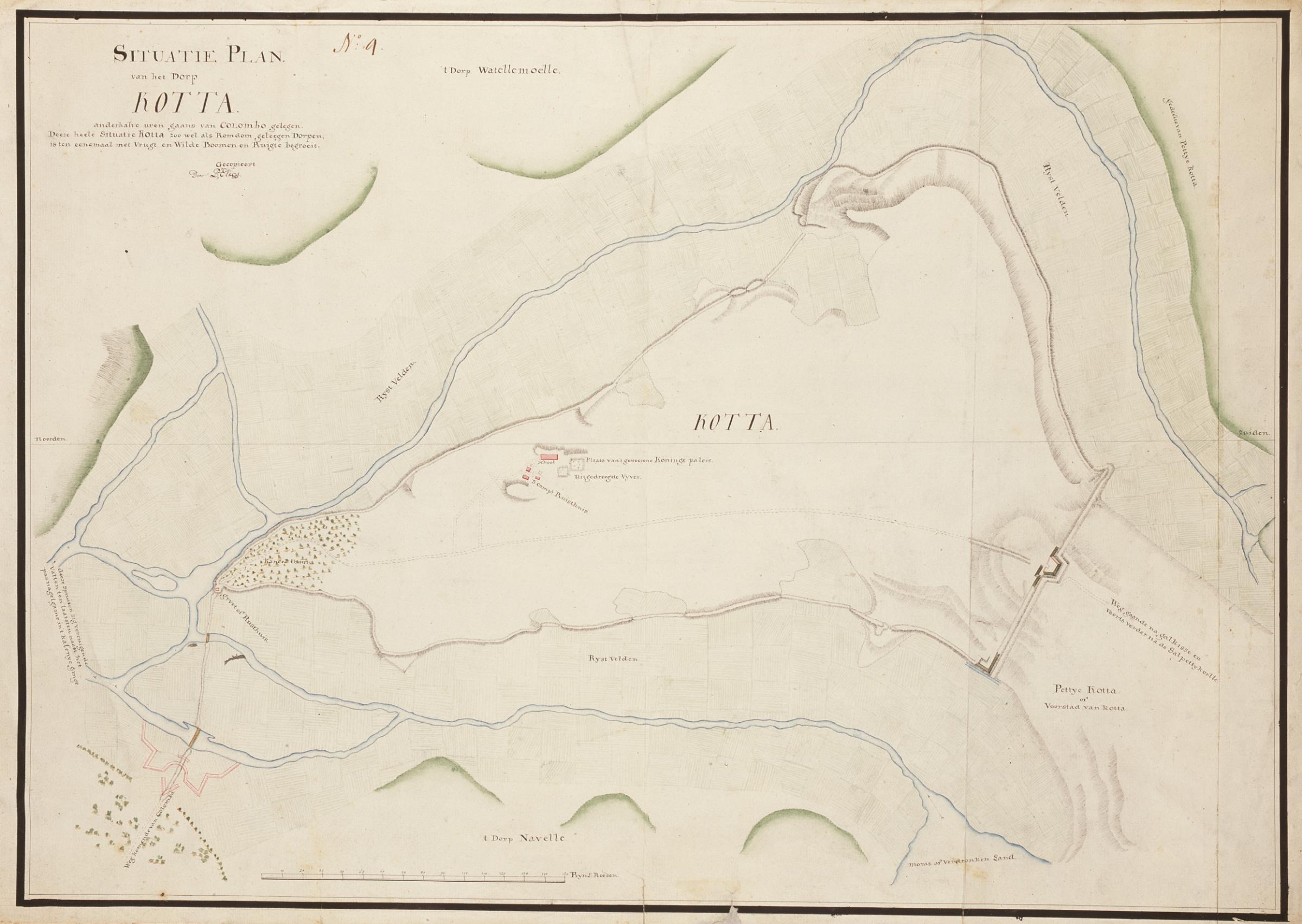
Nederlands: Titel catalogus Leupe (NA): Situatie-plan van het Dorp Kotta, anderhalf uur gaans van Colombo gelegen.
Bijzonderheden: het betreft een kopie, linksboven genummerd No. 4. Notities verso: No. 4 Colombo, No. 4, 541 [met vette cijfers gestempeld op een etiketje]. Op de afbeelding wordt Kotta weergegeven met school, S Comp Ruisthuys, uitgedroogde vijver, Plaats van 't geweesene Konings paleis, Kaneel thuin. Kotta wordt omringd met land, rivieren en rijstvelden 't Dorp Watellemoelle, Rystvelden, deeze Spruiten zig verenigen de vallen ten laatsten naast het pas nagekgame in 't kalenye, gange, weg komende van Colombo, 't Dorp Navelle, Pettye Kotta of Voorstad van Kotta, Weg gaande na galkisse en voorts verder na de Salpettykortte. Rechtsonder de schaalverdeling in Rhijns Roeden.English: Titel catalogus Leupe (NA): Situatie-plan van het Dorp Kotta, anderhalf uur gaans van Colombo gelegen.
Bijzonderheden: het betreft een kopie, linksboven genummerd No. 4. Notities verso: No. 4 Colombo, No. 4, 541 [met vette cijfers gestempeld op een etiketje]. Op de afbeelding wordt Kotta weergeven met school, S Comp Ruisthuys, uitgedroogde vijver, Plaats van 't geweesene Konings paleis, Kaneel thuin. Kotta wordt omringd met land, rivieren en rijstvelden 't Dorp Watellemoelle, Rystvelden, deeze Spruiten zig verenigen de vallen ten laatsten naast het pas nagekgame in 't kalenye, gange, weg komende van Colombo, 't Dorp Navelle, Pettye Kotta of Voorstad van Kotta, Weg gaande na galkisse en voorts verder na de Salpettykortte. Rechtsonder de schaalverdeling in Rhijns Roeden. |
|||||||||||||||||||||||
| Medium |
Nederlands: ingekleurde tekening op papier
English: coloured drawing on paper |
|||||||||||||||||||||||
| Dimensions | height: 70 cm (27.5 in); width: 49.5 cm (19.4 in) | |||||||||||||||||||||||
| Collection |
|
|||||||||||||||||||||||
| Accession number |
NL-HaNA_4.VEL_981 (old number: VEL0981) |
|||||||||||||||||||||||
| Inscriptions |
Situatie Plan van het Dorp Kotta. anderhalve uren gaans van Colombo gelegen. Deeze heele Situatie Kotta 200 wet als Romdom, geleegen Dorpen, is ten eenemaal met Vrugt en Wilde Boomen en Ruigte begroeit. author: gecopieert door P. Elias |
|||||||||||||||||||||||
| Notes |
English: Subjects: building, chart / map / plan, fortification, school, flora, house, bridge
Nederlands: Onderwerpen: gebouw, plattegrond / kaart, vesting, school, flora, huis / woonhuis, brug |
|||||||||||||||||||||||
| Source/Photographer |
|
|||||||||||||||||||||||
| Permission (Reusing this file) |
|
|||||||||||||||||||||||

File history
Click on a date/time to view the file as it appeared at that time.
| Date/Time | Thumbnail | Dimensions | User | Comment | |
|---|---|---|---|---|---|
| current | 08:52, 11 June 2014 | | 2,400 × 1,703 (375 KB) | HuskyBot (talk | contribs) | == {{int:filedesc}} == {{Artwork |title = {{nl|1=Kaart van het dorp Kotta bij Colombo}} {{en|1=Map of the village of Kotta near Colombo}} |description = {{nl|1=Titel catalogus Leupe (NA): ''Situatie-plan van he... |
You cannot overwrite this file.
File usage on Commons
The following page uses this file: