File:AMH-5625-NA Map of Saldanha Bay, Table Bay, Hout Bay and False Bay.jpg
Original file (2,400 × 1,645 pixels, file size: 775 KB, MIME type: image/jpeg)
Captions
Captions
Summary
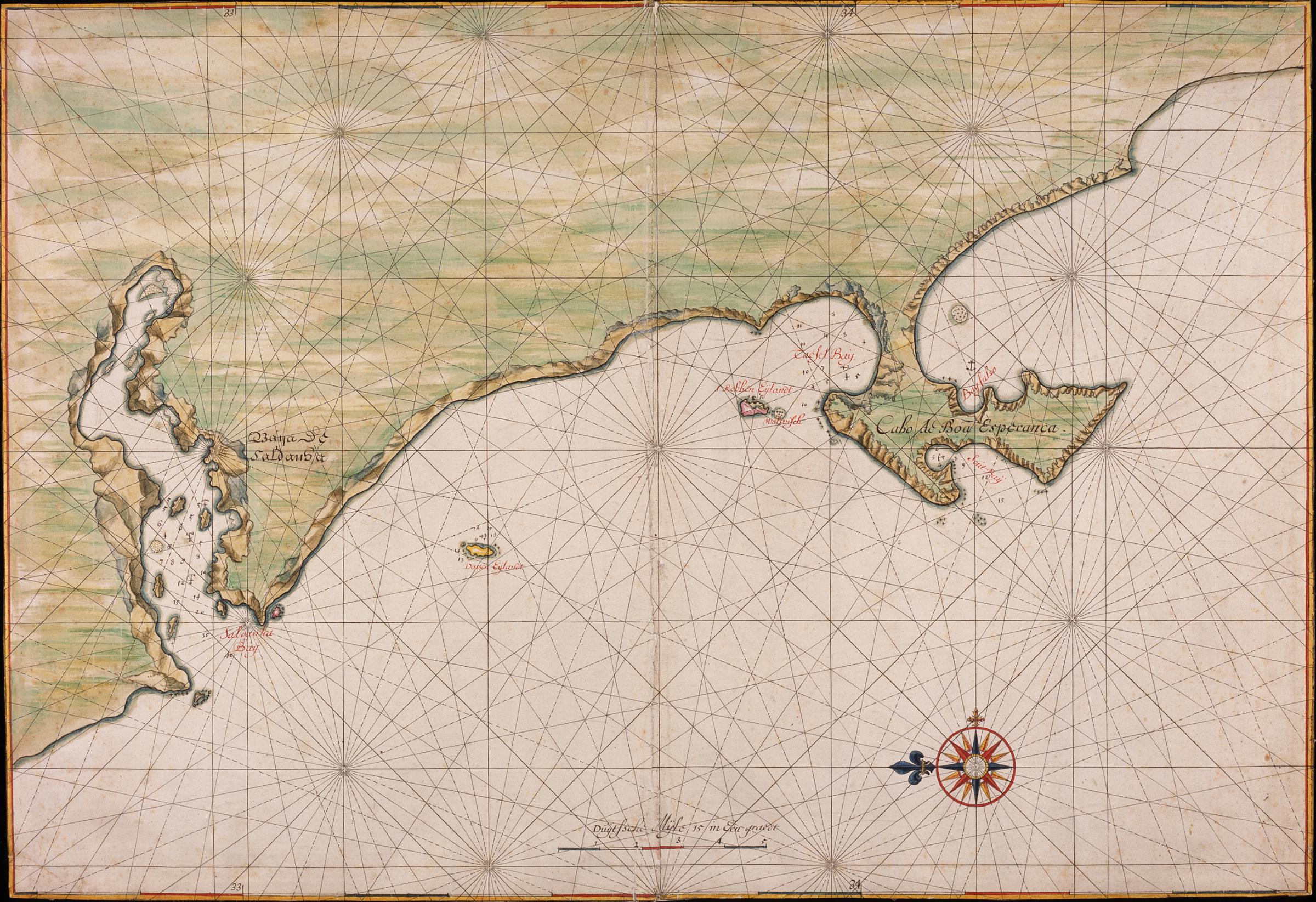
[edit]| Nederlands: Kaart van de Saldanhabaai, Tafelbaai, Houtbaai en de Baai Fals
English: Map of Saldanha Bay, Table Bay, Hout Bay and False Bay ( |
||||||||||||||||||||||||
|---|---|---|---|---|---|---|---|---|---|---|---|---|---|---|---|---|---|---|---|---|---|---|---|---|
| Author |
Nederlands: Johannes Vingboons (landmeter / kaartenmaker)
English: Johannes Vingboons (land surveyor / mapmaker) |
|||||||||||||||||||||||
| Title |
Nederlands: Kaart van de Saldanhabaai, Tafelbaai, Houtbaai en de Baai Fals
English: Map of Saldanha Bay, Table Bay, Hout Bay and False Bay |
|||||||||||||||||||||||
| Description |
Nederlands: Titel catalogus Leupe (NA): Kaart van de Saldanhabaai, Tafelbaai, Houtbaai en Baai Fals. Met loodingen.
Bijzonderheden: de kaart maakt deel uit van de Atlas Vingboons. Volgens een opmerking in de catalogus "Inventaris der Verzameling kaarten beristende in het Algemeen Rijksarchief", eerste supplement, 's-Gravenhage 1914 komt de kaart overeen met de kaart uit Valentijn, V, 2e stuk, p. 4. Cf. Österreichische Nationalbibliothek, Wenen, inv. nr. Van der Hem 35:46 en British Library, Londen, inv. nr. ADD.34.184-5.English: Title in the Leupe catalogue (NA): Kaart van de Saldanhabaai, Tafelbaai, Houtbaai en Baai Fals. Met loodingen.
Particulars: the map forms part of the Vingboons Atlas. According to a note in the catalogue "Inventaris der Verzameling kaarten beristende in het Algemeen Rijksarchief", ["Inventory of the collection of maps residing in the State Archives"], first supplement, The Hague, 1914, the map corresponds to that contained in Valentijn, V, part 2, p.4. Cf. Österreichische Nationalbibliothek, Vienna, inv. nr. Van der Hem 35:46 and British Library, London, inv. nr. ADD.34.184-5. |
|||||||||||||||||||||||
| Date | circa 1665 | |||||||||||||||||||||||
| Medium |
Nederlands: ingekleurde tekening op papier
English: coloured drawing on paper |
|||||||||||||||||||||||
| Dimensions | height: 69 cm (27.1 in); width: 47.5 cm (18.7 in) | |||||||||||||||||||||||
| Collection |
|
|||||||||||||||||||||||
| Accession number |
NL-HaNA_4.VELH_619.35 (old number: VELH0619.35) |
|||||||||||||||||||||||
| Inscriptions |
-
|
|||||||||||||||||||||||
| Notes |
English: Subjects: compass / dial, chart / map / plan
Nederlands: Onderwerpen: kompas / windroos, plattegrond / kaart
English: Post: this image is related to a VOC trading post called Cape Town |
|||||||||||||||||||||||
| Source/Photographer |
|
|||||||||||||||||||||||
| Permission (Reusing this file) |
|
|||||||||||||||||||||||

| Object location | | View this and other nearby images on: OpenStreetMap |
|---|
File history
Click on a date/time to view the file as it appeared at that time.
| Date/Time | Thumbnail | Dimensions | User | Comment | |
|---|---|---|---|---|---|
| current | 08:45, 11 June 2014 | | 2,400 × 1,645 (775 KB) | HuskyBot (talk | contribs) | == {{int:filedesc}} == {{Artwork |title = {{nl|1=Kaart van de Saldanhabaai, Tafelbaai, Houtbaai en de Baai Fals}} {{en|1=Map of Saldanha Bay, Table Bay, Hout Bay and False Bay}} |description = {{nl|1=Titel cata... |
You cannot overwrite this file.
File usage on Commons
The following page uses this file: