File:AMH-5614-NA Map of the plantations in the area around Negombo.jpg
Jump to navigation
Jump to search

Size of this preview: 790 × 600 pixels. Other resolutions: 316 × 240 pixels | 632 × 480 pixels | 1,012 × 768 pixels | 1,280 × 972 pixels | 2,400 × 1,822 pixels.
Original file (2,400 × 1,822 pixels, file size: 523 KB, MIME type: image/jpeg)
Captions
Captions
Add a one-line explanation of what this file represents
Summary
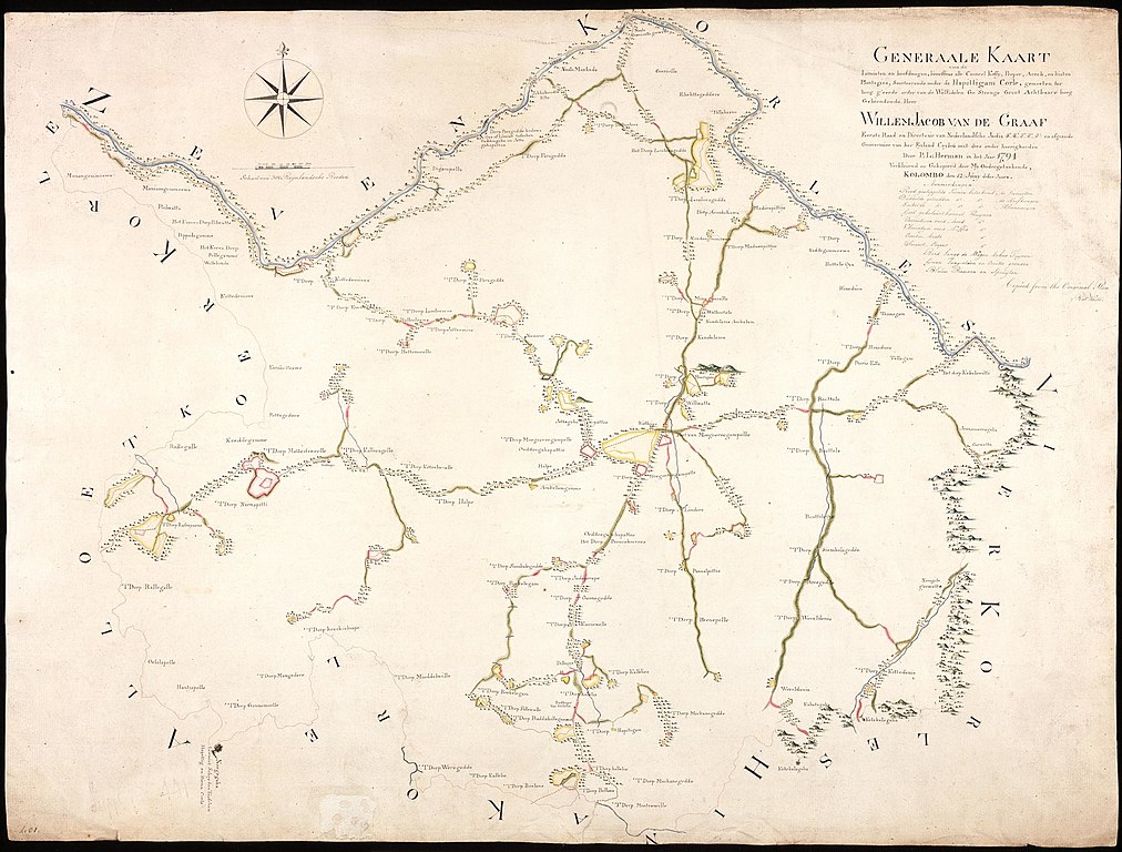
[edit]Nederlands: Kaart van plantages in de omgeving van Negombo
English: Map of the plantations in the area around Negombo( |
||||||||||||||||||||||||
|---|---|---|---|---|---|---|---|---|---|---|---|---|---|---|---|---|---|---|---|---|---|---|---|---|
| Author |
Creator:P.L. Herman Creator:R. White Nederlands: P.L. Herman (gewerkt naar), R. White (landmeter / kaartenmaker)
English: P.L. Herman (copied after), R. White (land surveyor / mapmaker) |
|||||||||||||||||||||||
| Title |
Nederlands: Kaart van plantages in de omgeving van Negombo
English: Map of the plantations in the area around Negombo |
|||||||||||||||||||||||
| Description |
Nederlands: Titel catalogus Leupe (NA): Generaale Kaart van de Limieten en hoofdwegen, beneffens alle Canneel Koffy, Peeper, Areek en kiatenplantagies, Soorteerende onder de Hapittigam Corle.
Bijzonderheden: de kaart is op blauw papier geplakt. Notities verso: Departement voor de Kolonien / No. 401.English: Title in the Leupe catalogue (NA): Generaale Kaart van de Limieten en hoofdwegen, beneffens alle Canneel Koffy, Peeper, Areek en kiatenplantagies, Soorteerende onder de Hapittigam Corle.
Particulars: the map has been pasted onto blue paper. Notes on reverse: Departement voor de Kolonien / No. 401. |
|||||||||||||||||||||||
| Medium |
Nederlands: ingekleurde tekening op papier
English: coloured drawing on paper |
|||||||||||||||||||||||
| Dimensions | height: 65 cm (25.5 in); width: 49 cm (19.2 in) | |||||||||||||||||||||||
| Collection |
|
|||||||||||||||||||||||
| Accession number |
NL-HaNA_4.VELH_333 (old number: VELH0333) |
|||||||||||||||||||||||
| Inscriptions |
Generaale Kaart van de Limieten en hoofdwegen, beneffens alle Canneel Koffy, Peeper, Areek en kiatenplantagies, Soorteerende onder de Hapittigam Corle, gemeeten ter hoog g'eerde order van de WelEdelen Ge Strenge Groot Achtbaare hoog Gebiedende Heer Willem Jacob van de Graaf [...] author: P.L. Herman / Copied from the original Plan Rob.t White |
|||||||||||||||||||||||
| Notes |
English: Subjects: compass / dial, estate / plantation, chart / map / plan
Nederlands: Onderwerpen: kompas / windroos, landerij / plantage, plattegrond / kaart
English: Post: this image is related to a VOC trading post called Negombo |
|||||||||||||||||||||||
| Source/Photographer |
|
|||||||||||||||||||||||
| Permission (Reusing this file) |
|
|||||||||||||||||||||||

| Object location | | View this and other nearby images on: OpenStreetMap |
|---|
File history
Click on a date/time to view the file as it appeared at that time.
| Date/Time | Thumbnail | Dimensions | User | Comment | |
|---|---|---|---|---|---|
| current | 08:43, 11 June 2014 | | 2,400 × 1,822 (523 KB) | HuskyBot (talk | contribs) | == {{int:filedesc}} == {{Artwork |title = {{nl|1=Kaart van plantages in de omgeving van Negombo}} {{en|1=Map of the plantations in the area around Negombo}} |description = {{nl|1=Titel catalogus Leupe (NA): ''G... |
You cannot overwrite this file.
File usage on Commons
The following page uses this file:
File usage on other wikis
The following other wikis use this file:
- Usage on nl.wikipedia.org